[:fr]
Présentation
 |
Localisation et situation géographique:
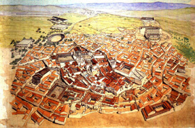
Située au nord-ouest de la Tunisie, dans un pays de montagnes où la température est relativement plus fraîche et où, dans une succession de vallons et de plateaux étagés, le sol est varié et généreux. Elle est bâtie sur un plateau protégé à l’est et au nord-est par une falaise abrupte et au sud par des pentes rapides dominant la riche vallée de l’oued Khalled. Thugga est née de la conjugaison des facteurs indispensables à la naissance d’une agglomération antique: site protégé, position facile à défendre, matériaux de construction à portée de main, sources abondantes et terre fertile à cultiver.
 |
Comment s’y rendre à partir de Tunis?
 |
 |
 |
La découverte du site
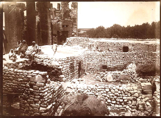
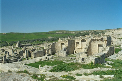
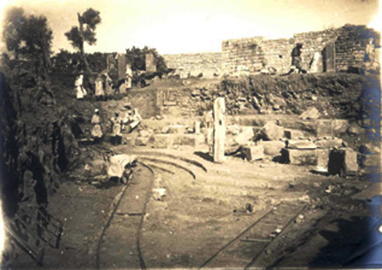
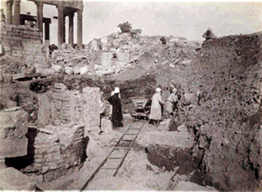
Visitée déjà en 1631 par Thomas d’Arcos, provençal d’origine espagnole, capturé par les corsaires et vendu à un riche marchand de Tunis avant de se racheter et de se convertir à l’Islam, Dougga qui abritait à cette époque un petit hameau agricole, allait devenir à partir du début du XVIIIe siècle l’un des sites archéologiques tunisiens les plus fréquentés par les voyageurs européens. Les recherches commencées au lendemain du protectorat français en 1881 et menées depuis à un rythme plus ou moins soutenu n’ont permis à ce jour que la fouille du tiers du site environ. Elles ont donné lieu à la mise au jour d’un grand nombre de monuments de différentes époques et d’une grande variété. Bon nombre d’entre eux sont uniques en leur genre et font de Dougga un site exceptionnel.
Les potentialités du site
Les vestiges de cette cité qui a abrité au moment de sa plus grande extension une population urbaine estimée à environ 5000 habitants (10.000 habitants si l’on compte ceux qui résidaient sur son exigu territoire), couvrent une superficie totale d’environ 70 ha.
Dougga peut aussi se prévaloir de posséder une collection épigraphique d’une valeur exceptionnelle. Riche de plus de 2000 inscriptions libyques, puniques, néo-puniques grecques et latines, cette collection est d’un apport décisif tant pour le déchiffrement de l’écriture libyque que pour la connaissance de l’organisation sociale et de la vie municipale des Numides, ainsi que pour la compréhension de certains aspects demeurés obscurs de l’histoire de la politique coloniale de Rome et de l’organisation municipale de ses provinces.
À cela s’ajoute une importante collection de mosaïques d’époque romaine dont plus d’une vingtaine sont aujourd’hui soit exposées dans les salles soit conservées dans les réserves du Musée National du Bardo à Tunis. Ces mosaïques figurent différents thèmes de la vie quotidienne (spectacles, beuveries, dieux, déesses…) ainsi que quelques épisodes mythologiques. Ces représentations aident à imaginer et à mieux connaître la mentalité des Thuggenses.
La mise en valeur du site: le Projet présidentiel de Parc Archéologique National
Le 21 juillet 1991 est désormais pour Dougga une date marquée d’une pierre blanche: ce jour-là, en effet, à Carthage, lors d’un Conseil Ministériel, fut prise la décision d’aménager le site de Dougga en un Parc Archéologique National.
- Assurer de manière durable la protection et la sauvegarde de ce site insigne et de son environnement naturel.
- Relancer et développer les études scientifiques du site.
- Aménager et mettre en valeur le site et faire de Dougga une étape principale du tourisme culturel et un vecteur de développement durable.
 |
Histoire
Thugga (Dougga), de l’agglomération numide à la ville africo-romaine
I-Première capitale du royaume Massyle?
Diodore de Sicile (Bibliothèque historique, XX, 57, 4.) nous apprend qu’à l’époque de l’expédition d’Agathocle en Afrique Toccaï / Thugga, l’une des premières villes de l’intérieur des terres prises par Eumachos, lieutenant du tyran de Syracuse, était une « ville d’une belle grandeur ». Sous la plume d’un auteur grec, cette description, bien que très laconique, est suffisante pour supposer que l’agglomération devait être l’une des plus importantes de la région. Cette importance a amené certains savants modernes à l’identifier comme la première capitale du royaume Massyle. Selon d’autres, elle serait même le chef-lieu de la grande circonscription punique de la Tusca, qui englobait une cinquantaine de cités comme l’affirme Appien (Histoire romaine, VIII, 68, cf. S. Gsell, Histoire ancienne de l’Afrique du Nord, V, p. 263-264.).
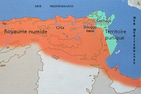 |
L’état des connaissances des vestiges numides:
De l’urbanisme de l’agglomération numide nous connaissons à l’état actuel des fouilles et études:
- des vestiges de nature religieuse
- différents types de monuments funéraires
-
et des vestiges d’habitat.
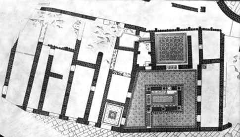
Image Plan du site
– Les vestiges religieux:
– Sanctuaire de Baal Hammon
Des traces d’un lieu de culte consacré à Baal Hammon ont été retrouvées sous les niveaux du temple de Saturne de l’époque romaine (monument n°1 sur le plan) au nord-est du site où des stèles votives portant des inscriptions en néo-punique et en grec ont été trouvées dans des favissae (fosses), et en remploi dans les murs d’enceinte du sanctuaire de l’époque romaine. On a de même mis au jour du matériel votif datable du milieu du IIe siècle avant J.-C. C’est ce qui a permis de déduire qu’un premier sanctuaire était aménagé à cet endroit. Ce premier lieu de culte se présentait sous l’aspect d’une aire à ciel ouvert où se déroulaient les sacrifices et où étaient placés les ex-voto qui en éternisaient le souvenir. Au début du règne de Septime Sévère (193-211 après J.-C.), ce premier sanctuaire fut remblayé sous 2m de terre.
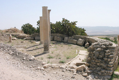
– Le sanctuaire de Massinissa:
Dédié au roi numide Massinissa (148 avant J.-C.) et construit en 139 avant J.-C., ce sanctuaire, (maqdes) (n°14) est situé dans le périmètre de la place publique de l’époque romaine à l’ouest du capitole.
– Les monuments funéraires:
Les monuments funéraires sont situés aux lisières nord et sud du site.
Au nord se trouvent:
- une nécropole dolménique(n°41)
- et des tombes tours et des bazinas (n°42).
Au sud est situé :
- le fameux mausolée libyco-punique (n°54).
-Les vestiges d’habitat
II- Époque romaine: le temps de la coexistence
III- L’époque tardive:
- un monument funéraire: l’hypogée (n°4) qui est resté en usage au IVe siècle après J.C. comme l’attestent les nombreux sarcophages qui y ont été découverts.
- et un monument religieux: église martyriale dite de Victoria (n°3) datable de la fin du IVe-début du Ve siècle après J.-C.
 |
Site et territoire
- Dougga et son territoire: Un divorce qui a trop duré!
 |
 |
 |
 |
 |
 |
 |
- Mokhôla, une divinité païenne d’époque romaine devenue la sainte patronne des Dougguis Qui est «Lella Mokhôla» ?
 |
 |
 |
- Ses miracles
- faire pleuvoir
- guérir les malades
- trouver un mari ou une épouse pour les célibataires
- aider les écoliers, les élèves et les étudiants dans leurs études pour réussir
- fait retourner l’émigré sain et sauf
- apparaît au prisonnier dans sa cellule ou au conscrit sous les drapeaux loin de sa terre natale
- rend surtout, la terre, les femmes et les animaux fertiles.
- Le lieu de culte
Le lieu de culte est le point d’arrivée de l’aqueduc romain de Aïn-El-Hammam dans les citernes du même nom. On dit que son tombeau est situé dans le specus de l’aqueduc.
 |
 |
-
- veiller à l’éclairage par des bougies et des lampes à huile
- aromatiser le lieu par des substances résineuses et aromatiques (l’encens et benjoin «bkhour, jawi, wchak we ded»)
- faire badigeonner le mur de la citerne à la chaux
- collecter les dons d’argent des fidèles pour l’entretien du lieu et si la somme est importante elle sera utilisée pour l’achat de la vache qui sera sacrifiée au cours de la grande procession.
Rites et pratiques Rites et pratiques collectives«La zarda», fête annuelle
- Rites et pratiques Rites et pratiques collectives«La zarda», fête annuelle
- «La zarda», fête annuelle
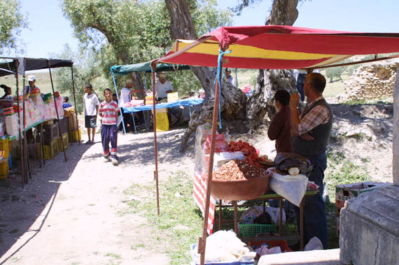
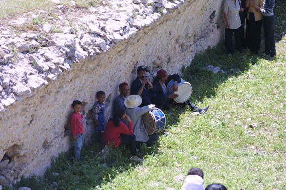
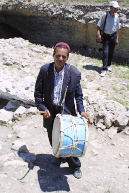
Une fois l’an, au printemps, les citernes de Aïn-El-Hammam et la zone de l’arc de Sévère Alexandre s’animent d’une foule bigarrée. C’est la «zarda» de «Lella Mokhôla». Il s’agit d’une cérémonie populaire à caractère religieux et sacré établie par l’usage dans les mœurs des habitants de Dougga et de sa région.
 |
 |
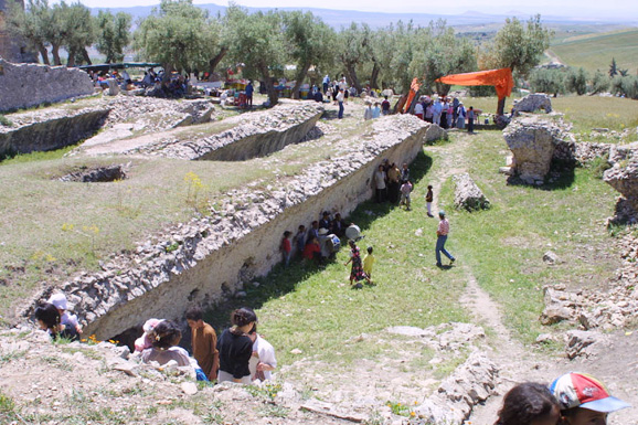 |
Le jour de la fête qui est toujours un vendredi, tous les fidèles sont là et même ceux qui résident loin. On trouve les hommes, les femmes, les enfants, les élèves, les étudiants, les joueurs de flûte et de tambours et surtout les marchands ambulants. Pour ces derniers, la «zarda» est l’un des jours où ils font de bonnes affaires. Ils viennent de bonne heure sur les lieux pour étaler leurs marchandises constituées de jouets pour enfants, bonbons, casse-croûtes, boissons gazeuses, vêtements, bougies, henné, encens, benjoin…
 |
 |
 |
 |
 |
 |
 |
 |
Au cours de cette fête, les fidèles profitent pour faire des vœux auprès de «Lella Mokhôla» pour qu’elle facilite et bénisse leurs réalisations. Ils apportent pour la sainte des bougies, du henné, de l’encens…et les filles inscrivent le nom de l’élu de leur coeur ou du fiancé sur le mur du sanctuaire. Pour chasser le mauvais œil et à titre de prophylaxie et de superstition les femmes surtout dessinent sur le mur un poisson et les cinq doigts de la main dit «la main dite de Fatma» avec du henné ou avec le sang de l’animal.
 |
 |
 |
- En période de sécheresse
- Rites et pratiques individuelles : les « ziaras» occasionnelles et de circonstance
Ces pratiques se font à longueur d’année. Elles consistent en des visites, «ziaras» individuelles ou familiales. L’objet de la visite varie d’un fidèle à l’autre mais les occasions et circonstances sont en général les suivantes:
- Circoncision
La maman fait venir son fils à «Lella Mokhôla» généralement le jour même de la circoncision mais avant la cérémonie sauf s’ils habitent loin. Elle égorge un coq devant le sanctuaire qu’elle reprend avec elle pour le manger en famille et laisse les entrailles, les pâtes et la tête dans le sanctuaire à titre de «baraka». Et c’est toujours les mêmes gestes qui se répètent on apporte les bougies, le henné, l’encens…
- Mariage
- Fertilité et guérison:
En cas de stérilité, hommes et femmes font des prières auprès de la sainte pour les guérir et leur donner des enfants. Parfois les gens qui n’ont eu que des garçons prient pour avoir aussi des filles ou le contraire. C’est la même chose en cas de maladie.
- Sa colère:
-
- « fait mourir le voleur qui ne s’amende pas malgré ses avertissements
- et la femme qui l’injurie;
- elle aveugle le chacal qui a bu l’huile des lampes».
Culte de nature païenne:
- Culte de nature païenne:
 |
«Pour la sauvegarde de l’empereur César Marc Aurèle Commode Antonin Auguste, Pieux, vainqueur des Sarmates, vainqueur des Bretons, père de la patrie, la civitas Aurelia de Thugga a amené l’aqueduc depuis la source Moccolitane, elle l’a construit à ses frais depuis le septième mille, a édifié un nymphée [avec son ornementation?]; Marcus Antonius Zeno, proconsul d’Afrique a fait la dédicace.»
Après l’étude approfondie de cette inscription, l’on a pu montrer que le culte de cette sainte est d’origine païenne. Il a commencé avec l’arrivée de l’eau de la source Moccolitane (= Aïn-El-Hammam) à Thugga entre 184-187. En effet, le nom Mokhôula n’a aucun sens en langue arabe. Il ne peut que dériver d’un terme antique perpétuant à son tour un héritage de l’Antiquité. L’acte même d’offrir des sacrifices dans les sanctuaires est une tradition païenne.
Le culte des femmes saintes est très répandu en Tunisie. À Tunis, à titre d’exemple, on a «Lella Manoubia» ou «Es-saïda Manoubia», «Lella Arbia» et «Lella Salha». La différence avec celles-ci jusqu’à la preuve du contraire est que pour le cas de notre sainte Mokhôla le rite s’est avéré plus ancien, remontant en effet à l’époque romaine. Et comme écrit l’historien Azedine Beschaouch à ce propos : «la romanité africaine a pu se terrer dans les plis de la mémoire populaire et il lui arrive de se manifester encore». Ce qui importe c’est que ce sanctuaire est l’endroit aujourd’hui où les Dougguis continuent à revenir sur le site pour rendre hommage à leur sainte patronne Mokhôla.
Vestiges numides
 |
- Les vestiges religieux:
Sanctuaire de Baal Hamon:
Dans le sous-sol de la cour du temple de Saturne (n°1 sur le plan) au nord-est du site, ont été effectués des sondages qui ont révélé des restes d’un sanctuaire plus ancien où était vénéré Baal Hamon, le grand dieu de l’Afrique préromaine, devenu Saturnus à l’époque romaine.Des stèles votives portant des inscriptions en néo-punique et en grec ont été trouvées dans des favissae (fosses) et en remploi dans les murs d’enceinte du sanctuaire de l’époque romaine. On a de même mis au jour du matériel votif datable du milieu du IIe siècle avant J.-C.
Ce lieu de culte se présentait sous l’aspect d’une aire à ciel ouvert où se déroulaient les sacrifices et où étaient placés les ex-voto qui en éternisaient le souvenir. Au début du règne de Septime Sévère (193-211 après J.-C.), ce premier sanctuaire fut remblayé sous 2m de terre.
Le maqdes (sanctuaire) de Massinissa:
Dédié à la mémoire du roi numide Massinissa (-148 avant J.-C.) et construit en 139 avant J.-C., ce sanctuaire, (maqdes) (n°14) est situé dans le périmètre de la place publique de l’époque romaine à l’ouest du capitole.
Construit avec des blocs quadrangulaires d’un travail bien soigné et doté d’un soubassement mouluré, il a un plan rectangulaire mesurant 14, 65m de long et 6, 30m de large qui est comparable à celui du sanctuaire numide de Simitthus construit lui aussi sous le règne de Micipsa (148-118 avant J.-C.).
Avant son identification, ce sanctuaire n’était connu que par une inscription bilingue, en punique et en libyque, trouvée en 1904 dans le secteur au sud-ouest du forum et conservée depuis au Musée National du Bardo. Datée exactement de l’an dix du règne de Micipsa (139 avant J.-C.), elle commémore la construction par les notables de Thugga d’un maqdes (sanctuaire) au défunt Massinissa.
L’indentification de ce monument dans cet endroit est l’une des preuves archéologiques qui témoignent que le quartier du forum n’a pas attendu l’arrivée des Romains pour être urbanisé et qu’il était déjà l’agora de la ville de l’époque royale.
Les monuments funéraires:
Les monuments funéraires de l’époque numide sont situés aux lisières nord et sud du site.
La nécropole dolménique (n°41)
Située au nord-ouest de la ville, cette nécropole est constituée de sépultures de type dolmen, de tombes tours et de bazinas.
Les dolmens:
Ce type de monument funéraire est une sorte de caisson ouvert sur un côté et composé de trois dalles posées de champ sur lesquelles repose une dalle de couverture souvent de taille impressionnante.
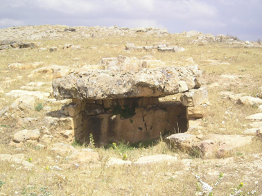 |
Dans la plupart des cas il s’agit de tombes collectives. Grâce au côté ouvert l’usage répété de la tombe était possible: on devait fermer ce côté après usage par un muret en pierres sèches facile à enlever.
En plus des squelettes humains, ont été découverts dans ces dolmens de nombreux objets en céramique, surtout modelée, qui devaient servir au défunt dans sa vie de l’au-delà.
La datation de ces tombes n’a jamais été établie de manière précise. Cependant, on soit qu’elles étaient en usage durant le second et le premier millénaire avant J.-C. et on a continué à les utiliser durant le premier siècle après J.-C. Elles doivent être considérées parmi les vestiges archéologiques les plus anciens connus à ce jour à Dougga.
De nouvelles fouilles effectuées ont montré qu’en plus de ces dolmens connus depuis longtemps la nécropole renferme également des tombes tours et des tombeaux de type bazina.
Les tombes tours (n°42 ex muraille numide)
Un nouveau examen minutieux avec relevé détaillé et sondages de contrôle, vient de permettre de démontrer que ce que l’on avait identifié auparavant comme deux tours de la muraille numide s’est révélé être en réalité deux tombes tours à section rectangulaire.
Les tombeaux de type bazina
 |
Sépulture? numide(n°53):
Située à la lisière sud de la ville et à l’angle est du temple anonyme II (n°52), ce monument est encore énigmatique. Le caractère funéraire qui lui est attribué est déduit du contexte topographique dans lequel il était situé. De forme d’un cône tronqué, le monument devait être en grande partie enterré. Il est construit en pierres sèches par encorbellement. Son plafond est constitué par une sorte de dôme avec au milieu une ouverture fermée par une dalle monolithe.
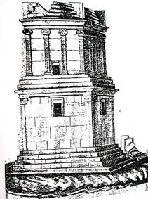
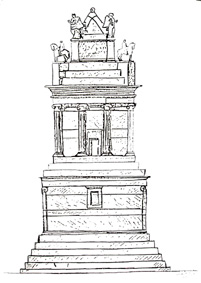
Lemausolée libyco punique (n°54)
Datable du III-II e siècle avant J.-C. et situé au sud-est de la ville, ce mausolée dit aussi d’Atban était vraisemblablement un cénotaphe dédié au roi Massinissa. Il reste du haut de ses 21m, l’un des rares exemples qui subsistent de ce que les spécialistes ont convenu d’appeler «l’architecture royale numide».
 |
Reposant sur un piédestal de cinq gradins, il comprend trois étages:
– un étage inférieur décoré aux angles de pilastres et dans lequel se trouve la chambre funéraire. L’accès à cette dernière se fait par une fenêtre située sur la face nord et qui était fermée par une dalle aujourd’hui disparue. Les trois autres faces sont décorées chacune d’une fenêtre décorative.
– un étage médian qui repose sur trois gradins et composé de trois assises de pierres de taille, d’une architrave et d’une gorge égyptienne. Il est décoré de colonnes ioniques cannelées. Sur les faces nord et est se trouvent des fenêtres qui étaient fermées par des dalles.
– Un étage supérieur reposant sur des gradins interrompus aux angles par des piédestaux décorés par des figures de cavaliers. Un bas-relief qui représente un quadrige monté par deux personnages est figuré sur chacune de ses faces. Le monument est couronné d’un pyramidion flanqué aux angles de quatre statues de femmes ailées et surmonté d’une statue de lion assis sur ses pattes arrières.
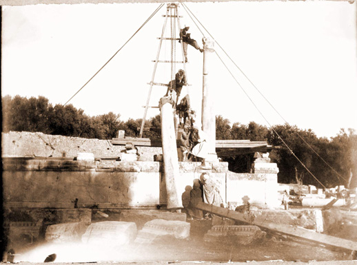
En 1842, ce monument a été presque totalement démoli par Thomas Read alors consul d’Angleterre à Tunis dans le but de s’emparer de la célèbre inscription bilingue en libyque et en punique qui se trouvait à gauche de la fenêtre de l’étage inférieur et qui est conservée aujourd’hui au British Museum à Londres.
Grâce aux travaux de restauration réalisés entre les années 1908-1910, le mausolée fut remis en état. Mais avant la restauration, il a fait l’objet de plusieurs croquis des différentes faces réalisés par différents explorateurs. Le plus ancien est celui de Bruce datant de 1765 et schématise les faces nord et est des étages inférieur et médian. Vient après celui du Comte Borgia daté de 1815 qui dessine les faces sud et ouest des mêmes étages. En 1885, Henri Saladin a reproduit la face sud du monument avec ses trois étages en essayant de restituer surtout le décor.
 |
 |
 |
Vestiges romains
|
 |
 |
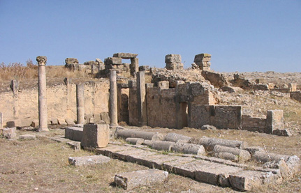
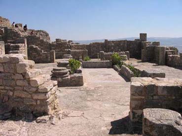
- Place de la Rose des Vents ( n°9 sur le plan ci-dessus)
Cette place était appelée à l’époque romaine area macelli, « place du marché ». Son dallage porte le dessin gravé d’une grande Rose des Vents, un cadran solaire avec l’indication des 12 vents, qui est à l’origine du nom actuel donné à la place. Elle est de plan inhabituel. En effet, le portique qui la borde sur le côté Est au lieu d’être rectiligne, est en hémicycle afin de masquer la ligne oblique de la façade du temple de la Fortune qui, antérieur à la place, s’intégrait mal au nouvel ensemble. Elle a été aménagée très probablement aux frais des Pacuvii, les donateurs des deux monuments qui la bordent au nord et au sud, à savoir le temple de Mercure et le marché.
 |
 |
- Temple de Mercure (n°10)
C’est le temple du dieu protecteur du commerce et des commerçants. Il se trouve au nord de la Place de la Rose des Vents, juxtaposé au mur est du Capitole et faisant face au marché. Il a été construit sous le règne de Commode (180-193 après J.-C.) aux frais de Quintus Pacuvius Saturus et sa femme Nahania Victoria en exécution du testament de leur fils, soldat mort sous les armes. L’accès se fait par un escalier de quatre marches donnant sur un portique de dix colonnes au-delà duquel se trouvent trois salles cultuelles. Celle du milieu, la plus grande, est de forme rectangulaire; les deux autres étant de forme semi-circulaire. Dans la cella orientale on a découvert des sarcophages qui y furent placés à basse époque ainsi que des éléments appartenant à une huilerie d’époque vandale.
 |
- Le marché (n°11)
Ce macellumse trouve au sud de la place de la Rose des Vents. Il est l’un des plus anciens marchés de l’Afrique romaine. Il a été construit entre le 25 Janvier et le 13 Octobre 54 après J.-C. aux frais de Marcus Licinius Rufus, riche et puissant patron du pagus de Thugga. Il a été rasé presque complètement lors de la construction du fortin byzantin. Précédé d’un portique offert par les donateurs du temple de Mercure, il est composé d’une cour à ciel ouvert bordée à l’est et à l’ouest par dix boutiques sur chaque côté. Le côté sud est occupé par une abside qui a perdu aujourd’hui son sol et qui devait abriter la statue de Mercure « génie du marché » (genius macelli).
 |
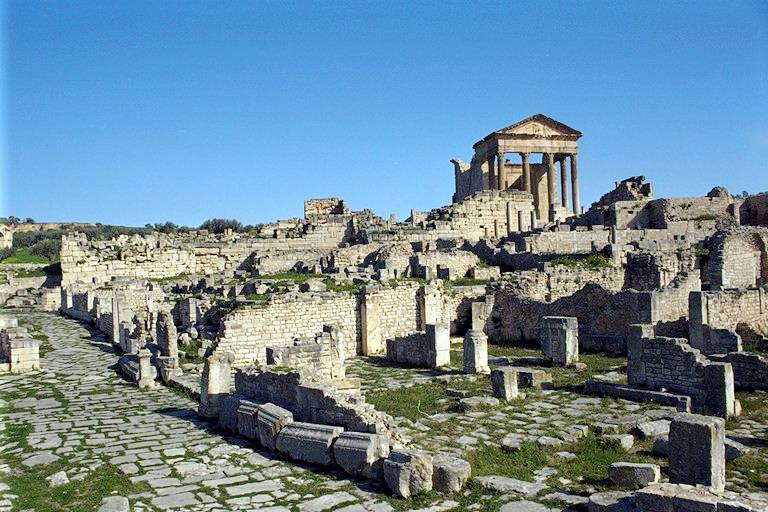
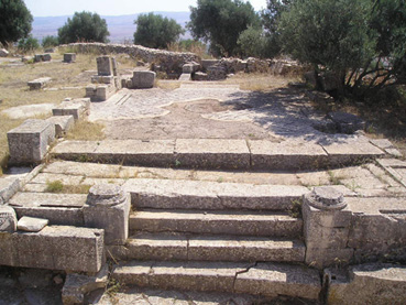
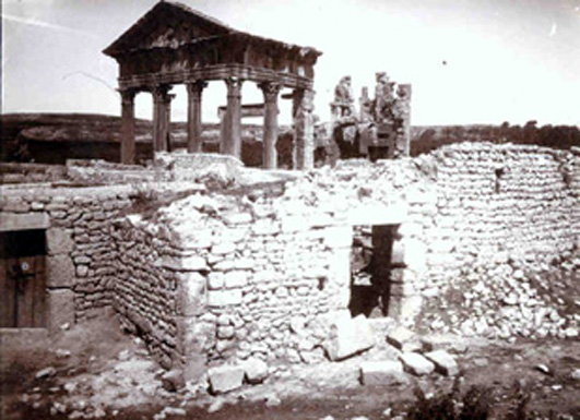
- Le Capitole (n°12)
C’est le temple consacré au culte de la triade protectrice de Rome: Jupiter, Junon et Minerve. Il a été construit aux frais de Lucius Marcius Simplex et de son fils Lucius Marcius Simplex Regillianus en 166 ou 167 après J.-C. Il est précédé d’une plate-forme dallée qui lui servait de cour pour les fidèles.
L’accès se fait par un escalier qui donne sur un portique formé de quatre colonnes en façade et deux colonnes en retour. Au-delà se trouve la salle cultuelle, grande pièce rectangulaire (13m x 14m), dont le fond est décoré de trois niches. La plus haute, au milieu, contenait une statue colossale de Jupiter assis; les deux autres celles de Junon et de Minerve. Le tympan du fronton est orné d’un relief représentant un homme emporté par un aigle, symbolisant l’apothéose de l’empereur Antonin le Pieux (138-161 après J.-C.).
 |
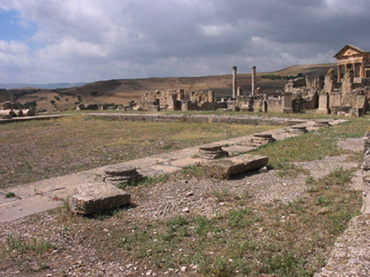
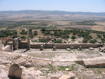
- Le forum (n°13)
D’assez faibles dimensions (38,5m x 24m), ce forum est une place entourée de portiques sur trois côtés. Elle fut dallée au cours de la dernière année du règne de Tibère (14-37 après J.-C.) aux frais d’un riche membre du pagus. C’était le centre de la vie publique et administrative de la cité. C’est là que la cité par l’érection de statues, honorait ses fils méritant et rendait hommage aux gouvernants.
 |
-
- Les temples
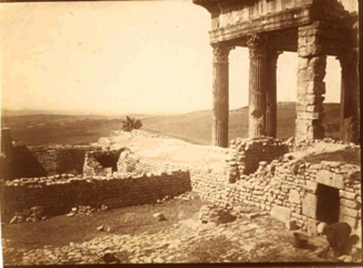
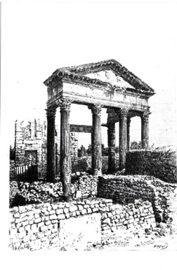
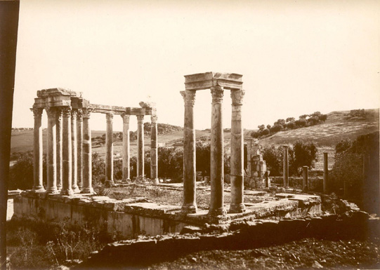
Temple de Baal Hamon-Saturne (n°1)
Ce temple consacré au dieu suprême de l’Afrique antique occupe une plate-forme au nord-est du site. Construit en 195 après J.-C., sous le règne conjoint des empereurs Septime Sévère et Clodius Albinus, il est orienté à l’est et composé de trois parties:
- un vestibule
- une cour à ciel ouvert entourée de portiques
- et trois salles (cellae) qui contenaient la ou les statues divines et les objets cultuels.
 |
 |
 |
- Temple de Neptune? (n°2)
- Temple de la Piété Auguste (n°7)
 |
 |
- Temple de Fortune Auguste, Vénus Concorde et Mercure Auguste (n°8)
- Temple de Mercure (n°10)
- Le Capitole (n°11)
- La chapelle païenne (n°15)
 |
 |
- Temple de Tellus (n°18)
 |
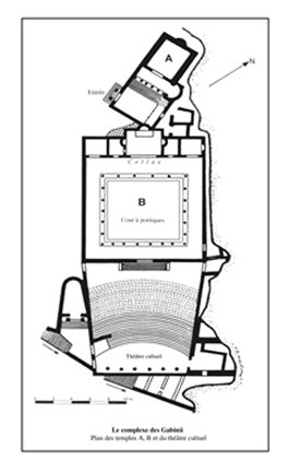
- Complexe cultuel des Gabinii (n°22)
Ce complexe est composé de deux temples (A et B) dédiés à la Concorde, à Frugifer et à Liber Pater. La construction a été réalisée sur le terrain et aux frais de Aulus Gabinius Datus et de son fils Marcus Gabinius Bassus. Ce complexe est situé au sud-est du forum et au nord des thermes de Caracalla.
- Temple A:
 |
C’est un édifice composé d’une cella précédée d’un pronaos, construite sur un haut podium et à laquelle on accède par un escalier de sept marches après avoir traversé une petite cour.
- Temple B:
Il s’agit d’un temple constitué d’une grande area entourée de portiques et cinq cellae qui ouvrent sur la galerie nord. La cella centrale, plus grande que les autres, se termine par une abside où devait se trouver la statue cultuelle.
 |
 |
- Sanctuaire anonyme III (n°23)
D’orientation sud, ce petit sanctuaire a été aménagé dans l’espace resté libre entre les thermes de Caracalla et le théâtre cultuel.
L’accès se fait par un escalier de quatre marches donnant sur un pronaos orné de deux colonnes et qui précède une salle cultuelle de plan trapézoïdale avec une abside percée dans son mur de fond pour abriter la statue de la divinité.
- Sanctuaire de Minerve (n°28)
 |
- Sanctuaire de Minerve II (n°39)
Ce temple a été construit sous le règne de l’empereur Antonin le Pieux (138-161 après J.-C.) aux frais de la prêtresse du culte impérial Iulia Paula Laenatiana.
Orienté au sud-est, il est composé d’une grande cour rectangulaire entourée de portiques sur trois côtés et d’une cella qui était précédée d’un portique aujourd’hui disparu. La cella à laquelle on accède par un escalier monumental est érigée sur un haut podium dont l’intérieur est aménagé en salles dans lesquelles on pouvait entrer par des portes latérales.
 |
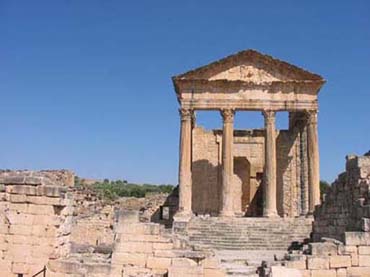
- Temple Anonyme I (n°30)
Situé au sud-ouest du forum, ce monument plus connu sous le nom de Dar Lachheb (=la maison de Lachheb) a été construit en 164-166 après J.-C. sous le règne conjoint des empereurs Marc-Aurèle et Lucius Verus.
L’entrée se fait par une porte encore aujourd’hui dans un excellent état de conservation ouvrant sur une grande cour rectangulaire bordée de portiques sur chacun de ses longs côtés. Cette cour serait l’area d’un temple dont la cella située au sud a disparu.
 |
- Temple des Victoires de Caracalla (n°32)
Situé dans le quartier au sud-ouest du forum et à peu de distance à l’ouest du temple anonyme dit Dar Lachheb, ce sanctuaire a été érigé sur un terrain de forte déclivité ce qui a nécessité d’importants travaux de terrassement. Il est limité à l’est par la maison dite de Vénus et à l’ouest par une rue qui descend vers le quartier des thermes de Aïn Doura.
Orienté à l’ouest, il est de dimensions relativement importantes: 41,50m de long et 14, 20 m de large. C’est un temple sur podium, bâti au fond d’une cour dont il occupe la largeur.
L’accès se fait par une porte latérale percée près de son angle ouest et à laquelle on arrive par un escalier de trois marches donnant sur une grande cour dallée. Cette dernière est surplombée au nord par une grande salle rectangulaire, cella, précédée d’un portique et à laquelle on accède par un escalier monumental.
- Temple de Junon Caelestis (n°34)
- Temple du dieu Sol (n°43)
C’est un petit sanctuaire de plan quadrangulaire. Il donne sur la rue antique qui reliait le quartier des citernes de Aïn Mizeb et du temple de Minerve II à la rue du temple de la Piété Auguste.
Consacré au culte du dieu Soleil, il a été construit (ou plus probablement restauré) à la fin du IIIe siècle après J.-C.
Orienté à l’ouest, on y accède par un escalier de quatre marches qui donne sur un vestibule peu profond précédant la salle cultuelle.
Un podium en partie encastré dans le mur de fond de la cella et que devait surmonter partiellement une niche aujourd’hui disparue, servait de socle à la statue de la divinité.
 |
- Temple anonyme IV (n°44)
Ce sanctuaire est situé au nord du temple de Mercure. Orienté à l’ouest, il est construit sur podium. L’accès se fait par un escalier de huit marches débouchant sur un pronaos peu profond. La cella très ruinée avait un plan carré.
 |
- Temple anonyme dit de Pluton (n°50)
Suite à la découverte lors de la fouille du monument d’un buste de Pluton, dieu poliade de Thugga et son génie protecteur, il a été proposé à titre de simple hypothèse-de reconnaître dans cet édifice un temple de cette divinité.
 |
- Temple anonyme II (n°52)
Situé à peu de distance au nord du mausolée punico-libyque, ce sanctuaire a été édifié sur un terrain qui était occupé par des sépultures d’époque numide.
Il est orienté à l’est et son plan est irrégulier. Il est constitué d’une cour entourée de portiques sur trois côtés et d’un petit sanctuaire sur podium occupant le côté ouest.
 |
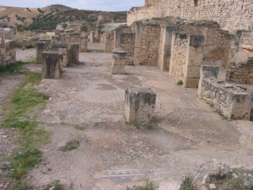
- Les maisons
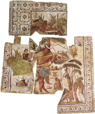
À ce jour, le nombre des maisons identifiées s’élève à 12. À l’exception de deux demeures: la maison des Escaliers et la maison du Trifolium, toutes les autres doivent leurs noms actuels aux thèmes des mosaïques couvrant le sol de l’une des chambres, ou de la cour, du vestibule, ou encore d’un bassin…
Elles constituent d’une part un ensemble archéologique exceptionnel par la variété de leurs plans et de leurs caractéristiques architecturales. Elles ont fourni, d’autre part, un riche dossier iconographique composé de mosaïques à thèmes très variés.
- Maison des Échansons (n°19)
Cette demeure est située à l’est du marché. L’entrée se fait par la rue des thermes de Caracalla. Elle est constituée d’une petite cour pavée de mosaïque à décor géométrique sur laquelle donnent les différentes pièces dont l’une avait le sol orné avec une mosaïque datable du IIIe siècle après J.-C. et qui figure deux échansons de grande taille portant sur l’épaule des amphores dont ils font couler le vin dans des coupes que leur présentent deux clients. Sur l’amphore de l’échanson de droite, ornée de feuilles de lierre, est écrit, en caractères latins, le mot grec PIE (bois). Sur celle de l’échanson de gauche est écrit en grec ZHCHC (tu vivras): il s’agit là de deux souhaits qui se complètent «Bois et tu vivras». À gauche et à droite de la mosaïque, deux jeunes serviteurs apportent aux buveurs, l’un, une corbeille de fleurs, l’autre, une petite amphore contenant du parfum et une serviette. Cette mosaïque est aujourd’hui exposée au Musée National du Bardo à Tunis.
- Maison des Escaliers (n°20)
Située au sud-est du marché, cette maison donne comme la précédente sur la rue des thermes de Caracalla. Elle est construite sur un terrain accidenté de forte déclivité, ce qui a rendu nécessaire l’aménagement de nombreux escaliers pour pouvoir circuler entre les différents niveaux.
Le centre de la maison est nettement en contrebas du reste. Il est constitué par une petite cour bordée de portiques sur deux côtés. Au centre, un petit patio rectangulaire est bordé à l’ouest par trois pièces que séparaient de minces cloisons. Tandis qu’à l’est, il est bordé par un petit portique.
 |
Sur la travée ouest du portique, donnent deux petits escaliers qui montaient aux chambres nord et ouest de l’étage.
Quant à la partie nord de la demeure qui est desservie par un vestibule donnant sur la rue, elle est très endommagée et semble avoir été très remaniée.
 |
Au sud-est de la maison, se trouvent d’autres pièces qui étaient séparées d’elle par un mur épais et qui étaient selon toute vraisemblance des boutiques.
- Maison du Labyrinthe (n°24)
 |
- Maison des trois masques (n°25)
Cette demeure doit son nom à une mosaïque qui tapissait le sol de l’une des chambres et qui figure dans des médaillons, trois masques dont deux de Bacchante et un de Silène. Datable du IIIe siècle après J.-C., cette mosaïque est exposée aujourd’hui au Musée National du Bardo.
Située en contre-bas de la maison du Labyrinthe, elle a un plan complexe, fruit de sa longue histoire et des nombreuses modifications apportées: la partie centrale de la maison est occupée par une enfilade de pièces qui n’étaient séparées que par de minces cloisons.
 |
-
- Maison de Dionysos et d’Ulysse (n°26)
 |
|
 |
-
- Maison «Omnia tibi felicia» (Que tout te porte bonheur) (n°27)
 |
|
Située au sud des thermes de Caracalla, l’accès à cette maison se fait par la rue du temple Anonyme dit de Dar Lachheb.
Elle doit son nom à la formule de bienvenue Omnia tibi felici (Que tout te porte bonheur) qui figure sur la mosaïque du vestibule datable du IV e siècle après J.-C. et exposée aujourd’hui au Musée National du Bardo.
La maison est composée d’une petite cour à portique dont le sous-sol est occupé par une citerne. Les côtés nord, ouest et est sont occupés par différentes pièces de dimensions modestes qui prennent le jour sur le péristyle.
 |
- Maison de Marsyas (n°29)
Située au sud-est du temple Anonyme dit de Dar Lachheb, cette maison de dimensions modestes est composée de trois pièces. Elle doit son nom à la mosaïque qui ornait le sol de l’une de ses pièces. Cette mosaïque qui se trouve aujourd’hui dans les réserves du site, figure les différents épisodes du fameux mythe du berger Marsyas qui a osé défier dans un concours le dieu de la musique Apollon: la découverte de la double flûte par la déesse Athéna et sa surprise par Marsyas, la joute musicale entre Apollon et Marsyas et le châtiment du berger.
 |
- Maison de Vénus (n°31)
Il s’agit d’une maison mitoyenne du temple des Victoires de Caracalla. Elle doit son nom à une mosaïque qui décore le fond d’un bassin figurant Vénus et les Amours dans une ambiance marine.
L’accès se fait par la rue qui sépare la maison à l’est du temple Anonyme. La partie fouillée jusqu’ici est constituée d’une série de pièces dont un triclinium, salle à manger et un cubiculum, chambre à coucher ayant pour la plupart des sols composés de mosaïques à décor végétalisé.
Cette maison a connu de nombreux réaménagements témoins de la longue période de son occupation qui s’est poursuivie du II e siècle après J.-C. au plus tard jusqu’au V e siècle après J.-C.
 |
- Maison du canard et des saisons (n°46)
Située dans la zone sud-est du site, cette maison datable du III e siècle est construite sur un terrain de forte déclivité.
Elle est composée de deux étages:
- un étage supérieur ouvrant sur la rue qui descendait du théâtre et menait vers la maison du trifolium et le mausolée numide.
- et l’autre sur celle qui longe le temple dit de Pluton et rejoint celle de l’arc de Septime Sévère.
Le passage de l’un à l’autre se faisait par des escaliers et un entresol.
La maison doit son nom à deux mosaïques, l’une découverte à l’étage supérieur figurant un canard et l’autre trouvée à l’étage inférieur représentant un Génie de l’abondance entouré des quatre Saisons.
 |
- Maison du Trifolium (n°47)
Située dans le quartier sud du site, cette demeure est à ce jour, la plus grande des maisons fouillées à Dougga. Elle se compose d’un rez-de-chaussée dont il ne subsiste que peu de chose et d’un étage inférieur.
 |
Précédée d’un porche à deux colonnes empiétant sur la rue, l’entrée de la maison donne sur un vestibule d’où part un escalier descendant à l’étage inférieur. Celui-ci est organisé autour d’une grande cour entourée d’un portique et dont le centre est occupé par un jardin.
 |
Sur la galerie ouest ouvrent les trois portes de la grande pièce de la maison, l’oecus, qui donne au nord sur une autre grande pièce dont le plan affecte une forme tréflée.
 |
Sur les galeries sud et est prennent jour des chambres plus petites. Le long de la galerie est du portique se trouve une citerne sur le côté de laquelle est ménagée une petite fontaine.
 |
- Maison de la Gorgone (n°51)
Cette maison est située au sud-est de la ville. L’entrée principale est marquée par un porche. Elle est construite sur de vastes sous-sols qui prenaient le jour par des soupiraux placés au niveau de la rue. On y accédait par une porte située dans la partie sud-est de la maison.
Quant au vestibule, il repose sur une citerne dont les voûtes sont soutenues par deux rangées de trois piliers.
La demeure doit son nom à la mosaïque de ce vestibule conservée aujourd’hui au Musée National du Bardo et qui figure dans un médaillon central Persée brandissant la tête de Méduse.
 |
 |
- Maison d’Eros et Psyché (n°57)
Cette maison contiguë aux thermes de Aïn Doura n’a pas encore été fouillée en totalité. À ce jour, la partie dégagée est constituée d’une cour à portiques sur laquelle donnent différentes pièces dont deux chambres à coucher, cubicula.
La cour présente les grands traits de l’atrium italique: des colonnes entourant un impluvium, bassin.
La demeure doit son nom à une mosaïque qui orne le sol de l’impluvium et qui figure des Amours pêcheurs et Eros et Psyché représentés dans une barque: une fois l’un en musicien jouant de la flûte et battant du pied la mesure et l’autre en danseuse en fête, et l’autre fois les deux assis avec une table de jeux sur les genoux.
Sur la paroi ouest de la maison d’importants restes de panneaux de peinture sont encore visibles.
- Les installations hydrauliques
Le site de Dougga conserve une riche typologie de l’architecture hydraulique qui est constituée de bains publics, fontaines monumentales, nymphées, latrines publiques, citernes et aqueducs.
Même si certains d’entre eux restent encore à fouiller, ces monuments peuvent être considérés parmi les mieux conservés au Maghreb.
- Thermes de Caracalla (n°21)
- Thermes des Cyclopes (n°48)
- Nymphée de Terentius (n°33)
Dominant une petite place triangulaire au bord de la rue du temple anonyme dit de Dar Lachheb, cette fontaine monumentale est à bouches multiples disposées en segment de cercle comme en témoigne la frise qui l’ornait et qui porte la dédicace du grand aqueduc de Aïn-El-Hammam et de ce nymphée. Ce monument fait partie d’un ensemble hydraulique qui a été réalisé aux frais de la civitas Aurelia de Thugga sous le proconsulat de Marcus Antonius Zeno entre 184 et 187 après J.-C.
L’eau qui alimentait ce nymphée devait provenir par une canalisation qui part des grandes citernes de Aïn-El-Hammam, point d’arrivée de l’aqueduc, jusqu’au réservoir aménagé derrière la fontaine
 |
- Fontaine (n°6)
Située en bordure de la rue du temple de la Piété Auguste reliant la zone du théâtre au quartier du forum, cette fontaine est de forme rectangulaire. Elle consiste en un massif de maçonnerie présentant une façade monumentale ornée de deux niches de forme semi-circulaire où l’eau devait tomber en cascade. Derrière chaque niche était aménagé un réservoir d’eau de forme carrée.
 |
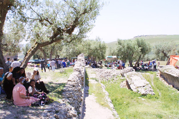
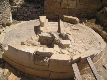
- Citernes de Aïn-El-Hammam (n°35)
Situées dans la partie ouest du site, à l’ouest de l’arc de Sévère Alexandre et au nord-est du temple de Caelestis, ces citernes sont d’une capacité d’environ 6000m3. Elles étaient approvisionnées par l’eau qui arrivait par un aqueduc de la source d’Aïn-El-Hammam située à plus de 12 Km à l’ouest de la cité. Elles sont composées de cinq réservoirs longs chacun de 34m et larges de 5m. Un sixième compartiment placé perpendiculairement servait de bassin de décantation.
C’est ici que chaque année au printemps les Dougguis se réunissent pour organiser la «zarda» annuelle de leur sainte patronne Mokhôla. (Hyper lien Mokhôla)
 |
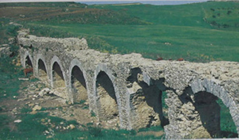
- Aqueduc de Aïn-El-Hammam (n°36)
Cet aqueduc est l’un des mieux conservés de Tunisie. Dédié pour la sauvegarde de l’empereur Commode, il a été construit aux frais de la civitas Aurelia Thugga sous le proconsulat de Marcus Antonius Zeno: 184-187 après J.-C et fut l’objet d’une importante restauration comme le fait connaître une longue dédicace datée de l’année 376 après J.-C.
Son point de départ est situé dans le massif montagneux de Jbel Fej el Hdoum et Jbel Bou Khoubaza au sud-ouest de Thugga et à une distance à vol d’oiseau de 8500m.
Un bassin carré de 10m de côté a été construit pour capter les eaux tièdes de la source de Aïn-El-Hammam avant d’être acheminées par la suite au moyen d’un aqueduc souterrain sur la plus grande partie de son parcours jusqu’aux citernes de Aïn-El-Hammam.
 |
- Citernes de Aïn Mizeb (n°38)
De contenance totale d’environ 9000m3, ces citernes constituaient une importante réserve d’eau pour l’approvisionnement de la cité.
Elles se composent de sept réservoirs accolés qui ont été construits en deux temps et qui sont longs chacun de 35m et larges de 5m. un huitième compartiment placé perpendiculairement aux autres servait de bassin d’arrivée à l’aqueduc.
L’eau arrivait de la source de Aïn Mizeb située à environ 200m au nord-ouest des citernes au moyen d’un aqueduc souterrain haut de 1,60m et large de 0,50m. Cette source est encore en service aujourd’hui.
 |
- La fontaine conique (n°45)
Cette fontaine est située sur le côté gauche de la rue qui mène à l’arc de Sévère Alexandre, au carrefour le plu passant de la cité: là où se croisaient pas moins de sept rues venant de toutes les directions.
Elle est entourée d’un mur semi-circulaire et composée d’un bassin hexagonal où l’eau retombait le long d’un massif conique haut de plusieurs mètres qui en occupait le centre.
- Le grand nymphée (n°55)
Situé à l’ouest de la maison du trifolium, ce grand nymphée partiellement fouillé est une sorte de grande exèdre voûtée de 8, 70m d’ouverture. Il était alimenté par l’eau qui devait provenir des citernes de Aïn-El-Hammam par une conduite souterraine dont aucune trace n’a encore été retrouvée.
À la naissance de la voûte, l’abside est ornée d’une corniche qui supportait un canal où passait l’eau amenée par un conduit ménagé dans le mur de fond. Un puisard était adossé au mur extérieur de l’abside.
- Complexe thermal de Aïn DouraThermes de Aïn Doura (n°58)
(Hyper lien m. de loisirs)
- Citernes de Aïn Doura (n°56)
(Hyper lien m. de loisirs)
- Latrines des thermes de Aïn Doura (n°59)
(Hyper lien m. de loisirs)
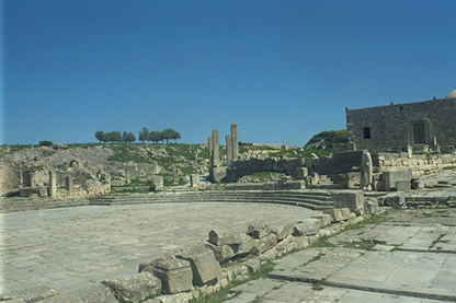
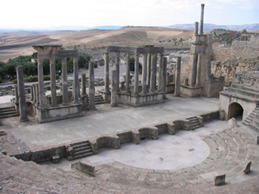
- Les monuments de loisirsLe théâtre (n°5)
D’une capacité d’environ 3500 places, cet édifice est l’un des plus spectaculaire de Dougga et l’un des théâtres les mieux conservés du Maghreb. En l’honneur de son flaminat perpétuel, un riche citoyen de Thugga, le flamine du culte impérial Publius Marcius Quadratus, a construit àses frais ce monument en 168 ou 169 après J.-C. sous le règne conjoint des empereurs Marc-Aurèle et Lucius Verus.Situé aunord-est de la ville, ses dispositions sont celles des théâtres d’époque romaine:
- une cavea
- un orchestre
- et une scène
La cavea où se tiennent les spectateurs est adossée en grande partie au rocher. Elle est formée de 19 gradins divisés en 3 étages par des galeries de circulation. À leur tour, les étages sont divisés en travées par des escaliers rayonnant autour de l’orchestre qui est séparé de la scène par un mur haut de 1 mètre environ et décoré de niches alternativement rectangulaires et semi-circulaires. Deux escaliers adossés à ce mur permettent de passer de l’orchestre à la scène.
 |
 |
- Le cirque(n°40)
Ce monument a été édifié en 224 après J.-C. sur un terrain situé au nord-ouest de la ville qui a été offert en 214 après J.-C., par une riche citoyenne, Gabinia Hermiona, comme nous l’apprend sa dédicace:
«G[a]binia Hermiona…dans son testament, a prescrit…et le terrain nommé “le cirque”, elle l’a légué à la république pour les plaisirs du peuple.»
Long de 393m et avec une spina (murette ou simple levée de terre autour de la quelle courait la piste) longue de 190m et large de 6m le circus de Thugga paraît bien modeste comparé au circus maximus à Rome long de 600m ou même à celui de Carthage long de 570m.
- Le théâtre cultuel (n°22)
 |
C’est un petit théâtre cultuel où devaient se dérouler les cérémonies liées au culte de Liber Pater. Il est situé en contre-bas des temples de la Concorde, de Frugifer et de Liber Pater. L’accès se fait par une porte aménagée dans le mur du temple B du complexe cultuel qu’on des Gabinii. La porte donnait accès à un escalier aujourd’hui disparu qui descendait vers la galerie supérieure de la cavea.
Cet édifice ne possède pas de scène mais un grand orchestre qui a la forme d’un segment de cercle.
 |
Des niveaux d’habitat d’époque numide ont été reconnus sous les gradins de la cavea au cours des travaux de restauration et de valorisation de cet édifice. Ils viennent corroborer les informations fournies par l’épigraphie qui faisaient connaître que le terrain sur lequel cet ensemble a été édifié appartenait à une famille d’origine autochtone et devait donc être déjà urbanisé depuis l’époque numide.
 |
- Thermes des Cyclopes (n°48)
Il s’agit d’un monument qui tire son nom actuel du pavement de mosaïque qui tapissait le sol du frigidarium (salle de bain froid). Elle est datable du premier quart du IIIe siècle après J.-C. et se trouve exposée aujourd’hui au Musée National du Bardo. Elle figure les Cyclopes forgeant les foudres de Jupiter dans l’antre de Vulcain.
L’accès se fait par une grande porte donnant sur la rue et qui ouvre sur un long couloir qui longe deux grandes citernes pour aboutir au frigidarium. Cette salle se prolonge à l’est par une piscine rectangulaire qui se termine par une exèdre.
 |
À gauche de cette porte se trouvent des latrines publiques constituées d’un grand banc de pierre de forme presque semi-circulaire comportant douze sièges. Au pied du banc court une rigole creusée dans le dallage qui amenait l’eau nécessaire à la toilette intime.
Face aux sièges et adossée au mur de la citerne se trouve une petite vasque qui recevait l’eau provenant des grandes citernes situées de l’autre côté du mur.
- Les thermes de Caracalla (n°21)
-
Cet établissement est situé au sud-est du quartier du forum. De plan symétrique, il a été construit sous le règne de l’empereur Caracalla (212-217 après J.-C.). De par son ampleur, il est classé parmi les plus grands thermes du Maghreb.
L’accès se fait par une porte d’entrée qui donne sur l’atrium. De là un grand escalier de 24 marches mène à une grande salle d’entrée de laquelle on accède aux différentes salles des thermes: vestibules, apodytherium (vestiaire), frigidarium (salle de bains froids), elæothesium (salle de dépôt d’huile et de massage) palestre (espace de culture physique), sudatoria (deux étuves humides qui activaient la transpiration), laconica (deux étuves sèches), caldaria (trois salles de bains chauds) et un tepidarium (salle de bains tièdes).
Un souterrain de service est aménagé au-dessous des salles chaudes.
 |
 |
- Complexe thermal de Aïn Doura
Tirant son nom de celui d’une source voisine et situé dans le quartier sud-ouest du site, ce complexe thermal est constitué de trois grandes composantes:
- l’établissement thermal proprement dit.
- les latrines
- les citernes
- Les thermes (n°58)
De plan en forme de T renversé, l’établissement thermal est édifié sur un terrain en pente assez accusée ce qui a nécessité d’importants travaux de terrassement. À ce jour, c’est seulement la partie est du monument qui a été fouillée. On a identifié jusqu’ici:
- le frigidarium, salle de bains froids qui est flanquée de quatre piscines
- le tepidarium de sortie
- trois salles chauffées situées dans le même alignement que le tepidarium
- et quelques salles de service.
 |
- Les latrines (n°59)
Elles se trouvent au sud-ouest de l’établissement. Leur plan est semi-circulaire. Elles ont 25,70m de diamètre. Les sièges aujourd’hui disparus étaient adossés au mur semi-circulaire et abrités par un portique arrondi.
Ces latrines sont considérées jusqu’ici comme le plus grand monument du genre jamais découvert à Dougga.
 |
- Les citernes (n°56)
Surplombant l’édifice thermal, ces citernes sont composées de trois compartiments séparés par deux rangées de quatre arcades chacune. Ce réservoir long de 28, 50 m et large de 25m, est d’une capacité d’environ 3000m3.
 |
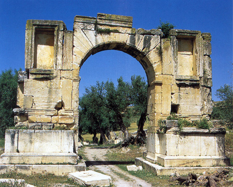
- Arcs Arc de Sévère Alexandre (n°37)
Dédié à l’empereur Sévère Alexandre (222-235 après J.-C.) en commémoration de privilèges accordés au municipe de Thugga, cet arc est situé à l’ouest du site près des citernes de Aïn-El-Hammam. Il est constitué d’une arcade de quatre mètres d’ouverture soutenue par deux pieds-droits décorés sur leurs faces antérieures et postérieures de niches rectangulaires peu profondes.
 |
- Arc de Septime Sévère (n°49)
Situé à la lisière est du site, il a été construit à l’occasion de la promotion de Thugga au rang de municipe, en 205 après J-C.
Il est formé d’une arcade de cinq mètres d’ouverture soutenue par des pieds-droits décorés sur leurs faces antérieures et postérieurs de niches rectangulaires peu profondes.
Une inscription était gravée sur chacune des faces de l’attique en l’honneur l’une de l’empereur Septime Sévère et de son épouse Julia Domna, l’autre de leurs deux fils Caracalla et Géta.
De l’arc partait une voie qui descendait vers la vallée pour rejoindre la grande route qui reliait Carthage à Theveste, aujourd’hui Tébessa en Algérie.
Un autre arc, dont rien ne subsiste fut érigé à la fin du III e siècle après J.-C. au croisement de ces deux voies en l’honneur des empereurs de la Tétrarchie.
 |
Vestiges tardifs
|
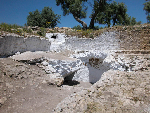
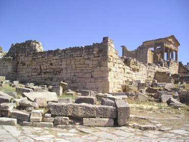
La fortification byzantine (n°16)
Situé au cœur du site, ce fortin a englobé le forum et le temple du Capitole. Il fut érigé sur ordre du généralissime Solomon au II e quart du VIe siècle après J.-C.
 |
 |
De forme rectangulaire avec une tour rectangulaire qui fait saillie sur la face nord et un petit bastion rectangulaire sur la face sud, le fortin était doté d’une porte au sud et d’une poterne au nord. Il a été construit avec des matériaux de remploi pris dans les monuments voisins et même relativement éloignés. Il devait avoir l’intérieur remblayé jusqu’au niveau des portes.
Ce fortin semble avoir été plus destiné à servir de refuge à la population civile que de camp à une armée chargée d’assurer la surveillance et la sécurité de la région.
Des restes d’une enceinte tardive sont encore visibles sur de longues distances et en de nombreux endroits du site. Elle englobe les parties nord et est de la ville en partant de l’angle nord-est du fortin vers la nécropole numide et la zone à l’est du théâtre jusqu’au quartier bas.
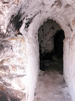
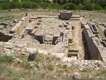
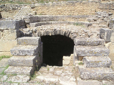
L’Hypogée (n°4)
Situé au nord-est de la ville et au sud du temple de Baal Hamon-Saturne, cet hypogée de plan rectangulaire est à semi enterré. Il s’agit d’un caveau familial qui avait connu tour à tour l’usage de deux rites funéraires: l’incinération puis l’inhumation. Un escalier de sept marches permet de descendre jusqu’à une porte qui donne accès à l’intérieur d’une salle presque carrée qui sert de chambre sépulcrale.
Dans la paroi du fond ainsi que dans les murs latéraux sont creusées des niches destinées à recevoir les urnes cinéraires. De nombreux sarcophages attestent le changement du rite funéraire : de l’incinération à l’inhumation au cours du IVe siècle après J.-C., comme conséquence de la propagation du Christianisme.
 |
 |
Deux mosaïques tombales de deux enfants ont été découvertes dans cet hypogée. L’une porte le nom de l’enfant Vitellius Crispinus et l’autre de Quintus Papirius Fortunatianus Eusebius. Elles sont aujourd’hui exposées au Musée National du Bardo à Tunis.
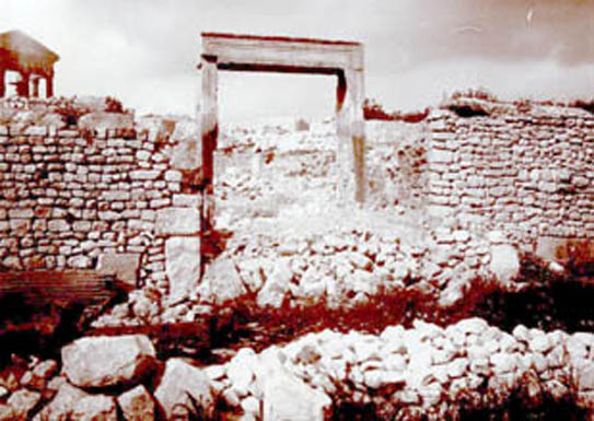
L’église de Victoria (n°3)
Située à quelques mètres à l’est de l’hypogée, cette église martyriale dite de Victoria est le seul édifice de culte chrétien retrouvé jusqu’ici à Dougga.
 |
Datable de la fin du IV-début du Ve siècle après J.-C., elle a été construite par la communauté chrétienne dans un cimetière païen. De plan irrégulier, elle est composée d’un petit vestibule et de trois nefs de dimensions inégales. Dans le prolongement de la nef centrale a été surélevé un presbyterium rectangulaire dont le fond est occupé par une banquette semi-circulaire.
 |
Deux sacristies reliées par deux escaliers de quatre marches à une crypte occupent le prologement des deux nefs latérales.
Des sarcophages placés les uns sur les autres ont été découverts dans la crypte. Un seul d’entre eux porte une épithaphe : celui de la religieuse Victoria.
Exploration et Collection
- Historique de l’exploration du site
A- Le temps des voyageurs:
 |
B- Le temps de l’exploration (1881-1956): mise au jour de la splendeur d’autrefois
- Le temps des dégagements
 |
 |
En 1894, Sadoux et Pradère, alors conservateur du Musée Alaoui (futur Musée National du Bardo) à Tunis, ont débuté les fouilles dans le sanctuaire de Tanit-Caelestis qui ont été poursuivies en 1895 par R. Coudray de la Blanchère (Directeur du Service des Antiquités entre 1893 et 1905) et par Hilaire entre 1896 et 1897.
 |
 |
Entre 1899 et 1900, Carton continua le dégagement des abords du théâtre qui fut entièrement nettoyé vers la fin du XIXe siècle.
- Le temps des fouilles officielles
 |
 |
- La campagne d’Alfred Merlin
 |
- Les campagnes de Louis Poinssot
 |
 |
- Les travaux de restauration et de consolidation
 |
 |
 |
 |
Une série de travaux de restauration a été menée aussi dans le temple de Tanit-Caelestis. Une grande partie des colonnes de la cella et celles du portique ont été remontées en 1904. Le pilier de la porte ouest a été entièrement reconstitué.
 |
 |
Après l’indépendance
Dougga Parc Archéologique National en 1991: une nouvelle phase de sauvegarde et de mise en valeur.
-
-
Le 21 juillet 1991 est désormais pour Dougga une date marquée d’une pierre blanche : ce jour-là, en effet, à Carthage, lors d’un Conseil Ministériel, fut prise la décision d’aménager le site de Dougga en un Parc Archéologique National. Dans ce cadre, un vaste programme d’inventaire et d’étude a été engagé:
1- Le programme PETRAE-Thugga: commencé en 1993, il a consisté en l’inventaire et étude des textes épigraphiques de Thugga. Dans ce cadre, deux importants ouvrages sont parus : Dougga fragments d’histoire. Choix d’innscriptions latines éditées, traduites et commentées (Ie-IVe siècles) en 2000et Mourir à Dougga, Recueil des inscriptions funéraires en 2002. Ce programme a été réalisé en coopération entre l’Institut National du Patrimoine et le centre AUSONIUS de l’université de Bordeaux III. Il a été dirigé par Mustapha Khanoussi, directeur de recherche à l’INP et Louis Maurin, professeur émérite de l’Université de Bordeaux III.
2- Le Programme « Architecture religieuse païenne de Thugga» commencé en 1999 et portant sur l’étude de l’architecture religieuse paîenne de Thugga. Plusieurs édifices religieux sont étudiés dans le cadre de ce projet: le capitole, le temple de Caelestis, le temple de la Victoire Germanique de Caracalla, le temple de Pluton, le temple de Mercure…
Le programme est réalisé en coopération des deux institutions mentionnées ci-dessus et dirigé par Mustapha Khanoussi et J.-Cl. Glovin, directeur de recherche au CNRS.
Dougga, Patrimoine de l’Humanité
-
Témoins de plus de dix-sept siècles de l’histoire d’une petite cité provinciale, les vestiges de Dougga sont, en effet, considérés pour leur diversité et leur beauté, parmi les plus spectaculaires non seulement de Tunisie, mais de tout le Maghreb. Elles sont classées depuis décembre 1997 sur la Liste du Patrimoine Mondial de l’UNESCO.
Dougga fait également partie des cinq sites archéologiques des pays méditérranéens retenus pour le projet euro-méditérranéen PISA, projet pilote de gestion et de valorisation du patrimoine archéologique.
- Collections
Les mosaïques
Les Cyclopes forgeant les foudres de Jupiter
 |
L’aurige vainqueur
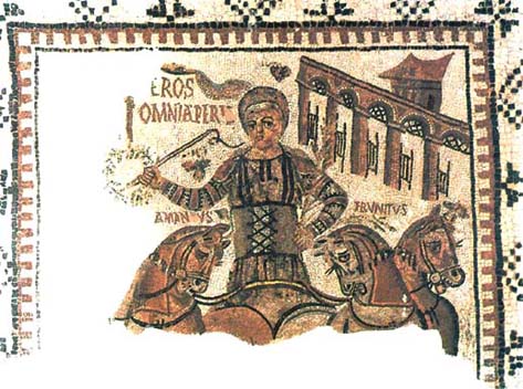 |
Deux des quatre chevaux portent des noms: Amandus et Frunitus (l’Aimable et le Jovial).
En arrière-plan à droite, cinq arcades fermées par des portes battantes à claire-voie figurent les écuries du cirque.
Echansons
 |
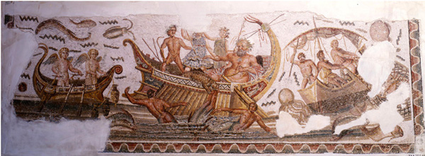
Nageur et Néréides
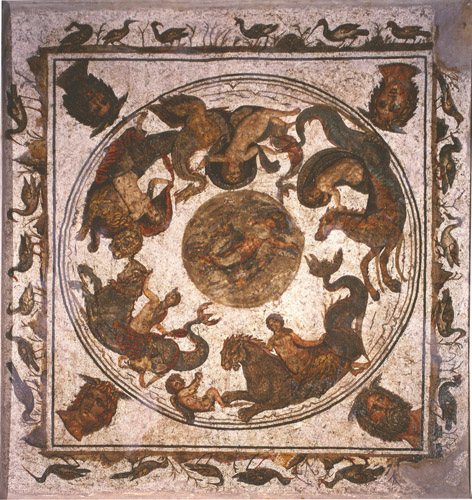 |
Mesurant 3m x 3m, cette mosaïque datable de la fin IIe siècle après J.-C. figure un nageur entouré de cinq Néréides chevauchant des monstres marins. Elle est encadrée par une bordure représentant des oiseaux marchant ou picorant. Les angles du tableau sont occupés par les têtes des quatre Vents.
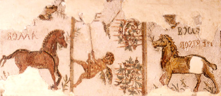
Les quatre factions du cirque
 |
Datable de la deuxième moitié du IVe siècle après J.-C., cette mosaïque est exposée aujourd’hui au Musée National du Bardo.
Mesurant 1.25m x 0.55m, elle représente les chevaux des quatre factions du cirque opposés deux par deux et ayant chacun une palme de victoire. Les coursiers –dont deux sont presque entièrement détruits-sont accompagnés de leurs noms: Derisor et Bocc[hus],Amor et … ri(?).
Des Amours chassant des oiseaux à la glu sont figurés au milieu parmi des plants de vigne dont les branches sont montées sur des cerceaux. Il ne subsiste qu’un des Amours.
Epitaphe de Vitellius Crispinus
Mesurant 1, 10m x 0, 60m, cette mosaïque tombale présente l’épithaphe de l’enfant Vitellius Crispinus mort à huit ans. Découverte dans un hypogée, elle est aujourd’hui exposée au Musée National du Bardo.
Epitaphe de Quintus Papirius Fortunatianus
Découverte dans un hypogée, cette mosaïque tombale d’un enfant est datable du IVe siècle après J.-C. Elle mesure 0, 90m x 1, 90m et représente le défunt assis sur une sorte de coffre suggérant vraisemblablement un sarcophage. Une épitaphe figurée de part et d’autre de la tête du défunt:
D(ii) M(anibus) S(acrum)
Summa(e) bonitatis et ingeni puer, Q(uintus) Papiri(u)s Fortunatianus Eusebius vix(it) an…
Aux dieux Mânes, consécration.
Enfant d’une bonté et d’une intelligence extrêmes, Quintus Papirius Fortunatianus Eusebius a vécu (tant d’années).
Le reste de la mosaïque est occupé par quatre rameaux de roses, d’épis, de pampres et d’olivier, symbolisant les quatre saisons. Elle est aujourd’hui exposée au Musée National du Bardo.
Les trois masques
 |
L’aurige vainqueur en pied
 |
Découverte dans une maison du quartier des thermes de Caracalla, cette mosaïque est exposée aujourd’hui au Musée National du Bardo. Datable de la fin du IV e siècle après J.-C., elle figure dans un médaillon circulaire, un aurige debout de face brandissant de la main droite, un fouet et tenant de la gauche une palme, symbole de victoire. Des rectangles renferment des chevaux d’un quadrige. Ces coursiers ont des formes lourdes et trapues qui les font ressembler à des poneys.
Les Amours
«Que tout te porte bonheur»
Marsyas
 |
Découverte dans la maison dite de Marsyas, cette mosaïque se trouve aujourd’hui dans les réserves du site. Elle figure les différents épisodes de la légende du berger Marsyas qui a osé défier le dieu de la musique Apollon dans un concours : la découverte de la double flûte par la déesse Athéna et sa surprise par Marsyas, la joute musicale entre Apollon et Marsyas et le châtiment du berger. Elle est datable du IV e siècle après J.-C.
Labyrinthe
 |
Découverte dans une maison à laquelle elle a donné son nom, cette mosaïque mesure environ 5m x 5m. Elle figure un dédale géométrique qui évoque le plan du labyrinthe. L’enceinte du monument, rendue de façon conventionnelle, est suggérée par des tours d’angles et des portes fortifiées. Elle est datable du IIIe siècle après J.-C. et exposée aujourd’hui au Musée National du Bardo.
Oiseaux et bouquetins
 |
Masques et colombe blanche
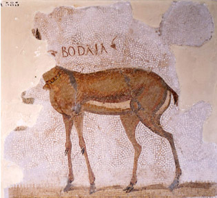
La gazelle Bodala
 |
Dionysos
 |
Oiseau qui picore
 |
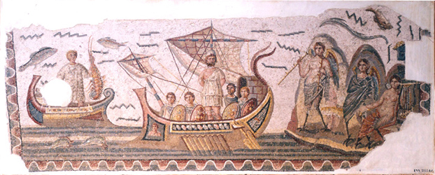
Scènes de pêche
 |
Ulysse résistant au chant des Sirènes
 |
Scènes de pêche
 |
Découverte dans la maison de Dionysos et d’Ulysse, cette mosaïque mesure 3m x 1m, 03.
Un pêcheur fortement musclé est figuré au centre de la mosaïque. Il est en train de pousser dans l’eau une barque à rames sur laquelle se trouve un cordage et une ligne avec hameçon.
Scènes de pêche
 |
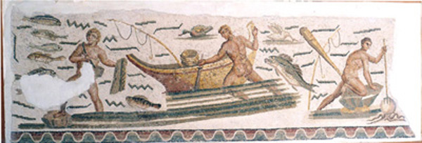
Poissons et crustacés
 |
De forme semi-circulaire, la mosaïque figure des poissons, des crustacés et des mollusques. Elle a été découverte à la maison de Dionysos et d’Ulysse. Mesurant 2m, 65 x 1m, 80, elle est exposée aujourd’hui au Musée National du Bardo. Sa datation remonterait au règne de l’empereur Gallien (260-268 après J.-C.).
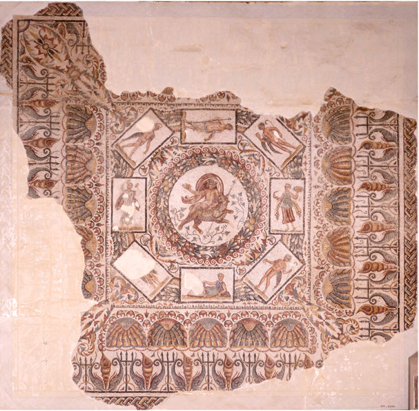
Dionysos et les saisons
 |
Découverte dans la maison de Dionysos et d’Ulysse, cette mosaïque est datable du milieu du IIIe s. après J.-C. Elle mesure 3m, 15 x 3m, 82.
Dans un médaillon circulaire bordé d’une couronne de laurier, elle figure un buste de Dionysos. Tout autour, quatre autres médaillons délimités par des tentures contiennent les bustes féminins des Saisons la tête couronnée d’attributs végétaux caractéristiques.
La mosaïque est aujourd’hui exposée au Musée National du Bardo.
Un musée de plein air
|
 |
 |
Bibliographie
- 1) Sources littéraires:
- 2) Atlas
- 3) Recueils épigraphiques
- 4) Récits de voyageurs:
- 5) Commentateurs de récits de voyageurs:
- 6) Ouvrages et articles
- 7) Mémoires et thèses inédits
1) Sources littéraires:
- Diodore de Sicile,Bibliothèque historique, traduit en anglais par M. Greer, éd. Loeb, 1962. (20.57.4-6)
- Pline l’Ancien,Histoire naturelle, Livre V, 1-46 (l’Afrique du Nord), Texte établi, traduit et commenté par J. Desanges, Paris, éd. Les Belles Lettres, 1980. (V, 21).
- Procope, De Aedificis, éd. J. Haury, Teubner (Opera, t. I et II, 1905).
- Strabon, Géographie, texte établi et traduit par François Lasserre, Paris, éd. Les Belles Lettres, 1967.
- Sententiae episcoporum, 77.
-
Anthologia Latina sive Poesis Latinae Suplementum, pars II: Carmina Latina Epigraphica; fasc.1 et 2, par F. Bücheler, Leipzig, 1895 et 1897; fasc.3, Supplementum, par E. Lommatzsch, Leipzig, 1926.
2) Atlas
-
Babelon (E.), Cagnat (R.) et Reinach (S.), Atlas Archéologique de la Tunisie, 1ère série (1/50000). Paris, 1892-1913, feuille n°XXXIII (Téboursouk), n°183.
3) Recueils épigraphiques
- Corpus Inscriptionum Latinarum, VIII: Inscriptiones Africae Latinae. T.1 et 2, éd. G. Wilmanns, 1881; Supplementum 1: Inscriptionum Africae proconsularis Latinarum supplementum, éd. R. Cagnat et J. Schmidt, 1891; Supplementum 4: Inscriptionum Africae proconsularis Latinarum supplementum, par E. Lommatzsch,Leipzig, 1926.
- Inscriptiones Latinae selectae, par Dessau (H.). Berlin, 1892-1916.
- Inscriptions Latines d’Afrique (Tripolitaine, Tunisie, Maroc), par Cagnat (R.), Merlin (A.), Chatelain (L.). Paris, 1923.
- Recueil des inscriptions libyques, par Chabot (J.-B). Paris, 1940.
- Inscriptions Latines de la Tunisie, par Merlin (A.). Paris, 1944.
- Catalogue des Inscriptions Latines Païennes du Musée du Bardo, par Ben Zina Ben Abdallah (Z.). Rome, EFR92, 1986.
4) Récits de voyageurs:
- Bruce (J.), An interesting narrative of the travels of J. Bruce (with notes and extracts from the travels of Dr. Shaw, M. Savary and the memoirs of Baron de Tott). London, 1790, Traduit dans la Collection de la Bibliothèque Portative des Voyages, par MM. Henry et Breton, Voyages de J. Bruce. Paris, 1817.
- Davis (N.), Carthage and her remains being an account of the excavations and researches on the site of Phoenician metropolis in Africa and other adjacent places. Londres, 1861, p. 569-574.
- Franck Dr., Histoire et description de la Régence de Tunis. Paris, 1850.
- Guérin (V.), Voyage archéologique dans la Régence de Tunis. Paris, 1862, p.119-142.
- Pellissier (E.), Description de la Régence de Tunis. Tunis, Édition Bouslama, 2ème édition, 1980, p.249-252.
- Peysonnel (J.-A.), Voyages dans les Régences de Tunis et d’Alger (1724-1725). Paris, (réédition 1987), Lettre sixième, p.105-108.
- Prince de Pückler-Muskau (L.-H.), Chroniques, lettres et journal de voyage. Extrait des papiers d’un défunt, Volume II (Afrique). Paris, 1837.
- Shaw (Th.), Voyages dans différentes provinces du Levant et de la Barbarie. La Haye, 1743, traduit par Mac Carthy. Paris, 1830.
- Sir Grenville Temple, Excursions in the Mediterranean, Algiers and Tunis. Londres, 1835.
- Tissot (Ch.), Géographie comparée de la province romaine d’Afrique du Nord. Paris, 1888, p. 344, 345, 346, 813.
5) Commentateurs de récits de voyageurs:
- Duval (N.), «Solution d’une énigme: les voyageurs Peysonnel et Giménez à Sbeïtla en 1724». BSNAF, 1965, p. 94-134.
- Emerit, «Un mémoire inédit de l’abbé Raynal sur la Tunisie (XVIIIe s.)». RT, 1948, p. 156 et suiv.
- Lambert-Playfair (R.), Travels on the footsteps of Bruce in Algeria and Tunis. London, 1877.
- Mommsen (Th.), Préface du CIL VIII, Auctorum recensus, 1881, p. XXIII-XXXIV.
- Monchicourt (Ch.), «Le voyageur Peysonnel au Kef et à Dougga (Août 1724)». RT, 1916, p.266-356.
- Poinssot (Cl.) et Salomonson (J.-W.), «Le mausolée libyco-punique de Dougga et les papiers du Comte Borgia». CRAI, 1959, p.141-149.
- Poinssot (L.), «Les ruines de Thugga et de Thignica au XVIIe s.». MSNAF, LXXIL, 1902, p. 145-184.
- Thouvenot (R.), «Notes d’un espagnol sur un voyage qu’il fit en Tunisie (1724)». RT, 1938, p. 313-322.
6) Ouvrages et articles
- Ammar (S.-I.), «Réflexions comparatives sur quelques programmes d’urbanisme en Tunisie antique: L’aménagement des fora (du Ier au IIIe siècle de notre ère)». L’Africa romana X, 1992, p.445-462.
- Aounallah (S.), «Castella et civitates dans le pays de Carthage romaine». L’Africa romanaXI, 1994, p. 1505-1512.
- Aounallah (S.) et Ben Zina Ben Abdallah (Z.), «Les Calpurnii de Thugga», dans Dougga (Thugga). Études épigraphiques, Textes réunis par Mustapha Khanoussi et Louis Maurin. Bordeaux, 1997, p. 77-93.
- Aounallah (S.), «Notes sur la société et les institutions de Thugga. Des origines jusqu’à la formation du municipe», dans Itinéraire de Saintes à Dougga. Mélanges offerts à Louis Maurin. Bordeaux, 2003, p. 247-261.
- Bejor (G.), «Documentazione epigrafica di complessi statuari nell’Africa romana: alcuni esempi». L’Africa romana IV, 1986, p. 100-116.
- Belfaïda (A.), «Eau et sacré en Afrique romaine». L’Africa romana XIV, 2000, p. 1715-1727.
- Beschaouch (A.), «Note sur le territoire de Carthage sous le Haut-Empire». CRAI, 1995, p. 861-870.
- Beschaouch (A.), «Territoire de Carthage et Agri excepti». CRAI, 1997, p. 363-374.
- Beschaouch (A.), «Thugga, une cité de droit latin sous Marc-Aurèle: CiuitasAureliaThugga», dans Dougga (Thugga). Études épigraphiques, Textes réunis par Mustapha Khanoussi et Louis Maurin. Bordeaux, 1997, p. 61-70.
- Beschaouch (A.), «Épigraphie et ethnographie. D’une fête populaire de Dougga, en Tunisie, à la dédicace de l’aqueduc de Thugga, en Afrique romaine». CRAI, 2000, p. 1173-1178.
- Beschaouch (A.), «Pagus et ciuitas Thuggensis: nouvelles approches chronologiques; avec en appendice, une révision de la lecture de l’inscription de Dougga CIL VIII, 26471 (cf. ILTun., 1392) = DFH, n. 136». BCTH, 2004, à paraître.
- Blazquez (J.-M.), «Mosaicos de tema marino en Siria, Israel, Jordania, Norte de Africa, Hispania y Chipre». L’Africa romanaXIV, 2000, p. 569-578, Tavola VI, 1 et 2.
- Boissier (G.), «Compte rendu des fouilles faites par le Dr Carton à Téboursouk». CRAI, 1891, p. 420.
- Boissier (G.), «Rapport sur les fouilles du théâtre par le Dr. Carton». CRAI, 1899, p.125.
- Bouard (V.), Demaison (N.) et Maurin (L.), «CIL, VIII, 26580 et l’écriture « africaine »», dans Dougga (Thugga). Études épigraphiques, Textes réunis par Mustapha Khanoussi et Louis Maurin. Bordeaux, 1997, p. 209-234.
- Bresson (A.), «Le traitement informatique des inscriptions de Dougga», dans Dougga (Thugga). Études épigraphiques, Textes réunis par Mustapha Khanoussi et Louis Maurin. Bordeaux, 1997, p. 15-19.
- Brouquier-Reddé (V.), «La place du sanctuaire de la Victoire Germanique de Caracalla à Dougga dans la typologie de l’architecture religieuse païenne de l’Afrique romaine», dans Actes du VIIIe colloque international sur l’histoire et l’archéologie de l’Afrique du Nord, (1er colloque international sur l’histoire et l’archéologie du Maghreb), Tabarka (Tunisie), 8-13 Mai 2000, édités par Mustapha Khanoussi. Tunis, 2003, p. 457-470.
- Brun (J.-P.), «Les pressoirs à vin d’Afrique et de Maurétanie à l’époque romaine», Africa, Nouvelle série, Séances scientifiques, I. Tunis, 2003, p. 30, fig. 7.
- Bullo (S.) et Ghedini (F.), Amplissimae atque ornatissimae domus (Aug., civ., II, 20, 26). L’edilizia residenziale nelle città della Tunisia romana. Roma, Edizioni Quassar, 2003, V2.1 et V.2.2, p.256-277.
- Cagnat (R.) et Saladin (H.), Voyage en Tunisie. Paris, 1894, p.132-138.
- Cagnat (R.) et Gaukler (P.), Les monuments historiques de la Tunisie. I. Les monuments antiques. Les temples païens. Paris, 1898, p.1-4; 25-30; 39-40; 57; 76; 74; 82-85; 111; 146; Pl.I-II; XI-XIV; XXV-XXVII et fig.1-2.
- Cagnat (R.), «La ville romaine de Dougga», Le journal des savants, décembre 1914.
- Camps (G.), «Dougga». Encyclopédie Berbère, 1995.
- Carton (L.) et Lt Denis, «Rapport sur les fouilles exécutées à Dougga en 1891». CRAI, 1891, p. 437-446.
- Carton (L.) et Lt Denis, «Recherches et découvertes archéologiques dans l’Afrique du Nord (1890-1891)». BAC, 1891, p.555.
- Carton (L.) et Lt Denis, «Inscriptions latines de Dougga». BAC, 1892, p.170-173.
- Carton (L.), De Tunis à Dougga. Lille, 1892.
- Carton (L.) et Lt Denis, «Notice sur les fouilles exécutées à Dougga (Tunisie): aqueducs, citernes et théâtre». Bulletin de la Société des géographes d’Oran, 13, 1893, p. 1-23, pl. hors texte.
- Carton (L.), «Rapport sur la mission dont était chargé le Dr. Carton par le Ministère de l’Instruction Publique». CRAI, 1893, p. 356-359.
- Carton (L.), «Une campagne de fouilles faite à Dougga en 1893». Bulletin de la société géographique de Lille, 21, 1894, p.269-281, 322-347, pl. hors texte.
- Carton (L.), Une grande cité de l’Afrique romaine [Dougga]. Lille, 1894.
- Carton (L.), «Note sur une excursion en Tunisie». BAC, 1894, p.379.
- Carton (L.), «Notes sur quelques ruines romaines de Tunisie». BAC, 1895, p.330-332.
- Carton (L.), «L’hippodrome de Dougga». RA, 1895, p.229-236.
- Carton (L.), «Découvertes épigraphiques et archéologiques faites en Tunisie (Région de Dougga)». Mémoires de la Société des Sciences, de l’Agriculture et des Arts de Lille, 5e série, fascicule 4. Lille, 1895.
- Carton (L.), «Étude sur les travaux hydrauliques des Romains en Tunisie». RT, 9, 1896, (p. 548-563 sur Dougga).
- Carton (L.), «Le sanctuaire de Baal-Saturne. Rapport sur les fouilles exécutées à Dougga en 1893». NAMS, VII, 1897, p. 367-474 et pl. I-IV.
- Carton (L.) et Lt Hillaire, «Rapport sur les fouilles exécutées à Dougga en 1896». BAC, 1897, p. 402-405.
- Carton (L.), «Un édifice de Dougga en forme de temple phénicien». MSNAF, 1897, p.52-60.
- Carton (L.), «Le temple de Saturne de Dougga à l’exposition nationale des Beaux-arts de 1898». RT, 1898, p.307-314.
- Carton (L.), «Accord entre M. Carton et la Direction des Antiquités relatif aux fouilles du théâtre», (Séance de la Commission de l’Afrique du Nord du 08 novembre 1898). BAC, 1898, p. CLI.
- Carton (L.), «Inscriptions». BAC, 1899, p. CCI-CCII.
- Carton (L.), «Les fouilles du Dar-el-Achheb». Recueil des Notices et Mémoires de la Société Archéologique de Constantine. Paris, 1899,227-241.
- Carton (L.), «Notes sur quelques inscriptions inédites de Tunisie». BAC, 1900, p.517-518.
- Carton (L.), «Le théâtre romain de Dougga». Mémoires Présentés par Divers Savants à l’Académie des Inscriptions et Belles-lettres, 1ère série, XI, IIe partie. Paris, 1904, [p.100-102 (inscription n°1), p.112-114 (inscriptions n°2-12), p. 148-149 (inscription n°13), p. 160-164 (inscriptions n°14-15), p. 170-181 (inscription n°16-24)].
- Carton (L.), La colonisation romaine dans le pays de Dougga. Tunis, 1904.
- Carton (L.), Thugga, Ruines de Dougga. Tunis, 1910.
- Cazonna (C.) et Ughi (E.), «Presentazione dei posters: Nuove scoperte epigrafiche in Africa Proconsulare. UchiMaius, UchiMinus, Thibaris, Thugga». L’Africa romana XV, 2002, p.111-133.
- Chabot (J.-B), «Les inscriptions puniques de Dougga». CRAI, 1916, p. 119-131.
- Chastagnol (A.), «La civitas de Thugga d’Auguste à Marc Aurèle», dans Dougga (Thugga). Études épigraphiques, Textes réunis par Mustapha Khanoussi et Louis Maurin. Bordeaux, 1997, p. 51-59.
- Chausa (A.), «Esclavos y libertos de veteranos en el Africa romana». L’Africa romana XII, 1996, p. 1533-1554.
- Christol (M.), «Gallien, Thugga et Thibursicum Bure». Ant. Afr., 14, 1979, p. 217-223.
- Christol (M.), «Remarques sur une inscription de Thugga: le pagus dans la colonie de Carthage au premier siècle après J.-C.». Epigrafia, Actes du colloque en mémoire de Attilio Degrassi. Rome, (EFR 143), 1991, p. 607-628.
- Christol (M.), «L’épigraphie de Thugga et la carrière de Plautien», dans Dougga (Thugga). Études épigraphiques, Textes réunis par Mustapha Khanoussi et Louis Maurin. Bordeaux, 1997, p. 127-138.
- Colombran (Ph.), Sagon (G.), Louhichi (A.), Binous (H.) et Ayed (N.), «Identification par microscopie raman des tessons et pigments de glaçures de céramiques de l’Ifriqiya (Dougga, XI-XVIII èmes siècles)». Revue d’Archéométrie, 25, 2001, 101-211.
- Corbier (M.), «L’eau à Thugga d’après les inscriptions (résumé), dans Dougga (Thugga). Études épigraphiques, Textes réunis par Mustapha Khanoussi et Louis Maurin. Bordeaux, 1997, p. 47-49.
- Coudray de La Blanchère (R.), «Insriptions». BAC, 1894, p. 352-354.
- Coudray de La Blanchère (R.), «Communication sur les travaux du temple de Caelestis». CRAI, 1895, p .6-7.
- Desanges (J.), «Thugga dans les sources littéraires», dans Dougga (Thugga). Études épigraphiques, Textes réunis par Mustapha Khanoussi et Louis Maurin. Bordeaux, 1997, p. 21-23.
- De Vos (M.), «Gli antichi insediamenti rurali nei dintorni di Dougga e il reciclaggio delle epigrafi», dans Dougga (Thugga). Études épigraphiques, Textes réunis par Mustapha Khanoussi et Louis Maurin. Bordeaux, 1997, p. 201-206.
- De Vos (M.), Rus Africum. Terra, acqua, olio nell’Africa septentrionale. Scavo e riognizione nei dintorni di Dougga (Alto Tell tunisino). Mostra curata da Mariette de Vos. Trento, 2001 (Università di studi di Trento, Institut National du Patrimoine de Tunis, Labirinti 50).
- Denis, «Insriptions». BAC, 1890, p. 468; 485-487.
- Di Vita-Evrard (G.), «La Fossa Regia et les diocèses d’Afrique proconsulaire». L’Africa romana III, 1985, p. 31-64.
- Di Vita-Evrard (G.), «Thugga: les autorités de la civitas (résumé)», dans Dougga (Thugga). Études épigraphiques, Textes réunis par Mustapha Khanoussi et Louis Maurin. Bordeaux, 1997, p. 61-70.
- Dohna (F.), «Gestaltung ِffentlichen Raumes und imperiale Ideologie am Beispel des Kapitols von Thugga». MDAI R, 104, 1997, 465-476, Taf. 69-70.
- Dupuis (X.), «Constructions publiques et vie municipale en Afrique de 244 à 276». MEFRA, 104, 1992, p. 233-280.
- Dupuis (X.), «À propos d’une inscription de Thugga. Un témoignage sur la vitalité des cités africaines pendant la crise du IIIe siècle». MEFRA, 105-1-1993, p. 63-73.
- Dussau (H.), «Dédicace bilingue punique-berbère en l’honneur de Massinissa», BAC, 1914, p. 38-43.
- Dussau (H.), «Trois stèles votives néopuniques de Dougga », BAC, 1914, p. 44-45.
- Fantar (M.-H.), «Le mythe de Marsyas sur deux nouvelles mosaïques de Tunisie». L’Africa romanaIV, 1986, p. 151-166.
- Fantar (M.-H.), «Survivances de la civilisation punique en Afrique du Nord». L’Africa romana VII, 1989, p. 53-70.
- Fantar (M.-H.), «L’épigraphie punique et néopunique en Tunisie (1982-1992)». L’Africa romana IX, 1991, p. 65-72.
- Ferron (J.), «L’inscription du mausolée de Dougga». Africa, 1972, p. 3-4; 83-110.
- Février (J.-G.), «L’inscription du mausolée d’Atban (Dougga)». Karthago, 10, 1959-60, p. 51-57.
- Février (J.-G.), «La constitution municipale de Dougga à l’époque numide». Mélanges de Carthage offerts à Charles Saumagne, Louis Poinssot et Maurice Pinard. Paris, 1964-65, p. 85-91.
- Floriani Squarciapino (M.), «Riflessi di vita locale nei mosaici africani». L’Africa romana IV, 1986, p. 193-200.
- Foucher (L.), «In memoriam cinq savants et l’Afrique». CT, 1971, n°73.
- Foucher (L.), «Poètes et philosophes». La mosaïque en Tunisie, 1995, p. 214; 209.
- Galand (L.), «L’alphabet libyque de Dougga». Revue de l’Occident Musulman et de la Méditerranée, 1973, n°13-14, p. 361-368.
- Gascou (J.), «Les pagi carthaginois». Villes et campagnes dans l’empire romain. Aix en Provence-Marseille, (P.-A. Février et Ph. Leveau éd.), 1980, p. 139-175.
- Gascou (J.), «Conservator pagi (d’après l’inscription de Thugga, CIL, VIII, 27374)», dans Dougga (Thugga). Études épigraphiques, Textes réunis par Mustapha Khanoussi et Louis Maurin. Bordeaux, 1997, p. 97-103.
- Gascou (J.),«Un municeps et patronus pagi de Thugga». Ant. Afr., t. 35, 1999, p.71-77.
- Gascou (J.), «Les statuts des villes africaines: quelques apports dus à des recherches récentes, Thugga (Dougga), Afrique Proconsulaire». Itinéraire de Saintes à Dougga. Mélanges offerts à Louis Maurin. Bordeaux, 2003, p. 242.
- Gauckler (P.), «Le pays de Dougga d’après un livre récent de L. Carton». RT, 9, 1896, p. 39-50.
- Gauckler (P.), «Rapport épigraphique sur les découvertes faites en Tunisie par le Service des Antiquités dans le cours des cinq dernières années (Temple de Caelestis: M. le lieutenant Hilaire du 4e bataillon d’Afrique poursuivant les travaux de M.M. De la Blanchère et Pradère)». BAC, 1897, p. 402-405.
- Gauckler (P.), «Les fouilles du théâtre», (Séance de la Commission de l’Afrique du Nord du 13 décembre 1898). BAC, 1898, p. CLIV.
- Gauckler (P.), «Fouilles du Dr Carton (Théâtre), de M. Pradère (Temple de Caelestis) et de L. Homo (Capitole)», (Séance de Commission de l’Afrique du Nord du 16 janvier 1900). BAC, 1900, p. CXVIII-CXX.
- Gauckler (P.), «Note sur quelques inscriptions latines découvertes en Tunisie». BAC, 1900, p. 102.
- Gauckler (P.) et Merlin (A.). BAC, 1901, p. CCXXXII.
- Gauckler (P.), «Notes d’épigraphie latine». BAC, 1901, p.148-151.
- Gauckler (P.), «Inscriptions». BAC, 1901, p. CCXX-CCXXI.
- Gauckler (P.), Revue archéologique, II,1902.
- Gauckler (P.), «Compte rendu du résultat des fouilles poursuivies en 1902 à Dougga», (Séance de la Commission de l’Afrique du Nord 9 décembre 1902).BAC, 1902, p. CCXV-CCXVI.
- Gauckler (P.), «Compte-rendu des travaux exécutés par M. Sadoux en 1904», (Séance de la Commission de l’Afrique du Nord du 20 avril 1905). BAC, 1905, p. LXV.
- Gauckler (P.), «Rapport sur les fouilles commencées le 01 mai 1905», (Séance de la Commission de l’Afrique du Nord du 30 mai 1905). BAC, 1905, p. CLXXVIII-CLXXIX.
- Gauckler (P.), «Rapport sur les fouilles de Dougga en 1904», (Séance de la Commission de l’Afrique du Nord du 21 mars 1905). BAC, 1905, p. CLXIX-CLXXIII.
- Gauckler (P.), Catalogue du Musée Alaoui, Supplément. Paris, 1910, p. 19-20, A 261 et A 262, pl. VII et pl. VIII.
- Ghaki (M.), «Épigraphie libyque et punique à Dougga (TBGG)». Dougga (Thugga). Études épigraphiques, Textes réunis par Mustapha Khanoussi et Louis Maurin. Bordeaux, 1997, p. 27-43.
- Ghaki (M.), «Dougga la numide. L’apport de l’épigraphie libyque». Itinéraire de Saintes à Dougga. Mélanges offerts à Louis Maurin. Bordeaux, 2003, p. 181-187.
- Ghaki (M.), «Stèles libyques et néo puniques de Tunisie». L’Africa romana, XIV, 2002, p. 1661-1678.
- Golvin (J.-C.), «Le rôle de la restitution architecturale dans l’étude des temples de Dougga». Actes du VIIIe colloque international sur l’histoire et l’archéologie de l’Afrique du Nord, (1er colloque international sur l’histoire et l’archéologie du Maghreb), Tabarka (Tunisie), 8-13 Mai 2000, édités par Mustapha Khanoussi. Tunis, 2003, p. 471-489.
- Homo (L.), «Fouilles du temple de Caelestis et du capitole», (Séance de la Commission de l’Afrique du Nord du 11 juillet 1899). BAC, 1899, p. CLXXXIV-CLXXXVIII.
- Homo (L.), «Fouilles», (Séance de la Commission de l’Afrique du Nord du 11 décembre 1900). BAC, p. CLXXXIV-CLXXXV.
- Homo (L.), «Rapport sur les fouilles de Dougga en 1900». CRAI, 1900, p. 388-395.
- Homo (L.), «Le forum de Thugga d’après les fouilles de 1899 et 1900». MEFR, XXI, 1901, p. 3-22, pl. I.
- Homo (L.) et Grimault (M.), «Fouilles», (Séance de la Commission de l’Afrique du Nord du 15 janvier 1901). BAC, 1901, p. CXLIV-CXLIX.
- Homo (L.) et Poinssot (L.), «Rapport sur les fouilles de Dougga en avril et mai 1903», (Séance de la Commission de l’Afrique du Nord du 15 mars 1904). BAC, 1904, p. CLXVIII-CLXXIX.
- Irisson Cte d’Herisson, Relation d’une mission archéologique en Tunisie (1881). Paris, 1889.
- Jalloul Boussaada (A.), «Le culte de Liber Pater en Afrique à la lumière de l’épigraphie». L’Africa romana IX, 1991, p. 1049-1065.
- Jeddi (N.), «Les mosaïques de la maison de Vénus à Dougga». La mosaïque gréco-romaine. Actes du VIIe Congrès international sur la mosaïque gréco-romaine. Tunis, 1999, p. 211-232.
- Jeddi (N.), «Trames végétalisées à Dougga». Trames géométriques végétalisées. Recherches franco-tunisiennes sur la mosaïque de l’Afrique antique- II, Collection de l’EFR, 288, 2001, p. 83-91.
- Julien (Ch.-A.), «Promenade archéologique». RT, 1902, p. 158-164.
- Kallala (N.), «Nouveaux témoignages épigraphiques sur la vie religieuse à Thugga à l’époque romaine», dans Dougga (Thugga). Études épigraphiques, Textes réunis par Mustapha Khanoussi et Louis Maurin. Bordeaux, 1997, p. 141-171.
 |
Khanoussi (M.), «Thugga (Dougga) sous le Haut-Empire: une ville double?». L’Africa romana X, 1992, p. 597-602.
- Khanoussi (M.) et Slim (H.), «Trois grandes opérations archéologiques». Les dossiers d’archéologie, n°200, janvier – février, 1995, p.120-127.
- Khanoussi (M.) et Maurin (L.), Dougga (Thugga). Études épigraphiques, Textes réunis par Mustapha Khanoussi et Louis Maurin. Bordeaux, 1997.
 |
- Khanoussi (M.), «Thugga: épigraphie et constructions publiques», dans Dougga (Thugga). Études épigraphiques, Textes réunis par Mustapha Khanoussi et Louis Maurin. Bordeaux, 1997, p. 117-124.
- Khanoussi (M.), Dougga. Tunis, 1996.
- Khanoussi (M.), Dougga. 2ème édition revue et augmentée, Tunis, 1998.
 |
- Khanoussi (M.),«Dougga, l’antique Thugga». PatrimoineMondial, n°10-1998, p.36-43.
- Khanoussi (M.), «F(ULGUR) D(IUUM) C(ONDITUM). À propos du culte de la foudre en Afrique romaine». CRAI, 1999, p. 469-479.
- Khanoussi (M.) et Maurin (L.) (dir.), Dougga, fragments d’histoire. Choix d’inscriptions latines éditées, traduites et commentées (Ier-IVe siècles). Bordeaux-Tunis, 2000.
 |
- Khanoussi (M.) et Maurin (L.) (dir.), Mourir à Dougga. Recueil des inscriptions funéraires. Bordeaux-Tunis, 2002.
 |
- Khanoussi (M.), «Le temple de la Victoire Germanique de Caracalla à Dougga». Actes du VIIIe colloque international sur l’histoire et l’archéologie de l’Afrique du Nord, (1er colloque international sur l’histoire et l’archéologie du Maghreb), Tabarka (Tunisie), 8-13 Mai 2000, édités par Mustapha Khanoussi. Tunis, 2003, p.447-456.
- Khanoussi (M.), «L’évolution urbaine de Thugga (Dougga) en Afrique proconsulaire: De l’agglomération numide à la ville romano-africaine», CRAI, 2003, sous presse.
- Khanoussi (M.) et Mastino (A.), «Il culto imperiale a Thibaris ed a Thugga tra Diocleziani e Costantino», dans Serta Antiqua et Mediaevalia VI, Usi e Abusi Epigrafici, Atti del Colloquio Internazionale di Epigrafia Latina (Genova 20-22 settembre 2001). Roma, 2003, p. 411-436.
-
Khanoussi (M.) et Golvin (J.-C.) (dir.), Dougga. Études d’architecture religieuse. Les sanctuaires des Victoires de Caracalla, de “Pluton” et de Caelestis. Tunis-Bordeaux, 2005.

- Ladjimi Sebai (L.), «De Carthage à Kairouan. 2000 ans d’art et d’histoire en Tunisie». Paris, 1983, notice n°196, Fragments de bas-relief, p.140-141
- Ladjimi Sebaï (L.), «L’amour en Afrique romaine. À propos d’une inscription métrique des environs de Dougga, Tunisie (CIL, VIII, 27380; CLE, 1971)». Ant. Afr., 26, 1990, p. 205-216.
- Ladjimi Sebai (L.) et Ennaïfer (M.), «Le goût du cirque en Afrique». Cirques et courses de chars Rome-Byzance. Lattes, 1990, p.161-166, fig.3.
- Lafaye (G.), «Note sur une inscription de Dougga». BSNAF, 1894, p. 72.
- Lantier (R.) et Poinssot (L.), «L’église de Thugga». R A,1925, II, p.228-247.
- Lantier (R.), «Communication sur les fouilles effectuées en 1925», (Séance de la Commission de l’Afrique du Nord du 13 mars 1944). BAC, 1943-45, p. 254.
- Laronde (A.), «Conclusion de
- la table ronde», dans Dougga (Thugga). Études épigraphiques, Textes réunis par Mustapha Khanoussi et Louis Maurin. Bordeaux, 1997, p. 237-239.
- Le Glay (M.), Saturne africain. Monuments. I. Afrique proconsulaire. Paris, 1961, p. 207-220.
- Le Glay (M.), Saturne africain. Histoire. Paris, 1966, Dougga (Thugga), p. 21, 22, 28, 39, 54, 62, 64-66, 71-73, 81-83, 88, 89, 95, 121-123, 130, 160, 180, 201, 248, 249, 261, 265, 269-272, 276-278, 281, 285, 287, 289, 305, 306, 308, 311, 333, 348, 363, 376, 377, 384, 387, 446, 477, 500.
- Lepelley (C.), Les cités de l’Afrique romaine au Bas-Empire. T. II, Notices d’histoire municipale, Province de l’Afrique Proconsulaire, Thugga. Paris, 1981, p. 218-232.
- Lepelley (C.), «Thugga au IIIe siècle: la défense de la « liberté »». Dougga (Thugga). Études épigraphiques, Textes réunis par Mustapha Khanoussi et Louis Maurin. Bordeaux, 1997, p. 105-113.
- Lŏpez Monteagudo (G.), «Producciَn y comercio del aceite en los mosaicos romanos». L’Africa romana, XII, 1998, p. 359-376.
- Louhichi (A.), «La céramique islamique de Dougga», Actas das 3.as Jornadas Tondela, 28 a 31 de Outubro de 1997, 49-59.
- Louhichi (A.), «La céramique islamique de Dougga», Africa, XVI, 1998, p.109-127.
- Maurin (L.), «Un Gaulois (un Bordelais?) à Dougga», L’Africa romana, XV, 2002, p. 1303-1316.
- M’Charek (A.), «Présentation du volume Dougga (Thugga). Étudesépigraphiques». L’Africa romana XIII, 2000, p. 71-72.
- Merlin (A.) et Poinssot (L.), «Fouilles», (Séance de la Commission de l’Afrique du Nord du 10 décembre 1901). BAC, 1901, p. CCXXX-CCXXXV.
- Merlin (A.), «Fouilles à Dougga». BAC, 1901, p. 374-412, pl. XXIX-XXX.
- Merlin (A.), «Les fouilles de Dougga en octobre-novembre 1901», BAC, 1902, p.362-394.
- Merlin (A.), «Les fouilles de Dougga». RA, 1902, p. 399-401.
- Merlin (A.), «Rapport sur les fouilles de Dougga en oct.-nov. 1901». BAC, 1902, p. 362-404, pl. XLV.
- Merlin (A.), «Les fouilles de Dougga en 1902», (Séance de la Commission de l’Afrique du Nord du 16 juin 1903). BAC, 1903, p. CXCIII.
- Merlin (A.), «Note sur les fouilles de Dougga en 1902», (Séance de la Commission de l’Afrique du Nord du 08 août 1902). BAC, 1902, p. CLXXXV-CLXXXVI.
- Merlin (A.), «Les fouilles de Dougga en 1902». NAM, XI, 1903, p.1-115.
- Merlin (A.), «Rapport sur les fouilles de 1912», (Séance de la Commission de l’Afrique du Nord du 14 janvier 1913). BAC, 1913, p. CLIX.
- Merlin (A.). BAC, 1917, p. CXLI.
- Merlin (A.), «Rapport sur les fouilles de 1917», (Séance de la Commission de l’Afrique du Nord du 09 janvier 1917). BAC, 1917, p. CXL-CXLII.
- Merlin (A.), «Rapport sur les fouilles de 1917», (Séance de la Commission de l’Afrique du Nord du 15 janvier 1918). BAC, 1918, p. CLIII-CLVII.
- Merlin (A.), «Notesurune mosaïque récemment découverte à Dougga». BAC, 1919, p. 3-9.
- Merlin (A.), «Rapport sur les fouilles de 1918», (Séance de la Commission de l’Afrique du Nord du 14 janvier 1919). BAC, 1919, p. CXXVIII-CXXXII.
- Merlin (A.), «Note sur une mosaïque récemment découverte à Dougga». BAC, 1919, p. 3-9.
- Merlin (A.), Catalogue du Musée Alaoui, Supplément II, Paris, 1922, p. 12-13 (A 382, pl. III); p.13-14 (A 383); p.14 (A. 384 et A. 386) et p.15 (A.388).
- Pensabene (P.), «Il tempio di Saturno a Dougga e tradizioni architettoniche d’origine punica». L’Africa romana VII, 1989, p. 251-293.
- Pianu (G.), «Presentazione del volume Dougga, Fragments d’histoire, a cura di Mustapha Khanoussi e Louis Maurin». L’Africa romana XIV, 2000, p. 65-67.
- Poinssot (Cl.), «Les statues du temple de Saturne». Karthago, 1955, p. 32-76.
- Poinssot (Cl.), Les ruines de Dougga. Tunis, 1958 (réédition en 1983).
- Poinssot (Cl.), «La recherche de l’effet monumental et l’utilisation des difficultés naturelles du terrain à Thugga aux IIe et IIIe siècles». Atti del VII Congresso internazionale di archeologia classica. Rome-Naples, 1961, t. 3, p. 257-260.
- Poinssot (Cl.), «Immunitas perticae Carthaginiensium». CRAI, 1962, p. 55-75.- Poinssot ( Cl. ).: «Y eut-il un temple de Cérès attenant au théâtre de Thugga ? ». RA, 1963, p. 49-53, fig.
- Poinssot (Cl.), «Quelques remarques sur les mosaïques de la Maison de Dionysos et d’Ulysse à Thugga (Tunisie)». La mosaïque gréco-romaine. Paris 29 août – 3 septembre 1963, (Paris 1965), p. 219-232, pl.
- Poinssot (Cl.), «Aqua Commodiana civitatis Aureliae Thuggae». Mélanges d’archéologie, d’épigraphie et d’histoire offerts à Jérome Carcopino. Paris, 1966, p. 771-786.
- Poinssot (Cl.), «Sufes maior et princeps civitatis Thuggae». Mélanges André Piganiol. Paris, 1966, t. III, p.1267-1270.
- Poinssot (Cl.), «Sondage dans le sous-sol du capitole». CT, 1967, p. 169-181, pl. I-II (=Mélanges Saumagne, p. 170-181, 4 planches hors texte).
- Poinssot (Cl.), «Communication sur le cirque et sur M. Licinius Rufus». BAC, 1969, p. 201.
- Poinssot (Cl.), «M. Licinius Rufus, patronus pagi et civitatis Thuggensis». BAC, 1969, p. 215-258.
- Poinssot (Cl.), «Nouvelles recherches à Dougga», (Séance de la Commission de l’Afrique du Nord du 18 juin 1972). BAC, 1972, p. 158-159.
- Poinssot (Cl.), «Nouvelles recherches à Dougga», (Séance de la Commission de l’Afrique du Nord du 15 janvier 1973). BAC, 1973, p. 135-136.
- Poinssot (J.), «Voyage archéologique en Tunisie. Exécuté en 1882-1883, sur l’ordre de S. E. le Ministre de l’instruction publique». Bulletin Épigraphique, III, 1885, p.40.
- Poinssot (L.), «Note sur une inscription romaine». BAC, 1902, p. CCXIV.
- Poinssot (L.), «Inscriptions de Dougga». BAC, 1902, p. 395-404.
- Poinssot (L.), «Rapport sur les fouilles en avr.-mai 1903», (Séance de la Commission de l’Afrique du Nord du 16 juin 1903). BAC, p. CCVII.
- Poinssot (L.), «Les fouilles de Dougga en avr.-mai 1903». NAMS, 12, 1904, p. 403-440.
- Poinssot (L.), «Communication sur la Rose des Vents de Dougga». BSNAF, 1906, p. 297-298.
- Poinssot (L.), «Les inscriptions de Thugga. Textes publics». NAMS, 13, 1906, p. 103-355, n°1-250, index analytique.
- Poinssot (L.), «Communication sur la Rose des Vents de Dougga». BSNAF, 1907, p.368-371.
- Poinssot (L.), «Note sur la Fossa Regia». CRAI, 1907, p. 466-481.
- Poinssot (L.), «Note sur les fouilles du 09 novembre 1906 au 06 janvier 1907», Séance de la Commission de l’Afrique du Nord, du 15 janvier 1907. BAC, 1907, p. CLXXXIII-CLXXXV.
- Poinssot (L.), «Note sur les fouilles du 20 avril au 21 juin 1907», (Séance de la Commission de l’Afrique du Nord du 09 juillet 1907). BAC, 1907, p. CCXXIX-CCXXXII.
- Poinssot (L.), «Rapport sur les fouilles du 27 février au 20 juin 1908», (Séance de la Commission de l’Afrique du Nord du 07 juillet 1908). BAC, 1908, p. CCXXV-CCXXIX.
- Poinssot (L.), «Rapport sur les fouilles exécutées à Dougga en 1909», (Séance de la Commission de l’Afrique du Nord du 21 juillet 1909). BAC, 1909, p. CCXI-CCXIV.
- Poinssot (L.), «Nouvelles inscriptions de Dougga». NAMS, 18, 1909, p. 83-174, n°1-119.
- Poinssot (L.), «Rapport sur les fouilles du 26 février au 04 juillet 1909», (Séance de la Commission de l’Afrique du Nord du 21 juillet 1909). BAC, 1909, p. CCXI-CCIV.
- Poinssot (L.), «Rapport sur les fouilles faites à Dougga en 1910», (Séance de la Commission de l’Afrique du Nord du 19 juillet 1910). BAC, 1910, p. CCXVIII-CCXXXI.
- Poinssot (L.), «La restauration du mausolée de Dougga». CRAI, 1910, p. 780-782.
- Poinssot (L.), «Rapport sur les fouilles du 01 mars au 09 juillet 1910», (Séance de la Commission de l’Afrique du Nord du 19 juillet 1910). BAC, 1910, p. CCXXVII-CCXXXII.
- Poinssot (L.), «Les inscriptions de Thugga. Textes privés. Suite.». RT, 1911, p. 64-75, n°820-869.
- Poinssot (L.), «La concession du jus legatorum capiendorum au pagus Thuggensis». CRAI, 1911, p. 497-503.
- Poinssot (L.), «Note sur les fouilles de Dougga en 1911». BAC, 1912, p.132-137.
- Poinssot (L.), «Civitas Aurelia Thugga». Mélanges Cagnat. Paris, 1912, p. 349-357.
- Poinssot (L.), «Rapport sur les fouilles du 12 mars à la fin juillet 1912», Séance de la Commission de l’Afrique du Nord du 16 juillet 1912). BAC, 1912, p. CCXLII-CCXLVI.
- Poinssot (L.), «Note sur les fouilles de Dougga en 1913», (Séance de la Commission de l’Afrique du Nord du 11 novembre 1913). BAC, 1913, p. CCXXVII-CCXXX.
- Poinssot (L.), «Note sur les fouilles du 16 mars au 21 juin 1914», (Séance de la Commission de l’Afrique du Nord du 09 février 1915). BAC, 1915, p. CX-CXV.
- Poinssot (L.), «Note sur les fouilles du 4 avril au 30 octobre 1915», Séance de la Commission de l’Afrique du Nord du 15 décembre 1915). BAC, 1915, p. CCXXIII-CCXXII.
- Poinssot (L.), «Les fouilles de Dougga en 1919 et le quartier du forum». NAMS, 22, 1919, p.133-198 et plans hors texte, n°1-19.
- Poinssot (L.), «Rapport sur les fouilles du 1 mars au 20 juin 1920», (Séance de la Commission de l’Afrique du Nord du 16 décembre 1920). BAC, 1920, p. CCX-CCXV
- Poinssot (L.), «Plan de Gigthis et Thugga». BAC, 1922, p. 232-234, pl. XXIV.
- Poinssot (L.) et Lantier (R.), «L’église de Thugga». RA, 1925, p. 228-247.
- Poinssot (L.) et Lantier (R.), «Mémoire sur l’église», (Séance de la Commission de l’Afrique du Nord du 12 mai 1925). BAC, 1925, p. CLIII-CLV.
- Poinssot (L.) et Lantier (R.), «Rapport sur les fouilles des thermes en 1924», (Séance de la Commission de l’Afrique du Nord du 13 janvier 1925). BAC, 1925, p.XXVIII-XL.
- Poinssot (L.), «Texte de quelques inscriptions (grecque et latines) provenant de Dougga» (Séance de la Commission de l’Afrique du Nord du 15 mars 1927). BAC, 1927, p.84-95.
- Poinssot (L.), «La restauration du mausolée libyco-punique de Dougga». Mouseïon, 1932, p. 76-80.
- Poinssot (L.) et Lantier (R.), «Rapport sur les fouilles», (Séance de la Commission de l’Afrique du Nord du 13 janvier 1925). BAC, 1925, p. CLIII-CLV.
- Poinssot (L.) et Lantier (R.), (Séance de la Commission de l’Afrique du Nord du 15 décembre 1925). BAC, 1925, p. CCXLVI-CCXLVIII.
- Poinssot (L.) et Lantier (R.), «Communication d’un nouveau plan du temple de Saturne fait en 1927». BAC, 1941, p. 79-81.
- Poinssot (L.) et Lantier (R.), «Les stèles découvertes dans une favissa du temple de Saturne à Dougga (Tunisie)». BAC, 1941-42, p. 224-240.
- Poinssot (L.), «Les inscriptions de Thugga. Textes privés», Revue tunisienne (=RT; 1907, p.333-339 (n°251-271); 462-476 (n°272-317); 548-562 (n°318-365); RT, 1908, p.28-36 (n°366-394); 160-168 (n°395-424); 232-243 (n°424-455; 358-364 (n°456-479); 428-434 (n°480-502); 533-541 (n°503-532); RT, 1909, p.42-53 (n°533-569); 138-144 (n°570-589); 233-240 (n°590-614); 403-415 (n°615-656); 490-499 (n°657-690); RT, 1910, p.56-62 (n°691-713); 150-157 (n°714-744); 231-239 (n°745-779); 330-335 (n°780-801); 420-428 (n°802-819); RT, 1911, p.64-75 (n°820-869); 169-177 (n°870-910); 266-271 (n°911-952); 338-349 (n°953-992); 434-447 (n°993-1048); 506-515 (n°1049-1084); RT, 1912, p.66-74 (n°1085-1116); 591-599 (n°1117-1148); RT, 1913, p.220-229 (n°1149-1180); 331-338 (n°1181-1204); 580-589 (n°1205-1247); RT, 1914, p.273-279 (n°1248-1269); 378-384 (n°1270-1274); RT, 1915, p.110-120 (n°1275-1276); 157-167 (n°1277-1284); RT, 1920, p.153-160 (n°1285-1292); 244-252 (n°1293-1303); RT, 1921, p.27-33 (n°1304-1323); RT, 1922, p.36-47 (n°1324-1367); 181-191 (n°1368-1391). Voir index de RT, p.721.
- Saint-Amans (S.), «Pour une histoire de l’exploration de Thugga. Le voyage de Gabriel Denis Dupont (1747)». L’Africa romana XIII, 1998, p. 557-571.
- Saint-Amans (S.), Topographie religieuse de Thugga (Dougga). Ville romaine d’Afrique proconsulaire (Tunisie). Paris-Bordeaux, Diffusion de Boccard, 2004.
- Saladin (H.), «Étude sur les monuments antiques de la Régence de Tunis. Mission de 1882-1883». Bulletin de la Société centrale des architectes, 1886-1887.
- Saladin (H.), «Rapport adressé à M. le Ministre de l’Instruction publique sur la mission accomplie en Tunisie en octobre-novembre 1885». NAMS, II, 1892, p. 448-529, pl. VII-XII.
- Salama (P.), Les voies romaines de l’Afrique du Nord. Paris, 1951.
- Seston (W.), «Remarques sur les institutions politiques et sociales de Carthage, d’après une inscription latine de Thugga». CRAI, 1967, p.213-223.
- Seston (W.), «Des portes de Thugga à la constitution de Carthage». RH, 1967, p. 237; 277-294 (= Scripta varia, 1980, p. 379-396).
- Slim (H.), «Les spectacles». Sols de la Tunisie romaine. Paris,1995, p.197, fig.146; p.199.
- Thompson (L.-A.), «Uterque ordo in inscriptions of municipiumThuggense». Latomus, 24, 1965, p. 150-154.
- Tilmant (P.-H.), «Dougga (Tunisie). Étude du temple de Tellus». Revue des archéologues et historiens d’art de Louvain, 28, 1995, p. 21-30.
- Toutain (J.), Les cités romaines de Tunisie. Paris, 1896.
- Vismara (C.),«Civitas. L’organizzazione dello spazio urbano nelle province del Nord Africa e nella Sardegna». L’Africa romana X, 1992, p. 45-52.
- Yacoub (M.), Le musée du Bardo (Départements antiques). Tunis, 1993, p. 21; p.38 (D 1127 et D 1198); p.39 (A 388); p.51 (C 1045); p.70 (C 854); p.79 (Inv.2746 et Inv.2747); p.84 (A 389); p.113 (C 1414); p.119 (Inv.2390); p.120-121 (C1497); p.121 (C 1164); p.132-133 (C 29); p.134 (A 261, A 262 et A 383); p.135 (A.382); p.143 (A.384); p.150 (Inv.1727); p.172 (Inv.2793); p.178 (Inv.588); p.182 (C 14 et C1405); p.183-184 (Inv.2885, Inv. 2884 (B); Inv. 2884 (A); Inv. 2884 (C et D); p.186 (Inv. 2808); p.191 (A. 386); p.240 (Inv. 2617); p.254 (Inv.3331); p.258 (Inv. 3332); p.260 (Inv. 2967); p.260-261 (Inv. 3330)et p.271 (Inv.2749).
- Yacoub (M.), «Le fol amour des jeux de cirque». La mosaïque en Tunisie. Tunis, 1995, p. 188 et fig. p. 191.
- Yacoub (M.), Splendeurs des mosaïques de Tunisie. Tunis, 1995, p.167, fig. 82; p. 181, fig. 92; p. 241-243, fig.125; p. 313, fig. 158.
- Zerbini (L.), «Gli agrimensori dell’Africa romana». L’Africa romanaXII, 1996, p. 123-133.
7) Mémoires et thèses inédits
- Ben Yedder (L.) et Souissi (M.-A.), Contribution à la valorisation du site archéologique de Dougga. Musée de l’histoire et de l’épigraphie de Dougga. Thèse de troisième cycle d’architecture sous la direction de M. Fakher Kharrat. Tunis, École Nationale d’Architecture et d’Urbanisme, 1999. (Inédite)
- Bouard (V.), La mort à Dougga sous le Haut-Empire romain d’après les inscriptions funéraires païennes. Mémoire de TER, Bordeaux, 1995. (Inédit).
- Bouden (O.) et Korbi (H.), Mode d’intervention sur site archéologique. Un parcours significatif à Dougga, Thèse de troisième cycle en Architecture et Urbanisme sous la direction de M. Amor Khodja. Tunis, École Nationale d’Architecture et d’Urbanisme, 1996. (Inédite)
- Bouhlila (M.), Les mosaïques des thermes de Aïn Doura, Dougga, Tunisie. Thèse pour le doctorat de IIIe cycle. Paris, Université de Paris IV, 1987, (Inédit).
- Brahimi (D.), Les voyageurs français au XVIIIe s. Thèse de troisième cycle (dactylographiée). Paris (université de Paris-Sorbonne ), 1974.
- Delas (D.), La condition féminine à Dougga sous le Haut-Empire romain d’après les inscriptions. Mémoire de TER, Bordeaux, 1997, (Inédit).
- Demaison (N.), Les inscriptions datées de Dougga. Mémoire de TER, Bordeaux, 1995. (Inédit)
- Doussot (J.), Dougga. Perspectives pour une stratégie de médiation et propositions de circuits de visite. Stage DESS «Méditerranée et Médiation du Patrimoine». Nice, Université Nice Sophia-Antipolis, Septembre 2003. (Inédit).
- Hadj-Saïd (R.), L’intervention de l’architecte du patrimoine sur les monuments historiques. Le capitole de Dougga. Mémoire de DESS, en Architecture du Patrimoine sous la direction de M. Tarak Brik et M. Jean-Claude Golvin. Tunis, Institut National du Patrimoine, Cours de Tunis, 2001.(Inédit)
- Hosni (N.), Pour une meilleure lecture du forum romain de Dougga. Mémoire de DESS, en Architecture du Patrimoine, sous la direction de J.-C. Golvin. Tunis, Institut National du Patrimoine, Cours de Tunis, Septembre 2004. (Inédit)
- Khaldi (H.), Mise en valeur de la forteresse byzantine de Dougga. Mémoire de DESS, en Architecture du Patrimoine, sous la direction de J.-C. Golvin. Tunis, Institut National du Patrimoine, Cours de Tunis, Septembre 2004. (Inédit)
- Karoui (K.), Étude comparative de deux maisons africaines de l’époque romaine, La maison du Trifolium à Dougga d’Africa à El Jem. Mémoire de DEA, sous la direction de J.-C. Golvin. Bordeaux, 2001. (Inédit)
- Labbe (M.), Recherches sur les thermes Liciniens à Dougga (Tunisie), Mémoire de maîtrise sous la direction de J. Alexandropoulos et M. Khanoussi, 2 volumes, V.1 Étude du monument, V.2 Plans et photographies. Toulouse, Université de Toulouse Le Mirail, UFR d’Histoire, Histoire de l’Art et Archéologie, 1994-1995, (Inédit).
- Leschke (Ch.), Das forum von Thugga. Thèse de doctorat. Freiburg, 1997-98, (Inédite).
- Saint-Amans (S.), Histoire de l’exploration du site de Dougga (Thugga, Afrique proconsulaire). Mémoire de TER. Bordeaux, 1995, (Inédit).
- Ulrich Stutz (R.), Drei Häuser in Thugga. Baugeschichtliche Untersuchung der Häuser auf der Insula südlich der Licinierthermen: Maison des Trois masques, Maison du Labyrinthe, Maison de Dionysos et d’Ulysse. Thèse de doctorat. Freiburg, 1997-98, (Inédite).
[:en]
Introduction
Witnesses to more than twenty-five centuries of history, the vestiges of Dougga are considered amongst the most spectacular, not only of Tunisia but also of the entire Maghreb.
|
Location and geographic position:
Situated in northwest Tunisia, in mountainous country where the temperature is relatively cool and where, in a succession of vales and stepped plateaux, the soil is various and generous; and built on a plateau protected to the east and northeast by a sheer cliff and to the south by steep slopes thus dominating the rich wadi Khalled valley,Thugga came into being from a combination of factors that were indispensable to the birth of an ancient urban centre: a protected site, an easily defendable position, readily available building materials, abundant springs and fertile farmland.
|
How to get there from Tunis?
The site lies about 106 km southwest of Tunis, and is reached by the GP5 road (linking Tunis to the town of Kef) and soon, by the Tunis-Oued Zarga motorway up to the village of Teboursouk.
|
The vestiges come into view from afar with the façade columns of the temple of Baal-Hammon Saturn restored to their upright position after restoration work carried out at the beginning of the last century. Since then they have marked the site’s topography, dominating the wadi Khalled valley from their newfound height.
|
|
Discovering the site
Already visited in 1631 by Thomas d’Arcos, a provençal of Spanish origin captured by pirates and sold to a rich Tunis merchant before buying his freedom back and converting to Islam, Dougga, which, at that time was a small agricultural village, was to become from the early XVIIIth century onwards, one of the Tunisian archaeological sites most frequently visited by European travellers. Research work, begun immediately after the French protectorate in 1881 and conducted since at a more or less steady pace, has so far led to the excavation of only about a third of the site. A great many monuments dating to different periods and of a wide variety have been excavated. Many are unique in their kind making Dougga the outstanding site that it is.
The site’s potential
The vestiges of this city, which at the time of its greatest expansion contained an urban population estimated to have been about 5000 habitants (10.000 counting those living on its tiny territory), cover a total surface area of about 70 ha.
Dougga can boast an epigraphic collection of exceptional value. With more than 2000 Libyc, Punic, neo-Punic, Greet and Latin inscriptions, this collection has made a decisive contribution not only to deciphering Libyc script but to the knowledge of Numidian social organisation and municipal life, as well as to understanding some hitherto obscure aspects of the history of Rome’s colonial policy and the municipal organisation of its provinces
Added to this is an important collection of Roman period mosaics, twenty or so of which are either on display or conserved in storage in the National Bardo Museum in Tunis. These mosaics figure various themes taken from daily life (performances, drinking, gods, goddesses…) as well as a few mythological episodes and help to imagine and gain a better understanding of the Thuggenses’ mentality.
Development of the site: The presidential project for a National Archaeological Park
The 21 July 1991 is a landmark date for Dougga, for on that day, in Carthage, during a cabinet meeting chaired by the head of state, the decision was taken to turn the site of Dougga into a National Archaeological Park.
This decision sought to achieve three major objectives:
·Ensure the durable protection and conservation of this flagship site and of its natural environment.
·Give new impetus to and develop the scientific study of the site
Develop the site to make Dougga a principle feature of cultural tourism and a vector of sustainable development.
|
History
Thugga (Dougga), from a Numidian town to an African-Roman city
Given that it was not as important as Carthage, literary sources made no mention of the foundation of Thugga. It was born in total anonymity on the flank of a plateau dominating the rich wadi Khalled plain, where centuries later, the great artery of the Roman province was to pass to link Carthage to the Roman African Army’s successive headquarters ((Ammaedara / Haïdra in Tunisia, Theveste / Tebessa and Lambaesis / Tazoult in Algeria). The northern side of the plateau is abrupt while to the west it slopes down gently, and to the southeast the slope becomes steeper with a difference in level of more than a hundred meters over a distance of no more than 750m. Although the date of the town’s foundation is not yet known, it could not have been after the end of the VIth century BC, as ongoing research and prospecting in most of the ancient cities in the middle valley of the Majrada (ancient Bagrada) and in the Tunisian High Tell are beginning to confirm.
First capital of the Massyle kingdom?
Diodorus of Sicily (Bibliothèque historique, XX, 57, 4.) tells us that at the time of Agathocles’ expedition to Africa Toccaï / Thugga, one of the foremost inland cities taken by Eumachos, lieutenant of the tyrant of Syracuse, was a ‘city of a fine size”. Written by a Greek author, this description albeit laconic is sufficient to suppose that the urban centre must have been one of the most important of the region. This importance led some modern scholars to identify it as the first capital of the Massyle kingdom. According to others, it could even have been the administrative centre of the large Punic district of Tusca, which encompassed about fifty cities according to Apppian (Roman History VIII, cfr. S. Gsell, Ancient History of North Africa, V, p. 263-264.).
|
State of Knowledge of Numidian vestiges:
Knowledge of the urban plan of the Numidian centre provided by the present state of excavations and studies is as follows:
·vestiges of a religious nature
·different types of funerary monuments
·and vestiges of dwellings.
Picture of the site plan
Religious vestiges:
Baal Hammon Sanctuary
Traces of a religious construction dedicated to Baal Hammon were found under the levels of the Roman period temple of Saturn (monument n°1 on the plan) to the north-east of the site where the votive steles bearing inscriptions in Neo-Punic and Greek were found in the faviassae (graves), and reclaimed for use in the surrounding walls of the roman period sanctuary. Similarly, votive elements dating to the middle of the IInd century BC were also excavated, suggesting that an earlier sanctuary had been built on the spot. The first place of worship was in the form of an open-air space where sacrifices were held and where ex-votos were placed to perpetuate the memory. At the beginning of Septimus Severus’ reign (193-211 AD), the first sanctuary was filled under 2m of earth.
– Massinissa’s sanctuary:
Dedicated to the Numidian king Massinissa (148 BC) and built in 139 BC, this sanctuary (maqdes) (n°14) is situated within the precincts of the Roman period public square to the west of the capitol.
– Funerary monuments:
The funerary monuments lie on the northern and southern boundaries of the site.
To the north:
·a dolmen necropolis (n°41)
·tower tombs and bazinas (n°42).
To the south:
·the famous Libyco-Punic mausoleum (n°54).
-Vestiges of dwellings
Their remains have been identified:
– to the south-east of the forum, under the tiers of seats of the small culttheatre of the sanctuary built by the Gabinii (no9) in the early IInd c. AD, where structures of a dwelling dating to the IInd c. BC have been found;
– in the structures of the House of Dionysus and Ulysses (no27) where parts dating to the Numidian period were identified
-under the level of the house of the trifolium (no 47), pre-Roman layers of occupation have been recognized;
-similarly, in the sector of the Lybico-Punic mausoleum (no54), a monument with a circular base, built of dry stone and crowned by a corbel vault with an opening in the centre. The monument is almost totally below the level of the ancient street that runs alongside it to the east. On-going excavations have so far explored its upper part to a depth of over 5m. This monument, of which there seems to be no similar example in Numidian archaeology and whose purpose has not yet been determined, appears to be of a funeral nature and to pre-date the mausoleum. If it proves, as seems likely, to be a new type of tomb, it will confirm what the existence of Numidian period dwellings under the house of the trifolium unambiguously suggests, i.e that the mausoleum was built in an urban necropolis and not out in the middle of the countryside.
In the area of the forum, fragments of pediments from small religious buildings as well as elements of architectural decoration have been found, which must have belonged to the city’s public monuments.
In addition to this archaeological data, a large collection of Libyc, Greek, Punic and bilingual Lybic and Punic inscriptions attest to the level of cultural development achieved by the city during the IIIrd and IInd centuries BC. Amongst the bilingual inscriptions (Libyc and Punic) one, found in 1904 during excavations carried out in the south-west sector of the forum, mentions Massinissa’s maqdes (temple) built in the year 10 of Micipsa’s reign, i.e in 139 BC.It is the only dated Libyc inscription discovered so far. As for the remains of the above mentioned sanctuary generally thought to have been in the sector to the north of the forum, they have recently been located in the northern corner of this public square.
This data sheds a completely new light, suggesting that assumptions concerning the topography and the organisation of the Numidian urban centre should be revised. Contrary to the opinion held by L. Poinssot and his successors, it demonstrates that the space occupied by the town was not restricted to the upper part of the plateau alone, but extended right up to the area around the Libyco-Punic mausoleum, which was not built in the middle of the countryside but was part of an urban necropolis. Thus, during the kingdom, the town of Tocai/Thugga seems to have attained about the same surface area it covered at the height of the Roman period.
II- The Roman period: a time of coexistence
In Thugga the Roman period started in 46 BC immediately after the defeat of the Numidian king Juba 1st and the transformation of his kingdom into a new Roman province in Africa: the prouincia Africa noua. The city was not destroyed nor were its inhabitants obliged to flee. Shortly afterwards, with the reign of Tiberius (14-37 AD) a community of colonists, depending on the newly re-established Roman colony of Carthage, settled on its territory. Thus, during more than two and a half centuries, two legally distinct communities coexisted in the same city and on the same territory, one composed of native inhabitants and organized within a civitasperegrina and the other formed of Roman colonists organized within a Pagus. They were both to participate on an equal footing in the development and prosperity of the city. Two civilisations, the Punic-Numidian of the native population and the Greco-Latin of the Roman colonists intermingled and thus gave birth to a culture that could be qualified as «Africo-Roman». After Roman colonisation, the native population did not, in fact, renounce their life style, or their language, or their gods as if by magic. On the other hand, the new arrivals did not arrive empty handed. They brought their language, Latin, become the official language of the province, their Greco-Roman gods, their life style and their town planning. The urban landscape was progressively redesigned. New types of monuments, hitherto unknown to Punic or Numidian architecture, were introduced, as for example the monuments devoted to performance and leisure (theatre n°5, circus n°40, public baths n°21, 48 et 58….) Greco-Romantype temples (n°10, 12…) or the arches ( n°37 et 49), not to mention the aqueduct (n° 36), public cisterns (n°35, 38 et 56) or the nympheums ( n°33 et 55) and other public fountains (n°6 and 46). During more than two centuries, the city was to live to the ceaseless rhythm of construction sites funded by the wealthy families from both communities in their vain competition for honours… While maintaining a thoroughly Numidian town plan, Thugga was being endowed with an array of Roman style monuments. In this respect, it constitutes a representative example of a Maghrebi city ruled by Numidian kings during the first centuries of the Roman Empire.
The creation in 205 AD of the municipium and the promotion of the city to the rank of a Roman colony in 261 AD marked a decisive phase in the closening of ties between the two communities already well under way and crystallized by the building boom of monuments adorning the city. In fact, the inequality of legal status between the two communities was progressively bridged by the granting of Roman citizenship on an individual basis to the richest and most influential members of the native community as well as the many mixed marriages that must have taken place, contributing significantly to mingling the two populations.
Thuggareached the height of its prosperity under the reign of the Severan dynasty (193-235 AD) -235 après J.-C.), when the city reached its full expansion. It continued to enjoy prosperity, even if on a lesser scale, during the whole of the IVth century AD, as attested by the amount of restoration work carried out during this period. Indeed, in Thugga as in the rest of the province, this long period of time did not go down in history for its great architectural achievements. What mattered was to keep the rich existing monumental heritage in a good state of repair. This is why, with the exception or some very rare new constructions, built to express allegiance to a new master more than to meet any real need, the always generous acts of munificence consisted principally in restoration work on monuments that were beginning to show definite signs of age. This, spirit, that had almost become a second nature for the Thugga notables, did not wane with the end of Roman rule.
III- The later period:
At a point in time that must have been towards the end of the IVth c. – early Vth century AD, Thugga ceased to deserve the name of town. It began to live through a period that could be termed the ruralisation of the ancient cities of the northwest of the country. This as yet little studied process, but which is increasingly attested by archaeological evidence, affected almost all the urban centres that prospered in the region since Numidian times. It was characterized by the progressive transformation of towns into simple rural centres before turning into the poor villages they remained for long centuries, unless they were just simply abandoned
The vestiges dating to this period so far identified are:
· A funerary monument: the hypogeum (n°4) that remained in use during the IVh c.AD as attested by the many sarcophagi discovered there.
· And a religious monument: the martyrial church known as that ofVictoria (no 3) datable to the late IVth – early Vth c. AD.
Regarding the following period, i.e. the century during which Africa fell under Vandal rule (439-533), the total absence of records referring to Thugga, prevents any judgement on the state of the centre. The lack, as from this date, of any mention of the representative of the Christian community in the reports of the numerous councils of African bishops, can be taken as a clue to the regression of urban life and even to the desertion of a major part of the population. However, what is sure is that during the Byzantine period (533-698), Thugga’s role in the defensive system hastily created by the army arrived from the East, was insignificant compared to that of neighbouring towns such as Agbia (Borj Brahim), ThubursicumBure (Teboursouk) or Thignica (Ain-Tounga). The fortifications (no16) built on the order of the generalissimo Solomon enclosing the forum and the Capitol seem to have been intended as a refuge for the civilian population rather than as a camp for an army in charge of surveillance and security in the region. With the end of Byzantine rule, the little town disappeared, as it was born, in total anonymity, after having lived for more than ten centuries, without ambition and without glory. Life, however, continued amongst and over the ruins. The rare vestiges dating to this period to have escaped the shovels «trained» to stop only at the levels of the «proper period» (Early Roman Empire), suggest that organized life had not completely disappeared. Yet, to write the history of medieval Dougga, it will be necessary to wait for future excavations.
|
The site and its territory
- Dougga and its territory: A divorce that has lasted far too long!
The history of the relations between the site of Dougga and its territory go back a long way. Indeed, to over a century ago. These relations started the day when the archaeological vestiges amongst which and over which a small rural settlement had been established for years, began to attract the interest of European explorers and scientistsand therefore became the object of study and research. The premises of what was later to seal Dougga’s fate appeared in the XVIIth century with the first explorers, and was crystallized shortly after the establishment of the French protectorate over the Regency of Tunis in 1881.
|
|
Its first manifestation on the site itself was the start of excavations, marking the beginning of a relationship that was more often one of conflict than of harmony between what was to become an archaeological site and its human environment.
|
The reasons for the strained relationship that finally resulted in a clean divorce between the archaeological site and the local population can be summed up as follows:
1.First of all, the fact that the local population considered these vestiges to have no bearing on their own identity. For them, they did not attest to their history or to that of their ancestors. On the contrary, they were vestiges of another population and another civilisation, long since disappeared to which they felt no connection.
2.Then, the fact must not be overlooked that, either by voluntary sale or by forced expropriation, research and investigations developed at the expense of residential space and farmed land that had hitherto provided the population with their livelihood.
|
|
|
|
3.Finally, this progressive and inexorable dispossession, manifested most forcefully by the transformation of the small agricultural village of Dougga into an archaeological site, was not accompanied by the creation of new activities that could have provided new forms of livelihood for the population or that could have adequately compensated its loss of control over a part of the land. On the contrary, this dispossession was accompanied by the introduction of restrictive legislation instituting legal authority and limiting the right of enjoyment in the areas remaining under private ownership. All this was conducted with no concern to explain, or compensate or even less involve the local population
Thus, for decades and until recently, what we had was an archaeological site cut off from the outside world coexisting with a local population whose back was resolutely turned upon it, supremely ignoring it, except when an opportunity arose for occasional or seasonal jobs.
As can readily be understood from the above, the integration of the site in its territory is almost non existent and the opportunity for direct or induced professional activities it may have generated are very slight compared to the potential in this respect. This situation is all the more regrettable because both the intrinsic value of the cultural property and its socio-economic context offer all the conditions for applying and validating on a real scale the approach that considers cultural heritage in general and archaeological heritage in particular, as a lever for sustainable development, particularly in underprivileged areas.
- Mokhôla, a Roman era pagan divinity who became the Dougguis’s patron saint.
Who was «Lella Mokhôla» ?
According to the local population, it is said that Mokhola was a tall and sturdy virgin. She had very white skin and very black hair. When she arrived in Dougga, she was dressed in green with a red headdress. She came from Morocco a long time ago with her brother and several companions. She stopped near Bab-er-Roumia (Severus Alexander’s arch on the western edge of the village) to rest and when she wanted to leave again, the inhabitants of the place forced her to remain. After consulting God, she decided to stay in Dougga in the specus of the Roman aqueduct of Ain-El-Hammam ( at the exact spot where the aqueduct arrives at the Ain-El-Hamman cisterns next to the Severus Alexander Arch) that she leaves each year to go to Mecca.
|
|
|
- Her miracles
Her miracles are numerous. Indeed, she is reputed to:
· Make it rain
· Cure the sick
· Find a husband or a wife for those who are single
· Help school children and students to succeed in their studies.
· Ensure the migrant returns safe and sound
· Appear to prisoners in their cells or to army conscripts when they are far from home.
· Render the earth, women and animals fertile
Such is the belief of Dougguis in their saint. The cult vowed to the saint continues even after the “divorce” between the archaeological site and the local population, which for decades now has been living in Dougga-El-Jadida, a few kilometres to the south. It is expressed in different manners, either collectively, within the family or individually.
The place of worship
The place of worship is the arrival point of the Ain-el-Hammam Roman aqueduct in the cisterns of the same name. It is said that her tomb is in the specus of the aqueduct.
|
|
The«Ouakil» was responsible for organizing the cult.
His tasks were to:
· Attend to the lighting either with candles or oil lamps
· Ensure the place was perfumed with incense and benjamin (resinous and aromatic substances «bkhour, jawi, wchak we ded»)
· ensure the cistern wall was lime washed
· collect donations in money from the faithful for maintenance and if the sum was substantial it would be used to buy a cow to be sacrificed during a grand procession.
Rites and practices
Collective rites and practices
«The zarda», annual celebration
Once a year, in the spring, the Aïn-El-Hammam cisterns and the area around the Severus Alexander arch come alive with a colourful crowd, on the occasion of «Lella Mokhola’s» «zarda». This is well-established ceremony of a religious and sacred nature amongst the inhabitants of Dougga and its surrounding region.
|
|
|
Preparations for this celebration awaited impatiently by all the faithful, starts with the collection of donations of to buy an animal for sacrifice : a black cow, as it is said that the first victim offered in sacrifice to this saint was a black cow and the choice has now become customary. If the sum collected is greater than the price of a cow then two or even three might be purchased. And if there is still some money left over then it is kept for the following year. The price of a cow varies from one year to the next, but costs between 700 and 1000 dinars (500-700 euros). On the eve of the “zarda’ the victims are led into the cisterns because the faithful believe that “Lella Mokhoula” leaves her refuge during the night and pours oil on the head of the beast to be sacrificed the next day.
On the day of the celebration, always a Friday, all the faithful are present and even those who live far away. Men, women, children, school children, students, flute players and drummers and especially peddlers. For the latter, the «zarda» is one of the best days for business. They reach the spot early to lay out their wares that consist of children’s toys, sweets, sandwiches, soft drinks, clothes, candles, henna, incense, benjamin..
|
|
|
|
|
|
|
Once the offering has been slaughtered, the meat is shared out and distributed equally amongst the donors. A competition then takes place between the women to see whose couscous dish is the most finely garnished. At about 1 p.m., the dishes are ready and are displayed near the sanctuary to feed the poor and all those present: everyone tastes the “baraka and smat”. People sit in circles of five or ten in the middle of which a large dish of couscous is placed with as many pieces of meat as there are people around the circle. This used to take place when the faithful still lived on the site. Nowadays, it is reduced to the distribution of pieces of meat to the poor. Couscous is no longer eaten collectively. Each family prepares their own and eats it at home.
|
The celebration was an occasion for the faithful to ask «Lella Mokhôla” to fulfil their wishes, to help and bless their undertakings. They brought the saint candles; henna, incense and young girls inscribed the name of their sweetheart or fiancé on the sanctuary wall. To chase away the evil eye and as a prophylaxis measure, out of superstition, women especially, drew a fish and the five fingers of the hand known as the “hand of Fatma” with henna or blood of the victim.
|
|
|
- In periods of drought
It was customary amongst the Dougguis during periods of drought to go and pray as a group to “Lella Mokhola” beseeching her to bring rain, saints being considered as the closest to God. They went to the spot carrying the saint’s banner. Prayers were in the form of repetitive chants and drumming. Generally, it did rain!!
Individual rites and practices: the occasional and special «ziaras»
These were practiced year round and consisted of individual or family visits, «ziaras». The object of the visit varied from one faithful to the other but the occasions and circumstances were generally the following:
Circumcision
The mother brought her son to «Lella Mokhôla» usually on the day of circumcision but before the act, unless they lived far away. She slit the neck of a cock in front of the sanctuary that she took back with her to eat at home and left the guts, the feet and the head in the sanctuary as «baraka». The same gestures are always repeated and candles, henna, and incense are brought……..
Marriage
Naturally, the wish to marry expressed by single men and women precedes the choice of partner. They return once the wish has been granted and as soon as the proposal has been made, i.e before the engagement, to thank “Lella Mokhola” and if all goes well until the wedding they go to the sanctuary to ask the saint to bless the union to protect it and ensure its success.
The bride goes there on the eve of the first day of the week preceding her wedding, wrapped in the saint’s banner: “sanjak”. She goes with her friends and her family who accompany her with youyous and songs.
Fertility and cure:
In cases of infertility, men and women pray to the saint to be cured and to have children. Sometimes people who have only had sons pray to have girls or the contrary. The same applies to illness. In short, the Dougguis make all sorts of wishes to their patron saint. Almost all the faithful promise to kill a cock each year if the wish is granted. And out of fear, they hold their promise and sometimes slit the throat of two or more cocks out of generosity.
Her wrath:
It is frightful. According to her faithful, Mokhola:
· causes the death of thieves who does not amend their ways, despite her warnings,
· and of the woman who insults her;
· she blinds the jackal who has drunk the oil of her lamps”
Cult of a pagan nature:
It is thanks to a dedication commemorating the construction of the Roman aqueduct known as that of Ain-El-Hammam at the expense of the civitasAureliaThugga and dedicated to the protection of the emperor Commodius (180-193 AD) that the connection was made between the place name of the Moccolitane spring mentioned in the inscription and Mokhola. The constructions dates to the African proconsulate of Marcus Antonius Zeno : 184-187 AD and the text is as follows:
[pro salute Imp(eratoris) Caesaris M(arci) Aurelii Commodi Antonini
Aug(usti)] Pii, Sarmatici, Ge]rmanici max[i]mi, Britanici, p(atris)
p(atriae) civitas Aurelia Thugga
[a]quam con[duxit e fonte [M]occol[i]tano, a milliario septimo, [sua]
pecunia induxi[t], lacum fecit, […] M(arcus) Antonius Zeno
proc[o(n)s(ul) Africae dedi(avit)].
|
«For the protection of the emperor Cesar Marcus Aurelius Commodius Antoninus Augustus, Pious, victor of the Sarmates, victor of the Bretons, father of the homeland, the civitas Aurelia of Thugga brought the aqueduct form the spring Moccolitane, it built it at their cost from the seventh mile, built a nymphaeum (with its ornamentation?); Marcus Antonius Zeno, proconsul of Africa made the dedication»
After a thorough study of the inscription, it has been demonstrated that the cult of this saint is of pagan origin. It started with the arrival of water from the Moccolitane spring (=Ain-El-Hammam) to Thugga between 184-187. Indeed, the name Mokhoula has no meaning in Arabic. It can only be derived from an ancient term, which in turn perpetuates an inheritance from Antiquity. The very act of offering sacrifices in sanctuaries is a pagan tradition.
The cult of women saints is widespread in Tunisia. In Tunis, for example, there is «Lella Manoubia» or «Es-Saida manoubia», Lella Arbia» and «Lella Salha» The difference with these, until proved otherwise, is that in the case of our saint Mokhola, the rite has proved more ancient, dating back, in fact, to the Roman era. And in the words of the historian Azedine Beschaouch writing on the subject: «African Romanness was able to hide in the folds of popular memory and it can still reveal itself from time to time.» The important thing is that today the Dougguis still go to the sanctuary to pay tribute to their patron saint Mokhola.
Numidian vestiges
|
The monuments belonging to the Numidian urban centre so far identified in Dougga are spread over an area stretching from the north to the south of the site, covering about the same surface area as the city during Roman times.
The religious vestiges
-Baal Hammon sanctuary:
In the ground under the courtyard of the temple of Saturn (no 1 on the plan) to the north-west of the site, investigations revealed the remains of an older sanctuary where the great god of pre-Roman times, Baal Hammon, later to become Saturnus in Roman times, was venerated. Votive steles bearing inscriptions in neo-Punic and Greek were found in the favissae (graves) and reclaimed for use in the surrounding walls of the Roman period sanctuary. Votive artefacts datable to the mid IInd century BC were also excavated.
This place of worship was in the form of an open-air area where sacrifices were conducted and where ex-voto were laid to perpetuate the memory. At the beginning of Septimus Severus’ reign (193-211 AD), the early sanctuary was filled under 2m of earth.
– Massinissa’s maqdes(sanctuary) :
Dedicated to the memory of the Numidian king Massinissa (148 BC) and built before 139 BC, this sanctuary, (maqdes) (n°14) lies within the precinct of the Roman era public square to the east of the capitol.
Built on a rectangular plan measuring 14,65m long by 6,30m wide, with quadrangular stone blocks on a moulded wall base, it is similar to the Numidian sanctuary of Simitthus built under the reign of Micipsa (148-118 BC).
Before it was identified, the sanctuary was known only from a bilingual, Punic and Lybic inscription found in 1904 in the southwestern sector of the forum and conserved since in the National Bardo Museum. Dated precisely to year 10 of Micipsa’s reign (139 BC.), it commemorates the construction by the leading citizens of Thugga of a maqdes (sanctuary) to the deceased Massinissa.
The identification of the monument on this spot constitutes archaeological evidence attesting to the fact that the forum quarter did not wait for the arrival of the Romans to become urbanised and was already the agora of the city during the Royal era.
Funerary monuments:
The funerary monuments dating to Numidian times lie on the site’s northern and southern boundaries.
– The dolmen necropolis (n°41)
Located to the northwest of the city, the necropolis is made up of dolmen type graves, of tower tombs and bazinas.
The dolmens:
This type of funerary monument is a sort of coffer open on one side and composed
|
of three slabs standing on edge over which rests an often huge slab serving as a lid.
In most cases these were collective tombs. Since one of the sides was open, the tomb could be used repeatedly and closed again after use by an easily removable wall of dry stones.
In addition to human skeletons, many ceramic objects, particularly modeled ceramics, were found that must have been for use by the deceased in the thereafter.
These tombs have never been dated with any accuracy. However, it is known they were used during the second and first millenary BC and continued to be used during the first century AD. They can be regarded as being amongst the oldest archaeological vestiges known so far in Dougga.
Recent excavations have shown that in addition to the dolmens, known for some time now, the necropolis also contained tower tombs and tombs of the bazina type.
Tower tombs (n°42 ex Numidian walls )
A newly conducted thorough investigation, with a detailed survey and tests, has revealed that what had previously been identified as two towers belonging to the Numidian wall were in fact two rectangular plan tower tombs.
Bazina type tombs
|
Numidian grave? (n°53):
Located on the southern edge of the city and in the eastern corner of the anonymous temple II (no 52) the monument is still an enigma. It has been attributed a funerary nature, deduced from the topographical context in which it lies. Shaped like a truncated cone, the monument must have been largely buried. It is built of dry stone in the form of corbelling. The ceiling is a sort of dome with an opening in the middle closed by a monolithic stone slab.
The Libyco-Punic mausoleum (n°54)
Datable to the III-IInd century BC and located to the south-east of the city, this mausoleum, also known as Atban’s mausoleum, was most probably a cenotaph dedicated to king Massinissa. From the height of its 21m, it remains one of the rare surviving examples of what specialists agree to term « Royal Numidian architecture ».
|
Resting on a pedestal of five steps, it is three stories high.
– a lower level decorated at the corners with pilasters containing the funerary chamber. Access to the later is through a window situated on the northern face, which was closed with a slab that has since disappeared. The three other faces are each adorned with a decorative window.
– a middle story resting on three steps and composed of three rows of ashlar, an architrave and an Egyptian gorge. It is ornamented with fluted Ionic columns. The northern and eastern faces are adorned with windows formerly closed with slabs.
– An upper level resting on steps interrupted at the corners by pedestals decorated with horsemen. A low relief representing a quadriga driven by two figures adorns each of the faces. The monument is crowned by a pyramidion flanked at the corner by four statues of winged females and surmounted by the statue of a lion seated on his hind legs.
In 1842, the monument was almost completely demolished by Thomas Read, the then British Consul in Tunis, in the process of removing the famous bilingual Libyc and Punic inscription that used to be on the left of the lower story window and which is now in the British Museum in London.
Thanks to work carried out between the years 1908-1910, the mausoleum was restored. But before its restoration, various explorers made several sketches of the monument. The first was by Bruce in 1765 and consists of a schematic drawing of the northern and eastern faces of the lower and middle stories. In 1885, Henri Saladin drew the southern face of the monument with its three stories attempting in particular to reproduce the decoration
|
|
|
Roman vestiges
|
|
|
- Square of the Wind Rose ( n°9 on the above plan )
During Roman times the square was known as the area macelli, “Market Square”. Its paving is carved with a Wind rose, a sun dial indicating the12 winds, hence the name now given to the square. Its plan is unusual, for instead of being rectilinear, the portico bordering its eastern side is in the shape of a hemicycle so as to hide the oblique line of the temple of Fortune’s façade which, since it predates the square, was not properly integrated into the new setting. It was probably built at the expense of the Pacuvii, donors of the two monuments bordering it to the north and south, i.e the Temple of Mercury and the market.
|
|
- Templeof Mercury(n°10)
This temple is dedicated to the god of trade and merchants. It stood to the north of the Square of the Wind Rose, adjoining the Capitol’s eastern wall and facing the market. It was built under the reign of Commodius (180-193 AD) at the expense of Quintus Pacuvius Saturus and his wife Nahania Victoria in execution of their son’s will, a soldier who died in action. Access is by means of a flight of four steps giving onto a portico with ten columns beyond which lie three cult chambers. The middle one and the largest, is rectangularwhile the other two are semi-circular. Sarcophagi were found in the eastern cella, dating to the later Roman period, as well as elements belonging to oil works going back to the Vandal period.
|
- The market (n°11)
This macellum lies south of the Square of the Wind Rose and is one of the most ancient markets of Roman Africa.. It was built between the 25 January and 13 October 54 AD at the expense of Marcus Licinius Rufus, a rich and powerful patron of the Thuggapagus. It was almost entirely razed to the ground when the Byzantine fort was built. Preceded by a portico donated by the same donors as for the temple of Mercury, it is composed of an open-air courtyard bordered to the east and to the west by ten shops on each side. An apse that has lost its floor and that must have housed the satute of Mercury, “genius of the market”, occupies the southern side.
|
- The Capitol (n°12)
This temple is devoted to the cult of the protective triad of Rome : Jupiter, Juno and Minerva. It was built at the expense of Lucius Marcius Simplex and his son Lucius Marcius Simplex Regillianus in 166 or 167 AD. It is fronted by a paved platform that served as a courtyard for the faithful.
A staircase leads up to it giving onto a portico formed of four columns on the façade and two columns round the side. Beyond this is the cult chamber, a large rectangular room (13mx14m), with three niches decorating its end wall. The highest of these, in the middle, contained a colossal statue of Jupiter seated and the other two those of Juno and Minerva. The tympanum on the pediment is adorned with a relief representing a man being carried away by an eagle, symbolizing the apotheosis of emperor Antoninus Pious (138-161) AD).
|
- The forum (n°13)
Rather small in size (38,5m x 24m), the forum is a square surrounded by porticos on three sides. It was paved during the last year of the reign of Tiberius (14-37 AD) at the expense of a rich member of the pagus. It was the centre of the city’s public and administrative life, where, by erecting statues, the city honoured its deserving sons and paid tribute to its rulers.
|
- The temples
Templeof BaalHammon-Saturn (n°1)
This temple, devoted to the supreme god of ancient Africa, occupies a platform to the north east of the site. Built in 195 AD, under the reign of the emperors Septimus Severus and Clodius Albinus, it faces east and is composed of three parts:
· a vestibule
· an open air courtyard surrounded by porticos
· and three chambers (cellae) that contained one or several divine statues and cult objects.
|
|
|
Several cisterns were built under the courtyard and portico floor to catch rainwater from the terraces and courtyard. Investigations were made in the latter’s subsoil revealing the remains of an older sanctuary devoted to the worship of Baal Hammon, the great god of Punic-Numidian Africa , who became Saturnus during Roman times
Temple of Neptune? (n°2)
This is a small and still anonymous sanctuary lying not far to the west of the Baal-Saturn temple. It was built against the cliff, facing easterly and thus overlooked the wadi Khalled valley.
It was entered by a flight of three steps that gave onto a narrow portico preceding a small cult chamber. A niche that used to contain the statue of the divinity is dug into the cella’s far end wall.
Epigraphic discoveries made in the surrounding area suggest that the sanctuary might have been devoted to the cult of Neptune, god of the sea, and in Africa especially, god of springs.
Temple of Augustan Piety (n°7)
This small temple was most probably built in the late lst century AD, in execution of the will of a certain Caius Pompeius Nahanius on land he owned.
It lies to the east of the Square of the Wind Rose. Access is by a side stair located on the western side. It consists of a vestibule and a small apse raised on a podium
|
|
- Temple of Augustan Fortune, Venus Concordia and Augustan Mercury (no8)
This rectangular temple, with an easterly orientation, stood to the east of the Square of the
Wind Rose, behind the temple of Augustan Piety. Of the building, all that remains is a fine base wall of large blocks with rustication and the vestiges of a black and white mosaic datable to the first half of the IInd century AD.
It was built under the reign of Hadrian (117-138 AD) at the expense of the pagus and the civitasQuintus Maedius Severus in his name and in that of his daughter the perpetual flamen Maedia Lentula.
Temple of Mercury(n°10)
(Hyper lien Quartier du forum) (Hyperlink to the Forum Quarter)
The Capitol (n°11)
(Hyper lien Quartier du forum) (Hyperlink to the Forum Quarter)
The Pagan chapel (n°15)
This is a small religious aedicule built on a podium. It faces west and can be assigned to the lst century AD.
It is reached by a flight of two steps with the lower part of the altar still embedded into them. Two columns used to hold up a pediment at the entrance of the tiny room where the statue of the divinity stood on a masonry base of which only the foundations remain.
|
|
- Templeof Tellus(n°18)
This temple is devoted to the goddess Tellus and was erected on the site of a private house. First built during the last quarter of the Ist century AD, the sanctuary was rebuilt in 261 AD (the year Thugga was promoted to the rank of Roman colony) at the expense of the perpetual flamen Botria Fortunata.
The sanctuary is not very large and is reached from the street by a stair of three steps. It consists of a courtyard surrounded by a peristyle raised by a step and of three cellae , the middle one ending with a straight wall into which three semi-circular niches were dug.
|
- Religious complex of the Gabinii(n°22)
This complex is composed of two temples (A and B) dedicated to Concordia, Frugiferi and Liberi Patris. It was built on land belonging to Aulus Gabinius Datus and his son Marcus Gabinius Bassus and at their expense. It stood to the southeast of the forum and to the north of the Caracalla Baths.
TempleA:
|
The building is composed of a cella preceded by a pronaos, built on a high podium reached by a flight of seven steps after crossing a small courtyard.
Temple B:
It is a temple composed of a large area surrounded by porticos and five cellae opening onto the northern gallery. The central cella, larger than the others, ends in an apse where the cult statue must have stood.
Downhill from the temple lies a small theatre where ceremonies linked to the cult of Liberi Patris must have been performed. A door in the southern wall led into the building.
|
|
- Anonymous sanctuary III (n°23)
Facing southwards, this small sanctuary was built into a vacant space between the Caracalla baths and the cult theatre
A flight of four steps leads up to it and gives onto a pronaos adorned with two columns and which precedes a trapezoidal shaped room with an apse in its end wall to contain the statue of a divinity.
Sanctuary of Minerva (n°28)
This building lies downhill from the House of Dionysus and Ulysses. It was built in execution of the will of a patron of the civitas Quintus Vinnicius Genialis, at the end of the lst century AD and has a northeasterly orientation. It is composed of a large rectangular area and of a small apse located to the west where Minerva’s statue was placed.
The cult of this goddess seems to have been particularly popular with the inhabitants of Thugga as another temple was also devoted to her in the northern part of the site.
|
- Sanctuary of Minerva II (n°39)
This temple was built under the reign of emperor Antoninus Pious (138-161 AD ) at the expense of the priestess of the imperial cult Iulia Paula Laenatian.
Facing southeasterly, it consists of a large rectangular court surrounded by porticos on three sides and of a cella that was preceded by a no longer existing portico. Monumental stairs lead to the cella built on a high podium and containing rooms that were entered through side doors.
|
- Anonymous Temple I (n°30)
Located to the south-west of the forum, this monument, better known as Dar Lachheb (=the house of Lachheb) was built in 164-166 AD under the joint reign of emperors Marcus Aurelius and Lucius Verus.
A door, today still in an excellent state of conservation, gave access to a rectangular court bordered by porticos on each of its long sides. This courtyard could be the area of a temple whose cella , that lay to the south, has disappeared.
|
- Temple of Caracalla’s Victories (n°32)
Situated in the southwestern quarter of the forum, a short distance to the west of the anonymous temple known as Dar Lachheb, this sanctuary was built on very steep terrain requiring major terracing work. It is limited to the east by a house known as that of Venus and to the west by a street that runs down towards the quarter of the Ain Doura Baths.
This relatively large podium temple, 14,20m long by 14,20 wide, faces west and was built at the far end of a courtyard, along its entire width
Access is through a side door opening near its western corner, reached by a flight of three steps giving onto a paved courtyard. The latter is dominated to the north by a large rectangular room, the cella, preceded by a portico reached by a monumental staircase.
(Scientific file)
Temple of Juno Caelestis (n°34)
Dedicated to the heir of the great goddess of Punic Carthage, Tanit, companion to Baal Hammon, this sanctuary is one of the best conserved temples in Dougga and because of its plan, one of the most original in Africa.
It is situated on the western edge of the site in the middle of a necropolis, a few dozen meters west of the arch of Severus Alexander. Facing southwards, it was built during the reign of Severus Alexander (222-235 AD). It was composed of a peripteral sanctuary raised on a high podium and preceded by a stair of eleven steps. It was built in the middle of a closed, semi-circular courtyard, a very unusual shape in Roman African religious architecture.
Scientific file
Temple of the God Sol (n°43)
This small rectangular shaped sanctuary gives onto an ancient street linking the quarter of the Ain Mizeb cisterns and the Temple of Minerva II to the street of the temple of Augustan Piety.
Devoted to the cult of the god Sol, it was built (or more likely restored) at the end of the IIIrd c. AD.
Facing westwards, it is reached by a flight of four steps giving onto a narrow vestibule preceding the cult chamber
A podium partly wedged into the cella’s end wall, that must have partially surmounted a no longer existing niche, served as a base for the divinity’s statue
|
- Anonymous Temple IV (n°44)
This sanctuary stood north of the temple of Mercury. Facing west, it was built on a podium and reached by a stair of eight steps leading onto a narrow pronaos The cella in ruins, was built on a square plan.
|
- Anonymous Temple known as the temple of Pluto (n°50)
Located in the southeastern quarter of the site, it is bordered to the north by the House of the Duck and of the Seasons (n°46) and to the east by a street descending southwards.
Preceded by a courtyard that served as a terrace, the temple, built on a podium, had a huge rectangular area in which the altar, still in a good state of conservation, stood. A staircase, whose upper steps have disappeared, and that gave onto a pronaos led up to it. Beyond this lay the cella, a small rectangular chamber, with its side walls still standing 1, 30m above the ground. The 3,10m high front door is wholly conserved
Following the discovery, during excavation of the monument, of a bust of Pluto, poliad god of Thugga and its protective genius, it was suggested, as a simple hypothesis, to recognize this building as a temple to this divinity.
|
- Anonymous Temple II (n°52)
Located not very far north of the Libyco-Punic mausoleum, this sanctuary was built on land formerly occupied by Numidian graves
Built on an irregular plan, facing east, it is composed of a courtyard surrounded by porticos on three sides and of a small sanctuary on a podium occupying the western side.
|
- The Houses
To date, 12 houses have been identified. With the exception of two dwellings: The House of the Stairs and the House of the Trifolium, all the others owe their present names to the subject of the mosaics paving the floor of either one of their rooms, or the courtyard, vestibule, or even a basin.
They constitute an exceptional archaeological ensemble, on the one hand because of the variety of their floor plans and their architectural characteristics, and on the other hand, because of their rich iconographic contribution composed of mosaics on a great variety of themes.
House of the cup bearers (n°19)
This dwelling stood to the east of the market with its entrance on the street of the Caracalla Baths. It is made up of a small courtyard paved with a geometric patterned mosaic onto which gave various rooms, one of which had a floor decorated with a mosaic datable to the IIIrd century AD, figuring two large cup bearers carrying amphorae on their shoulders from which they poured wine into the cups held out to them by two guests. On the right-hand cupbearer’s amphora, ornamented with ivy leaves, the Greek word PIE (drink) is written in Latin characters. On that of the left-hand cupbearer the word ZHCHC (you shall live) is written in Greek, spelling out two complementary wishes « Drink and you shall live ». To the left and right of the mosaic, two young waiters bring the drinkers, one, a basket of flowers, the other a small amphora containing perfume and a napkin. The mosaic is at present displayed in the National Bardo Museum in Tunis.
House of the Stairs (n°20)
Situated to the southeast of the market, this house, like the preceding one, gives onto the street of the Caracalla Baths. It is built on uneven, steep terrain, requiring the presence of many stairs to circulate between the different levels.
The centre of the house is markedly downhill from the rest and is made up of a little courtyard surrounded by porticos on two sides. In the centre, a small rectangular patio is bordered on the west by three rooms separated by thin walls while to the east it is bordered by a small portico.
|
Two small stairs lead from the portico’s western bay to the north and west rooms on the floor above.
As for the northern part of the dwelling, a vestibule giving onto the street distributes the rooms, which are very damaged and seem to have been considerably remodelled.
|
Other rooms, to the south east, separated from the house by a thick wall were most probably shops.
- House of the Labyrinth (n°24)
This house takes its name from a mosaic formerly adorning its vestibule and representing a geometric maze suggesting the plan of a Labyrinth. The mosaic dating to the IIIrd century AD, is at present displayed in the National Bardo Museum.
Located east of the Caracalla Baths, it is composed of a series of rooms opening into each other leading to a courtyard onto which several other rooms open, containing mosaics that are amongst the oldest ever to have been found in Dougga
|
- House of the Three Masks (n°25)
This house owes its name to a mosaic paving one of the rooms and figuring three masks in medallions, including two of Bacchantes and one of Silenus. The mosaic can be dated to the IIIrd century AD and is displayed in the National Bardo Museum.
Located downhill from the House of the Labyrinth, it has a complicated plan due to its long history and the many modifications it underwent: the central part of the house is occupied by a row of rooms separated by very thin walls.
|
-
- House of Dionysos and Ulysses (n°26)
|
|
Situated south of the Caracalla Baths, this is one of Thugga’s most sumptuous houses. It owes its name to the mosaics discovered there, one figuring Dionysos overcoming the Tyrrhenian pirates and the other Ulysses resisting the song of the Sirens. Nine mosaics were in fact discovered in the house, seven of which are exhibited in the various rooms of the National Bardo Museum and two are in storage. They can be attributed to the reign of Gallien (260-268 AD)
The house is composed of two stories including the ground floor, which opened onto the street of the anonymous temple known as Dar Lachheb and of which very little remains.
The lower floor is reached by a flight of fourteen steps leading into a large courtyard surrounded by a portico on to which open several other rooms.
|
-
- «Omnia tibi felicia» House (May everything bring you luck) (no27)
|
|
Located south of the Caracalla Baths, the entrance to this house in on the street of the Anonymous temple or Dar Lachheb.
It owes its name to the words of welcome Omnia tibi felici (May everything bring you luck) figuring on the mosaic in the vestibule, datable to the IVth century AD and at present on display in the National Bardo Museum.
The house consists of a small courtyard with a portico below which lies a cistern. Various small rooms opening onto the peristyle occupy the north, west and eastern sides.
|
- House of Marsyas (n°29)
Located southeast of the Anonymous temple, or Dar Lachheb, this small house consists of three rooms. It owes its name to the mosaic that used to decorate the floor of one of these rooms, and which is now in the site storerooms. It figures various episodes of the famous myth of the shepherd Marsyas who dared to challenge the god of music, Apollo, in a contest: the discovery of the double flute by the goddess Athena , Marsyas surprising her, the musical contest between Apollo and Marsyas and the shepherd’s punishment.
|
- House of Venus (n°31)
This house is adjacent to the temple of Caracalla’s victories of. It owes its name to a mosaic decorating the bottom of a basin figuring Venus and putti in a marine environment.
The entrance to the house is from the street separating the house to the east from the Anonymous temple. The part excavated so far is made up of a series of rooms including a triclinium, dining room, and a cubiculum, bedroom, mostly ornamented with mosaic pavements bearing a vegetal decoration.
The house underwent several modifications attesting to the long period of occupation spanning from the IInd century AD at the latest to the Vth century AD
|
- House of the Duck and the Seasons (n°46)
Situated in the southeastern part of the site, the house is datable to the IIIrd century and is built on a very steep plot of land.
It is composed of two floors:
· An upper floor opening onto the street running down to the theatre and leading to the house of the trifolium and the Numidian mausoleum
· And the other onto the street running along the temple of Pluto and joining the one by the arch of Septimus Severus.
The two floors were connected by stairs and a mezzanine floor.
The house owes its name to two mosaics, one discovered on the upper floor figuring a duck and the other found on the lower floor representing the Genius of abundance surrounded by the four seasons.
|
- House of the Trifolium (n°47)
Located in the site’s southern quarter, this house is the largest to have been excavated so far in Dougga. It consists of a ground floor, of which not much remains, and of a lower floor.
|
Preceded by a porch with two columns overstepping onto the street, the house opens into a vestibule from which the stairs to the lower floor depart. The latter is laid out around a large courtyard surrounded by a portico and with a garden in the centre.
|
Three doors, belonging to the largest room of the house, the oecus, open onto the western gallery. To the north, the room gives onto another large room in the shape of a trefoil.
|
Three smaller rooms open onto the southern and eastern gallery. Along the gallery and the portico is a cistern with a small fountain on its side.
|
- House of the Gorgon (n°51)
This house is located in the south west of the city. A porch marks the main entryway. It was built over a vast basement lit by breathing-holes at street level. The front door of the house was in the southeastern part of the house.
The vestibule was built above a cistern with vaults supported by two rows of three pillars.
The house owes its name to a mosaic in the vestibule, now displayed in the National Bardo Museum, figuring a central medallion of Perseus brandishing the head of Medusa
|
|
- House of Eros and Psyche (n°57)
This house, adjoining the Ain Doura Baths, has not yet been fully excavated. To date the part uncovered consists in a courtyard with porticoes onto which various rooms open, including two bedrooms or cubicula.
The courtyard presents the main features of the Italic atrium: columns surrounding an impluvium, or basin.
The dwelling owes its name to a mosaic decorating the impluvium floor figuring fishing putti and Eros and Psyche pictured in a boat: once, with one as a musician playing the flute and beating the tune with his foot and the other as a dancer, and the next with both seated and a game table on their laps.
On the western wall of the house the remains of large wall paintings are still visible.
- Water works
The site of Dougga contains a rich typology of hydraulic architecture composed of public baths, monumental fountains, nymphaeums, public latrines, cisterns and aqueducts.
Although some still remain to be excavated, these monuments can be regarded as amongst the best preserved in the Maghreb.
The Caracalla Baths (n°21)
(hyper lien m. de loisirs)
The Cyclops’ baths (n°48)
Nymphaeum of Terentius (n°33)
Overlooking a small triangular square on the edge of the street of the anonymous temple or “ Dar Lachheb”, this monumental fountain has multiple apertures arranged in segments of a circle, as attested by the frieze that adorned it, bearing a dedication to the large Aïn-El-Hammam aqueduct an this nymphaeum. The monument is part of a hydraulic complex built at the expense of the civitasAurelia of Thugga under the proconsulate of Marcus Antonius Zeno between 184 and 187 AD.
Water supplying the numphaeum must have arrived through a pipe leaving from the large Aïn-El-Hammam cisterns, the arrival point of the aqueduct, to the reservoir built behind the fountain
|
- Fountain (n°6)
Situated along the street of the temple of Augustan Piety connecting the area of the theatre to the forum quarter, this rectangular fountain consists of a masonry block with a monumental façade adorned with two semi-circular niches from which water must have poured in a cascade. A square shaped reservoir was built behind each of the niches
|
- Aïn-El-Hammam cisterns (n°35)
Located in the western part of the site, west of the Severus Alexander arch and north east of the temple of Caelestis, the cisterns have a capacity of about 60000m3. They were supplied by water arriving by aqueduct from the Aïn-El-Hammam springs situated 12 Km west of the city. They consisted of five reservoirs each 34m long by 5m wide. A sixth compartment, lying perpendicular to the others, served as a decantation basin.
It is here that each year in spring the Dougguis meet to organize the annual “zarda” of their patronsaint Mokhôla.
|
- Aïn-El-Hammam aqueduct (n°36)
This is one of the best-preserved aqueducts in Tunisia. Dedicated to the protection of emperor Commodius, it was built at the expense of the civitas Aurelia Thugga under the proconsulate of Marcus Antonius Zeno: 184-187 AD and underwent major restoration as attested by a long dedication dated to the year 376 AD.
Its departure point lies in the mountain massif of Jbel Fej el Hdoum and Jbel Bou Khoubaza to the south west of Thugga at a distance of 8500m as the crow flies.
A 10m square basin was built to catch the warm water from the Aïn-El-Hammam springs before it was conveyed by underground aqueduct most of the way, to the Aïn-El-Hammam cisterns.
|
- Aïn Mizeb Cisterns (n°38)
With a total capacity of about 9000m3, these cisterns constituted an important reserve for the city’s water supply.
They consisted of seven reservoirs built side by side in two phases and that are each 35m long by 5m wide. An eighth compartment, lying perpendicular to the others, served as a basin for water arriving from the aqueduct.
Water arrived from the Aïn Mizeb springs situated about 200m north-west of the cisterns by an underground aqueduct that was l,60m high and 0,50 m wide. The springs are still in use today.
|
- The conical fountain (n°45)
This fountain stood on the left side of the street leading to the Severus Alexander arch, at the busiest intersection in town, where no fewer than seven roads crossed coming from all directions.
It is surrounded by a semi-circular wall and consists of a hexagonal basin where water used to fall down a several meter high conical block that stood in the centre of it.
The great nymphaeum (n°55)
Situated west of the house of the Trifolium, this large, partly excavated nymphaeum is a sort of large vaulted exedra with a span of 8, 70m. It was supplied with water that must have come form the Aïn-El-Hammam cisterns through an underground pipeline of which no trace has yet been found.
The apse, from where the vault springs, is adorned with a cornice supporting a channel through which flowed the water brought by a pipe opening in the back wall,. A sump was placed against the outer wall of the apse.
The Aïn Doura thermal Complex
The Aïn Doura baths (n°58)
(Hyper lien m. de loisirs)
The Aïn Doura cisterns (n°56)
(Hyper lien m. de loisirs)
The Latrines of the Aïn Doura Baths (n°59)
(Hyper lien m. de loisirs)
- Monuments for entertainment
The Theatre (n°5)
With a capacity of approximately 3500 seats, this is one of Dougga’s most spectacular buildings and one of the best preserved theatres in the Maghreb. As a tribute to its perpetual Flaminate, a rich citizen of Thugga, the flamen of the imperial cult, Publius Marcius Quadratus, built this monument at his expense in 168 or 169 AD, under the joint reign of the emperors Marcus Aurelius and Lucius Verus. Situated to the northeast of the city, it possessed the features of Roman period theatres:
· a cavea
· an orchestra
· and a stage
The cavea where the spectators sat was for the most part built against the rock. It is formed of 19 tiers of seats divided into 3 stories by circulation galleries. The stories are in turn divided by stairs radiating around the orchestra that is separated from the stage by a wall of about 1 meter in height and decorated with alternating rectangular and semi-circular niches. Two stairs built against this wall lead form the orchestra to the stage.
|
|
- The circus (n°40)
This monument was built in 224 AD on land situated to the northwest of the city, donated in 214 AD by a rich citizen, Gabinia Hermion, as attested by the dedication.
«G[a]binia Hermiona…in her will prescribed …and the land named “the circus” she bequeathed to the republic for the pleasure of the people”
393m long with a 190 long and 6m wide spina (small wall or simple earthen mound around which ran the track ) the Thugga circus was indeed small compared to the Rome’s 600m long circus maximus or even that of Carthage which was 570m long.
The cult theatre (no22)
|
Ceremonies linked to the cult of Liber Patris must have taken place in this theatre. It lies downhill from the temples of Concordia, Frugiferi and Liber Patris and is accessed through a door opening in the wall of temple B belonging to the Gabinii religious complex. The door led to a stair that no longer exists but that must have led to the cavea’s upper gallery.
The building has no stage but a large orchestra in the shape of a circle segment.
|
Several levels of Numidian era dwellings were identified under the tiers of the cavea during restoration and development work carried out on the building, thereby substantiating information provided by epigraphy indicating that the land on which the building was built belonged to a family of native origin and therefore might already have been urbanized during Numidian times.
|
- The Cyclops Baths (n°48)
The monument owes its present name to a pavement mosaic formerly covering the frigidarium floor (cold room). It can be assigned to the first quarter of the IIIrd century AD and is at present displayed in the National Bardo Museum. It figures Cyclops forging Jupiter’s thunderbolt in Vulcan’s cave.
The entryway is through a large door opening onto the street and giving into a long corridor that runs along two large cisterns and leads to the frigidarium. A rectangular pool ending in an exedra extends from the frigidarium.
|
To the left of this door lie the public latrines, consisting of a long, almost semi circular, stone bench with twelve seats. A channel gutter dug into the paving runs along the foot of the bench bringing the water required for washing.
Opposite the seats, against the cistern wall, was a small tub supplied with water from the large cisterns located on the other side of the wall.
- Les thermes de Caracalla (n°21)
-
The Caracalla Baths (n°21)
-
The Caracalla Baths (n°21)
This establishment lies southwest of the forum quarter. It obeys a symmetrical plan and was built under the reign of emperor Caracalla (212-217 après J.-C.). It ranks amongst the largest baths to be found in the Maghreb.
A large entrance door gives onto the atrium and from there a large staircase with 24 steps leads to a great entrance hall giving access to the various rooms of the baths : vestibules, apodytherium (changing room), frigidarium (cold room), elæothesium (oil storage and massage room) palaestra (exercise court), sudatoria (two steam rooms to activate sweating ), laconica (two dry heat rooms to activate sweating), caldaria (three hot bath rooms) and a tepidarium (tepid bath room).
A service basement was built below the hot rooms
|
|
- Aïn Doura thermal Complex
Taking its name from that of a neighbouring spring and located in the site’s southwestern quarter, this thermal complex has three main components:
· The bathing establishment itself.
· The latrines
· The cistern
- The Baths (n°58)
Built according to an upturned T plan the baths were built on a fairly stiff slope requiring considerable terracing work. To date, only the eastern part of the monument has been excavated. So far, the following components have been identified:
· le frigidarium, cold bath room flanked by four pools
· le tepidarium on the way out
· three heated rooms aligned with the tepidarium
· and a few service rooms
|
- The latrines (n°59)
These are located to the south-east of the establishment and are built on a 25,70m diameter semi-circular plan. The seats that no longer exist rested against the semicircular wall and were sheltered by a rounded portico.
These latrines are regarded as the largest monument of its type so far discovered in Dougga
|
- The cisterns (n°56)
Overlooking the baths, the cisterns consist of three compartments separated by two rows of four arcades each. The reservoir, measuring 28,50 m long and 25m wide, had a holding capacity of about 3000m3.
|
- Arches
Arch of Severus Alexander (n°37)
Dedicated to the emperor Severus Alexander (222-235 AD) to commemorate the privileges granted to the municipium of Thugga, the arch stands in the western part of the site near the Ain-El-Hammam cisterns. The arch has a four meters span supported by two piers decorated on the front and the back with shallow rectangular niches.
|
- Arch of Septimus Severus (n°49)
Situated near the boundary of the site, it was built to celebrate Thugga’s promotion to the rank of municipium in 205 AD.
The arch spans five meters and is supported by piers decorated on their front and back faces with shallow rectangular niches.
An inscription was carved on each of the faces of the attic in honour, one of the emperor Septimus Severus and his wife Julia Domna, the other of their two sons Caracalla and Geta.
A road departed from the arch running down to the valley to join the main road linking Carthage to Theveste, nowadays in Algeria.
Another arch, of which nothing remains, was built at the end of the IIIrd century AD at the intersection of these two roads in honour of the emperors of the Tetrarchy.
|
Later period vestiges
|
Byzantine fortifications (n°16)
Located at the heart of the site, the small fort encompassed the forum and the capitol temple. It was built on the orders of the generalissimo Solomon in the 2nd quarter of the VIth century AD.
|
|
The fort was rectangular in shape with a rectangular tower projecting from the northern face and a small rectangular bastion on the southern face. A door opened on the south face and a postern on the north. It was built with reclaimed materials taken from adjoining monuments and even from others further away. The inside must have been filled in up to the level of the doors.
The fort seemed to have served as a refuge for the civilian population rather than as a camp for an army responsible for surveillance and security in the region.
The remains of a later date surrounding wall are still visible over a long distance and in several parts of the site. It encompassed the northern and eastern part of the city, running from the northeastern corner of the fort towards the Numidian necropolis and the area to the east of the theatre up to the lower quarter,
The Hypogeum (n°4)
Located to the northeast of the city and to the south of the Baal Hammon-Saturn temple, the hypogeum is rectangular in shape and is half buried. It was a family vault that witnessed the use, in turn, of two funerary rites: incineration and burial. A seven-step stair leads down to a door opening into an almost square room that was the burial chamber.
Niches are dug into the end as well as into the sidewalls where cinerary urns were placed. The many sarcophagi attest to the change in funerary rite from incineration to burial during the course of the IVth century AD, as a consequence of the spread of Christianity.
|
|
Two tombstone mosaics of two children were discovered in this hypogeum. One bears the name of the child VitelliusCrispinus and the other QuintusPapirius Fortunatianus Eusebius. They are now displayed in the National Bardo Museum in Tunis.
The church of Victoria (n°3)
Located a few meters to the east of the hypogeum, this martyrial church known as that of Victoria is the only Christian place of worship found so far in Dougga.
|
Datable to the end of the IVth – early Vth century AD, it was built by the Christian community in a pagan cemetery. Its plan is irregular and it is composed of a small vestibule and three aisles of unequal size. Extending from the nave, a rectangular presbyterium on a raised level has a semi-circular bench at its far end.
|
Extending from the side aisles is a crypt connected to two sacristies by two stairs of four steps.
Sarcophagi piled up one above the other were discovered in the crypt. Only one bears an epitaph belonging to the nun Victoria.
Exploration and collection
History of exploration on the site
The times of travellers:
Between the XVIIth century and the establishment of the French protectorate in 1881, the site of Dougga, inhabited by the descendants of the ancient Thuggenses, attracted the attention of many travellers (explorers, archaeologists, amateurs, military men…etc)
In 1631, following his voyage to Tunisia, Thomas D’Arcos, corresponding with the French scholar Peiresc, described the best-conserved monuments of Dougga, such as the capitol, the Libyco-Punic mausoleum, etc.
Early in the XVIIIth century, explorers no longer restricted themselves to simply pointing out the ruins of Dougga but started to describe them. The first was F. Ximenez, a Spanish religious belonging to the order of the Trinitarians, who in 1724, entrusted with the care of Christian captives in Tunisia, had a long stay in the Regency. In July of that year, he visited Dougga and described the monuments Thomans d’Arcos had already pointed out in his travel notes, adding the Ain Mizeb cisterns to the list.
A month later (August 1724), A. Peysonnel, a physician and naturalist from Marseille, described, in particular, the capitol, the mausoleum, the temple of Tanit-Caelestis and the Aïn-El- Hammam aqueduct that served to convey the warm waters (15°c) from the springs of the same name (Aïn-El- Hammam) to the city. These springs lie over 12 km to west of Thugga. The aqueduct is at present one of the best conserved in Tunisia.
Other descriptions were devoted to the monuments of Dougga in the accounts of XVIIIth century explorers, including those of T. Shaw, Carilos, J.E. Hebenseirt and G. Dupont who introduced the monuments of Dougga to the scholarly world.
In 1776, the British consul, J. Bruce, drew some of the monuments, including the Libyco-Punic mausoleum
Other travellers followed during the course of the XIXth century,: the count C. Borgia in 1815 and the architect F. Catherwood in 1832. The former left a detailed study of the Libyco-Punic mausoleum in his papers.
The archaeologist and British amateur, N. Davis, described the capitol, the mausoleum and the arch of Severus Alexander during his travels to Dougga, Carthage and other ancient sites in the Regency.
Author of Voyage archéologique dans la Régence de Tunis (Archaeological travels in the Regency of Tunis) published in 1862, V. Guérin, a professor of French, made known to the world of scholars other monuments not mentioned hitherto. The first description of the Byzantine citadel is owed to him.
|
Finally, the traveller R. Playfair published drawings of Dougga’s most remarkable buildings.
Added to these were the travellers whose travel dates went unrecorded such as: L. Franck, Count Filippi, prince Puckler-Muskau , E. Pellissier, J. E. Humbert and Sir Grenville Temple who devoted long passages to the ruins of Dougga in his book « Excursions in the Mediterranean, Algiers and Tunis » in which he noted rectifications he made to some readings of epigraphic texts.
A time of exploration (1881-1956): uncovering the splendour of the past
With the advent of the French protectorate, several events occurred in succession that spurred scientific research and archaeology in Tunisia in general and in Dougga in particular. Also, the establishment in 1885 of the Department of Antiquities and Arts of the Regency, at the behest of the Committee for Historic works of the Academy of Inscriptions and Belles-Letters in 1883, heralded the beginning of a new phase in the exploration of the site of Thugga.
The time of excavations
From 1881, several explorers came to Dougga to carry out research. In 1882-1883, the French Ministry of Public Education sent J. Shmidt, commander Boyé,H. Saladin, R. Cagnat et J. Poinssot on archaeological missions to Tunisia.
Yet it was only in 1891 that the first excavations started in Dougga. Garrisoned at the time in Tebousouk (ancient Thubursicum Bure), Dr. Louis Carton (1864-1924), military physician but also an intuitive archaeologist, made the most of his stay to carry out archaeological work in Dougga. His work had the strong backing of the Academy of Inscriptions and Belles-Lettres and concentrated on prospecting the surroundings of Dougga and especially the aqueduct. On the site itself he made some investigations of the theatre and the temple of Saturn. He drew up a plan of the latter in 1897.
Well before this, in 1892, he deemed it necessary to demolish the modern houses built around the capitol to continue its excavation.
|
He also undertook excavations in front to the temple known as «Dar Lachheb».
|
In 1894, Sadoux and Pradère, then curators of the Alaoui Museum (future National Bardo Museum) in Tunis, commenced excavations in the Tanit-Caelestis sanctuary, continued in 1895 by R. Coudray de la Blanchère (Director of the Antiquities Department between 1893 and 1905) and by Hilaire between 1896 and 1897.
|
Between 1899 and 1900, Carton continued to excavate the outskirts of the theatre, which was totally cleared towards the end of the XIXth century.
|
The time of official excavations
As from 1899, excavation campaigns in Dougga fell under the authority of the department of Antiquities and Arts in Tunis. In 1901, its director Paul Gauckler, announced that the site of Dougga was listed as an excavation site of primary importance, immediately after Carthage, and was under his direct responsibility.
1899-1900 campaign
This first excavation campaign in Dougga was entrusted to Léon Homo, student of the French school of Rome, who continued to excavate around the façade of the Tanit-Caelestis temple as well as to the south and in front of the capitol, where for the first time, he was able to identify its stairs.
|
|
In the spring of 1900, Homo carried out investigations between the capitol and the arch of Severus Alexander and between the capitol and Dar Lachheb.
Alfred Merlin’s campaign
Accompanied by Louis Poinssot, responsible for epigraphy, Alfred Merlin embarked on major campaigns from May 1902. Two huge excavation sites were opened: the first around the capitol and the second encompassed the area of the anonymous temple of Dar Lachheb. Their goal was to find the forum that was then believed to lie between the two excavated buildings. Furthermore, Merlin was able to determine the extent of the columned platform. He also attempted to follow Dougga’s network of streets, looking for the street running between the capitol and Dar Lachheb.
Between October and November 1901, excavations concerned the area lying between the capitol and Dar Lachheb..
Towards the end of Spring 1902, the semi-circular exedra was finally uncovered and excavations around the forum revealed the two symmetrical towers on either side of the door of the Byzantine fortification. Other investigations carried out in the Dar Lachheb area, where the façade and the door were uncovered, led to the excavation of the houses situated to the northeast.
Continuing eastwards from the capitol during the autumn of 1902, A Merlin though he had found the forum while excavating the periphery of the Square of the Wind Rose.
|
Then, in the western part of the site, Alexandre Bruel, a qualified French government architect, excavated the area of the arch of Septimus Severus and made investigations in the adjacent olive grove, leading to the identification of the Cyclops’ Baths and the House of the Trifolium.
Louis Poinssot ‘s campaigns
From spring 1903 and under the authority of the new director of the Department of Antiquities, Louis Poinssot, excavations and investigations were carried out in various sectors of the site.
To the east of the forum quarter, the temple of Augustan Piety and the street leading to the theatre were excavated and another site was opened to the east of the theatre
In 1904, new buildings were discovered and excavated: the temple of Mercury and the houses around the temple of Augustan Piety. The forum was then identified west of the capitol, invalidating A. Merlin’s speculations.
|
From April to 26 May 1906, Poinssot started to excavate some of the private houses. : The villa of the Trifolium and the houses of the cupbearers and of the stairs, located to the east of the market.
The following year, the forum was partly uncovered and the exedra of Juno Regina was discovered. Between April and June of the same year (1907), excavation work concentrated on the forum.
|
The most important outcome of the 1908 excavation campaign was undoubtedly the discovery, in the eastern part of the site, of the first and so far the only Christian monument, known as the Church of Victoria. In addition, during the same year, A. Merlin carried out a campaign between March and July, concentrating on the excavation of the House of the Trifolium where he was able to uncover the entrance and the courtyard.
Thanks to another campaign lasting from 26 February to 4 July 1909, L. Poinssot was able to clearly determine the plan of the forum and finish excavating the house of the Trifolium.
In 1910, excavations in the western part of the site uncovered the arch of Septimus Severus. The autumn of 1911 marked the end of excavations in the forum and the discovery of a small chapel adjoining the church. In the southern part of the site, work concentrated on excavating the ancient houses situated to the north of the Libyco-Punic mausoleum.
After a campaign lasting from 12 March to 30 July 1912, the forum was completely excavated thus revealing the general aspect of the central quarter of the city. The square in front of Dar Lachheb was entirely cleared as well as a street leaving from the northeast of the square.
During the course of 1913, excavations were carried out in various sectors. Work began on the house of the Seasons and other houses lying northeast of the temple of Mercury. Moreover, investigations carried out in the church of Victoria led to the discovery of an underground crypt. During that period, the general aspect of the Dougga ruins was repeatedly modified, especially after the demolition of modern houses built on the ancient vestiges around the capitol, which enabled a protected area around the excavated ruins to be established.
Excavation work continued in the immediate vicinity of the forum during 1914, leading to the identification of some buried buildings. The quarter bordering the temple of Mercury to the northeast was also excavated.
In 1916, excavations took place in the Temple of Tellus lasting until the autumn of the following year when a steep street climbing to the west of the theatre was uncovered.
The results of the spring 1918 campaign were as follows: identification of the apse of the market and excavation of the street descending towards the Caracalla baths (ex-Licinian baths), as well as the excavation of the temples of Concordia Frugiferi and Liberi Patris. Also, several rooms in the house of the Cupbearers and of the Stairs were uncovered. Excavations of these houses resumed in 1920.
Between 1921 and 1925, a considerable number of ancient houses were excavated by L. Poinssot and Lantier, including the house of the Birds and the one lying to the south of the temple of Tellus. As from 1927, development work of various natures was carried out on the site. Work was interrupted in 1939 because of the war and resumed only in 1954 under the authority of Claude Poinssot, son of Louis Poinssot. From then on, maintenance, restoration and development work of different kind was performed.
In fact, by reviewing the chronology of explorations on the site of Dougga, between 1903 and 1925, based on reports sent to the North African Commission, it appears that Dougga was the foremost Tunisian excavation site, in terms of time and of money allocated to it by the Department of Antiquities and Arts.
Restoration and consolidation work
At the same time as excavation work, restoration and consolidation work was carried out on several monuments
The most remarkable example undoubtedly remains the Libyco-Punic mausoleum that was almost completely destroyed in 1842 by the British consul in Tunis, Thomas Read, when he sought to remove the famous bilingual, Libyc and in Punic, inscription, at present conserved in the British Museum in London.
Between 1908 and 1910, the Department of Antiquities decided to restore the mausoleum. At the time, the monument appeared as no more than a disorderly pile of large stones. Only part of the first story was still standing.
Restoration work, carried out under the authority of L. Poinssot, consisted of sorting the stone blocks on the ground, then dividing them up between the different faces of the monument. Excavations in the area surrounding the monument also led to the discovery of further fragments that were returned to their context.
|
The other monument to have received similar attention was the capitol. Its restoration started in 1903 under the architect E. Sadoux. At that time, only the façade portico and the end wall of the cella still remained standing.
|
In 1903, the southwest and southeastern walls of the cella were restored. The subsequent consolidation of the whole, by L. Poinssot in 1910-1911, consisted in reinforcing the walls and the cella door and resetting the architrave and the frieze on the façade.
To the east of the capitol, the Square of the Wind Rose paving was straightened up in 1910. During the same period, the walls and the door of the temple of Mercury were restored.
Not far from the capitol, the restoration of the Anonymous temple, known as Dar Lachheb, was carried out, led by E. Sadoux in 1903. The door and the façade, still in a good state of conservation, were restored.
As for the theatre, as soon as it was totally excavated, its restoration in 1908 and 1911 consisted in putting the tiers of seats back into place and setting the stage columns upright.
Restoration work was also carried out in the temple of Tanit-Caelestis. Most of the cella columns and those of the portico were restored to their upright position in 1914. The western gate’s pillar was completely reconstituted.
|
Later, in 1908, L. Poinssot set the niche and a part of the portico back in place. The restoration of the portico, the surrounding wall and the pillar continued in 1908 and was completed in 1914.
|
|
In the central area of the site, the portico columns of the temple of Saturn were returned to their upright position between 1908 and 1911
After Independence
After the country’s independence in 195 6, the site of Dougga came under the authority of the Institut National d’Archéologie et d’Arts (INAA, today the Institut National Du Patrimone, INP – National Heritage Institute). In 1961, the first Tunisian to have carried out excavations in Dougga was the late Mongi Boulouedine, senior INAA technician. Several buildings were uncovered between 1959 and 1962 such as the house of Venus and the Temple of Caracalla Victories.
Dougga National Archaeological Park in 1991: a new phase in the conservation and development of the site.
The 21st July 1991 is a landmark date for Dougga: on that day, during a cabinet meeting in Carthage, chaired by the Head of State, the decision was taken to turn the site of Dougga into a National Archaeological Park. To this end, a vast inventory and study programme was launched.
1- The PETRAE-Thugga: programme started in1993, and consisted in making an inventory of and studying the epigraphic texts of Thugga. In this context, two major works were published: Dougga fragments d’histoire. Choix d’innscriptions latines éditées, traduites et commentées (Ie-IVe siècles) (Dougga fragments of history. Choice of Latininscriptions edited, translated and commented(1st –IVth centuries)in 2000and Mourir à Dougga, Recueil des inscriptions funéraires (To die in Dougga, Collection of funerary inscriptions) in 2002. This programme was carried out in cooperation between the National Heritage Institute and the AUSONIUS centre of the University of Bordeaux III. It was led by Mustapha Knanoussi, research director at the INP and Louis Maurin, Professor emeritus of the University of Bordeaux III.
2- The «Pagan religious architecture Thugga» Programme started in 1999 and concerned the study of pagan religious architecture in Thugga. Several religious buildings were studied within the context of this project: the capitol, the temple of Caelestis, the temple of Caracalla’s Germanic Victory, the temple of Pluto, the temple of Mercury..
The programme was carried out in cooperation with the two above mentioned institutions and led by Mustapha Khanoussi and J.-Cl. Golvin, research director at CNRS.
Dougga, Heritage of Humanity
Witnesses to more than seventeen centuries of the history of a small provincial town, the vestiges of Dougga are considered, for their diversity and beauty, amongst the most spectacular not only of Tunisia, but of the whole Maghreb. Since December 1997 they are inscribed on UNESCO’S World Heritage List.
Dougga is also amongst the five archaeological sites of Mediterranean countries included in the Euro-Mediterranean project PISA, a pilot project for the management and development of archaeological heritage.
Collections
Mosaics
The Cyclops forging Jupiter’s thunderbolts
|
Dating to the end of the IIIrd century AD, this mosaic was found in the Cyclops’ Baths, thus giving its name to the establishment.
The mosaic measures 4.74m x 3.30m and figures the three Cyclopes Brontes, Steropes and Pyracmon inside a rocky cave. Their bodies are naked and damp with sweat and they are forging Jupiter’s thunderbolts that Vulcan, seated opposite them, is holding on the anvil. One of the cyclops’ legs, destroyed to mid height, was restored during antiquity in a very clumsy manner.
The mosaic is at present displayed in the National Bardo Museum.
The victorious auriga
|
Discovered between Dar-Lachheb and the Capitol, the mosaic can be assigned to the end of the IVth century AD and is now displayed in the National Bardo Museum.
It represents a victorious Auriga standing in a quadriga. His name is Eros and he is cracking his whip with his right hand while carrying a crown and a palm. To his left figures the acclamation: Eros omniaper te (Eros, all thanks to you)
The names of two out of the four horses are figured: Amandus et Frunitus (the amiable and the jovial).
In the background, five arcades closed by swinging openwork doors represent the circus stables.
Cupbearers
|
Discovered in the house of the Cupbearers, thereby giving the house its name, the mosaic is datable to the IIIrd century AD. It measures 1.90m x 3.50 and represents two large cupbearers carrying amphorae on their shoulders. They are serving guests with wine. On the amphora of the right-hand cupbearer, adorned with ivy leaves, the Greek word PIE (Drink) is written in Latin characters. On that of the left-hand cupbearer, the work ZHCHC(You shall live) is written in Greek. The two wishes are complementary: (Drink and you shall live). Two young waiters, on the left and right of the picture, bring the drinkers, one, a basket of flowers, the other a napkin and a small amphora probably containing perfume. The mosaic is now exhibited in the National Bardo Museum.
Swimmer and Neirids
|
Measuring 3mx 3m and datable to the late IInd century AD, this mosaic figures a swimmer surrounded by five Neirids astride marine monsters. It is framed by a border representing birds walking or pecking. The heads of the four winds occupy the corners of the picture.
The four circus factions
|
Datable to the second half of the IVth century AD, this mosaic is at present exhibited in the National Bardo Museum
Measuring 1.25m x 0.55m, it represents the horses of the four circus factions pictured two by two facing each other and each with a palm of victory. The racehorses, two of which are almost entirely destroyed – are accompanied by their names: Derisor and Bocc[hus],Amor et … ri(?).
Putti hunting birds with birdlime are figured amongst the vines whose branches are made to twine on hoops. Only one of the putti still exists.
Epitaph of Vitellius Crispinus
This tombstone mosaic measuring 1.25 x 0.55m presents the epitaph of the child Vitellius Crispinus who died aged eight. Discovered in a hypogeum, it is now displayed in the National Bardo Museum.
Epitaph of Quintus Papirius Fortunatianus
Discovered in a hypogeum, this tombstone mosaic of a child is datable to the IVth century AD. It measures 0, 90m x 1, 90m and portrays the deceased seated on a sort of coffer probably suggesting a sarcophagus. An epitaph figures on either side of the deceased’s head.
D(ii) M(anibus) S(acrum)
Summa(e) bonitatis et ingeni puer, Q(uintus) Papiri(u)s Fortunatianus Eusebius vix(it) an…
To the gods Manes, consecration
A child of extreme goodness and intelligence, Quintus Papirius Fortunatianus Eusebius lived (so many years).
The remainder of the mosaic is occupied by four branches of roses, spikes of wheat, vine and olive branches, symbolizing the four seasons. It is at present displayed in the National Bardo Museum.
The three masks
Discovered in the house of the Three masks the mosaic measures 3m, 30 x 1m, 80. It figures medallions each enclosing a different subject: two masks of Bacchantes, a mask of Silenus, various birds. It can be assigned to the early IIIrd century and today is exhibited in the National Bardo Museum.
|
The victorious Auriga on foot
|
Discovered in a house in the quarter of the Caracalla Baths, this mosaic is at present displayed in the National Bardo Museum. Datable to the late IVth century AD, it portrays, in a circular medallion, an auriga standing in frontal view brandishing a whip in his right hand and holding a palm, symbol of victory, in his left hand. Horses from a quadriga figure enclosed in rectangles. The racehorses are heavy and squat and look rather like ponies. .
Putti
Discovered in a house south of the temple of Tellus, this mosaic measures 1m, 90 x 1m, 39. It figures a large gold crater from which two vines laden with grapes fall out. Two putti are busy amidst the branches. The one on the right is standing, with a basket on his shoulder full of bunches of grapes. The second is portrayed seated on a branch holding a pruning knife in one hand and a leash in the other. Datable to the end of the IVth century AD, this mosaic is at present displayed in the National Bardo Museum.
«May everything bring you luck»
Found in the house known as t Omnia tibi felicia and datable to the IVth century AD, this mosaic is now on display in the National Bardo Museum. It lent the house its name for in the centre of a laurel wreath can be read the words of welcome Omnia tibi felica (May everything bring you luck). Ivy leaves with a prophylactic value are figured on the ground and in the corners. It measures 1m x 10 1m, 10.
Marsyas
|
Discovered in the « house of Marsyas » this mosaic is now in the site storeroom. It represents the various episodes of the legend of the shepherd Marsyas who dared to challenge the god of music Apollo in a contest : the discovery of the double flute by the goddess Athena and Marsyas surprising her, the musical contest between Apollo and Marsyas and the punishment of the shepherd. It is datable to the IVth century AD.
Labyrinth
|
Discovered in the house to which it gave its name, this mosaic measures about 5m x 5m. It figures a geometric maze suggesting the plan of a labyrinth. The walls of the monument, portrayed in a conventional manner, are suggested by corner towers and fortified gates. It is datable to the IIIrd century AD and is now exhibited in the National Bardo Museum. .
Birds and an Ibex
|
Datable to the IIIrd century AD, this mosaic was discovered in the house of the labyrinth. It is now displayed in the National Bardo Museum.
Measuring 2m, 78 x 2m, 75, it figures vine scrolls laid out in a grid of tangent circles and squares. The circles contain birds and the squares ibexes. Hexagonal medallions figure between these compartments containing stalks of laurel forming diamond shapes and containing fleurons.
Masks and white dove
Discovered in the house of the trifolium, this mosaic is datable to the second half of the IIIrd century AD
Within a hexagonal medallion figures a racehorse (mutilated) advancing towards the left. All around, six circular medallions picture various motifs : two tragic masks, a comic mask, an amphora, bunches of grapes and a white dove perched on a rose branch. Two ivy leaves figure in the intervals and shells in the corner.
The mosaic is at present displayed in the National Bardo Museum. It measures 2m, 15 x 2m, 15.
The gazelle Bodala
|
Discovered in the house of the trifolium, the mosaic is now on display in the National Bardo Museum. It is datable to the IIIrd century AD and measures 0, 95m x 1m.
It pictures a tame gazelle named Bodala wearing a collar around its neck. The animal’s head is almost entirely missing.
Dionysos
|
Found in the house of Dionysos and Ulysses, this mosaic is now displayed in the National Bardo Museum. It represents, within a circular medallion, an adolescent Dionysos reclining on a tiger. He is naked with a veil floating above his head, holding a crater in one hand and a thyrsus in the other. All around, eight small rectangles contain alternatively a Satyr or a Bacchante carrying various attributes. One of the Bacchantes is figured reclining. Measuring 4m.75 square, this mosaic is datable to the mid IIIrd century AD.
Pecking bird
Discovered in the house of Dionysos and Ulysses, this mosaic is today displayed in the National Bardo Museum
Datable to the late IIIrd century AD, it pictures octagons containing an evolute spiral band and by a laurel wreath surrounding a bird pecking at a plant. Squares and trapezes respectively enclose, fleurons and demi-fleurons. It measures 3m, 28 x 2m, 65.
Fishing scenes
|
Discovered in the house of Dionysos and Ulysses, this mosaic measures 3m, 85 x 1m, 40. In the centre figures Dionysos as an adolescent dressed in a short tunic, standing in a boat and holding a lance in his right hand. A Satyr-mentor, a Bacchante and the old Silenus busy manoeuvring the rudder-oar accompany the god
Two boats are pictured on either side. The right-hand boat contains three figures: two are pulling up a large net full of fish and the other is fishing a big octopus with a harpoon. Aboard the second boat, situated to the left, are two putti, one holding the oars, the other pulling up basket traps.
Datable to the reign of Gallien (260-268 AD), this mosaic is now displayed in the National Bardo Museum
Ulysses resisting the song of the Sirens
|
Discovered in the house of Dionysos and Ulysses, the mosaic measures 3m, 50 x 1m, 40. A boat with two sails is figured in the centre with Ulysses, wearing a bonnet and dressed in a white tunic, unhitched on the right shoulder. His hands are tied to the tall mast to prevent him from falling under the fatal charm of the Sirens’ music. Four companions are sitting around him, armed with shields. To the left of the picture is a boat containing a fisherman holding up a large lobster. .
The three Sirens are figured to the right of the boat. They are pictured with a female bust, winged and with birds’ feet . The first, on the left, is portrayed standing and holding a double flute. The middle one is seated and is probably singing because she is not holding an instrument. The third is also figured sitting holding a lyre in her left hand.
Datable to the reign of emperor Gallien, this mosaic is now displayed in the National Bardo Museum
Fishing scenes
|
Discovered in the house of Dionysos and Ulysses, this mosaic measures 3m x 1m, 03.
A muscular fisherman is figured in the centre of the mosaic. He is busy pushing a rowboat into the water containing rope and a hook and line.
Another fisherman is portrayed to the left of this scene. His knee resting on a rock, he is piercing a big octopus with a trident. Another fisherman figures on the other side, carrying a basket on his back and just about to throw a net on some fish.
Fishing scenes
|
Discovered in the house of Dionysos and Ulysses, this mosaic measures 2m, 97 x 1m, 03. It figures a fisherman in a rowboat in the centre. He is about to throw a heavy anchor into the water. To the left and right of this scene, on the coastline, two fishermen are sitting on the rocks: one is repairing a net and the other, wearing a straw hat and equipped with a basket, is holding a line that a fish has just bit. Datable to the reign of emperor Gallien (260-268 AD), it is now exhibited in the National Bardo Museum.
Fish and crustaceans
|
This semi-circular shaped mosaic figures fish, crustaceans and molluscs. It was discovered in the house of Dionysos and Ulysses. Measuring 2m, 65 x 1m, 80, it is at present displayed in the National Bardo Museum. It dates back to the reign of emperor Gallien (260-268 AD ).
Dionysos and the seasons
|
Discovered in the house of Dionysos and Ulysses, this mosaic is datable to the mid IIIrd century AD. It measures 3m, 15 x 3m, 82.
Within a circular medallion bordered by a laurel wreath, it figures a bust of Dionysos surrounded by four other medallions. These are delimited by drapery and contain the female busts of the Seasons, their heads crowned with their characteristic vegetal attributes.
The mosaic is at present displayed in the National Bardo Museum.
A museum of full air
|
When one arrives by north, one sees by far only the abrupt cliff which constituted a natural defense, as well as the columns of the frontage of the temple of Baal Hamon-Saturne(n°1) which, after work of restoration of the beginning of last century, dominate their found height the valley of the Khallad wadi. On the other hand, if one arrives by the south, it is a sight of the whole of the site which is offered to the visitor. A sight which leaves dreamer. Vestiges staged in terraces, dominated by the majestic masses of the temple of Capitole (n°12), the public thermal baths known as of Caracalla (n°21) and of the theatre (n°5). How then not to remember with which vanity, which joy and which sorrow, of the generations of men and women, any origin and any culture confused, contributed to the construction of these monuments become ruins? These ruins are consisted of the vestiges of public monuments, as well religious as profane, as well as remainders of the private residences. First of all let us mention the Saturn temple (n°1) built at the end of IIe century after J-C with the site of an older sanctuary which goes up at the time pre-Roman and who was devoted to the worship of Baal Hamon, the large god of punic Carthage. It is composed of three cellae giving on a large court surrounded by gantries. Downwards, a necropolis extended pagan (n°4) which is remained in service during many centuries, until after the triumph of the Christian religion, as testify the funerary vault to it to a rich person family where the incineration and the burial were practised in turn and the small church AD memoriam which was built with the Life century and which to date remains the only Christian building cultuel found in Dougga. Then, the theatre (n°5) comes. Majestic building of semicircular form arranged to hillside and whose construction required significant earthworks and a considerable sum of ingeniousness and technical prowesses. Its capacity estimated at approximately 3500 places for a population of 5000 people (10000 if one counts those which resided on the territory) largely exceeded the real needs for the city. After nearly fifteen centuries of abandonment, this monument was exhumed, its restored vestiges, and took again service. For more than fifty years, each summer, it has again accomodated the large crowd of the amateurs of cultural leisures which the spectacles of the International Festival of Dougga attract. In his « eternal residence », the generous giver who, a long ago, financed his construction, should be only more to trust of his realization. Let us continue our walk and borrow the ancient street which leaves the theatre and moves towards the west, towards the center of the ancient city. Its layout, curved like that of all the other streets of the city, recalls that the city at the time Roman had an urban screen which is remained fundamentally numide. Its beautiful pavement and the sewer which runs below reflects the influence of Roman civilization. More which was added to him was the monumental ornament with the Roman whose city was equipped little by little thanks to the generosity of the rich person citizens resulting from the two communities indigenous and Roman and within the framework of the emulation and the race to the honors of the easy families. When one arrives at the district of the forum which constituted the heart of the city, one is in front of one seizing shortened long history of Thugga. Regarded a long time as being of Roman foundation, but to which recent research has just allotted an origin much older, this district constitutes a faithful mirror which reflects in a condensed way the various times of the history of the city. The many monuments that one finds there constitute in fact of the witnesses of the multiple refitting and alteration work of which it was the object. Four of them can in this respect being regarded as emblematic each one of a great period: – the temple of Massinissa (n°14) for the royal period numide, – the temple of Capitole (n°12) for the Roman imperial period, – the fortification (n°16) built with materials of re-employment taken in older monuments become useless for the period byzantine – and, for the Islamic period, of the small thermal baths of time aglabite(n°17) and especially, on the substructions of a pagan sanctuary, a small mosque (n°8), only rescapé monument of the agricultural hamlet which for a long time lived on and in the ruins of the ancient city.
|
District of the forum, the visitor has only the embarrassment of the choice to continue the visit. It can reconsider its steps and move towards the East to go to visit the religious complex (n°22) single in its kind and composed of temples with which one is equipped with a small theatre cultuel which was arranged on the debris of levels of habitat of the time numide. This unit which was built under the reign of the emperor Hadrian (118-138) by members of the one of the families more for the city, that of Gabinii, is separate only by one paved lane of a white mosaic of the large public thermal baths (n°21) built under the reign of Caracalla (211-217 after J-C). The construction of this hydropathic establishment should not have been of any rest as the three levels testify some to the monument: – level of access of the users consisted by the mosaïquée lane and the hall – level of use which one reaches by the staircase which connects the hall to the various parts of the establishment – level of service located under the heated part of the establishment and consisted the undergrounds which were borrowed by the personnel charged to supply the hearths out of wooden and to make heat water. Or, it can continue towards the west and go to visit an anonymous pagan temple said Dar Lachheb (n°30) which was considered for a long time and without any valid reason a market of slaves, the house of Venus (n°31) and the temple of the Victories of Caracalla (n°32) which is contiguous for him. A little further, towards the west, in the medium of olive-trees centenaires, are the sanctuary of Tanit-Caelestis (34) in the single semicircular plan in its kind in the pagan religious architecture of all North Africa. Not far from there, towards the North-East, one meets the vestiges of the public cisterns of Aïn el-Hammam (n°35) and the arc with a bay of Severe Alexandre (n°37), and further still towards north, the cisterns of Aïn Mizeb (n°38), the temple of Minerve (n°39), the circus (n°40) and the necropolis dolmenic (n°41). The walk can end in the visit of the low districts of the city where are the libyco-punic mausoleum (n°54) that significant work of restoration gave in state at the beginning of last century as well as the vestiges of many private residences: house of duck and the seasons (n°46), house of the tifolium (n°48), house of Gorgone (n°51)…
|
[:ar]
التقديــم
يمتدّ تاريخ دقّة على أكثر من 25 قرنا، وتعتبر أثارها من بين أكثر المواقع التي تستحق المشاهدة ليس في تونس فقط وإنّما في المغرب العربي كله.
|
الموضع والموقع الجغرافي
تقع دقّة في الشمال الغربي للبلاد التونسية في منطقة جبليّة تتابع فيها الأودية والهضاب المتدرّجة، حيث تكون درجات الحرارة أكثر برودة والتربة متنوّعة وخصبة.
شيّدت دقة فوق هضبة يحيط بها من الشرق والشمال الشرقي جرف شديد الانحدار. وتشرف من خلال منحدر حاد على سهول وادي خالد. لقد توفّرت لثقة Thugga كل المستلزمات الضروريّة لنشأة تجمع سكني قديم : موقع محصّن ذو وضعيّة دفاعيّة جيّدة، مواد بناء متوفّرة وقريبة، عيون جارية وأرضا خصبة للفلاحة.
كيفيّة الوصول إلى دقّة انطلاقا من تونس
تقع دقة في الشمال الغربي على بعد 106 كم من تونس. يتمّ الوصول إليها عبر الطريق الوطنيّة رقم 5 (الرابطة بين تونس ومدينة الكاف) وعما قريب عبر الطريق السيارة تونس وادي الزرقة إلى حدود مدينة تبرسق.
تبدو الآثار ظاهرة للعيان من مسافات بعيدة من خلال سواري واجهة معبد بعل حانون ساتورنوس Baal-Hanon Saturne الشامخة والذي حدّد طبوغرافية الموقع بعد أشغال الترميم التي تمت في بداية القرن الفارط حيث يشرف بارتفاعه على سهول وادي خالد.
|
اكتشاف الموقع
زار توماس داكروس Thomas d’Acros موقع دقة سنة 1631 وهو من مقاطعة البروفانس ومن أصل إسباني أسّره القراصنة واشتراه أحد تجار تونس الأثرياء قبل أن يفتدى ويعتنق الإسلام. كانت دقة Dougga في هذه الفترة مخفية وسط ضيعة فلاحيّة صغيرة فأصبحت منذ بداية القرن 18 م من أهمّ المواقع الأثريّة التي يرتادها الرحّالة الأوروبيّون في البلاد التونسيّة. فانطلقت الأبحاث بنسق حثيث منذ السنوات الأولى للحماية الفرنسيّة بتونس سنة 1881. وكانت الحصيلة حفر ثلث الموقع تقريبا لكن هذه الحفريات مكنت من إبراز عدد كبير من المعالم المتنوّعة والتي تعود إلى عدّة فترات تاريخيّة. ونجد من بينها معالم فريدة من نوعها جعلت من دقة موقعا خارقا للعادة.
طاقة استيعاب الموقع
قدّر عدد سكّان هذه المدينة في أوج امتدادها بحوالي 5000 ساكن (10000 لو أحصينا السكان المقيمين حولها) يتوزّعون على مساحة جمليّة تقدّر بـ 70 هكتار تقريبا.
ويمكن لدقّة Dougga أن تفتخر بإكتسابها مجموعة نقائشيّة تقدّر بـ 2000 نقيشة لوبيّة، بونيّة محدثة، إغريقيّة ولاتينيّة ذات قيمة كبيرة. ولقد حقّقت الإضافة سواء على مستوى فكّ رموز الكتابة اللوبيّة أو لمعرفة التنظيم الاجتماعي والبلدي للنوميديّين. كما تمكّن من فهم بعض المظاهر التي كانت غامضة في تاريخ السياسة الإستعماريّة لروما وكذلك التنظيم البلدي داخل مقاطعاتها.
إضافة إلى ذلك هناك مجموعة هامّة من الفسيفساء الرومانيّة. نجد من بينها أكثر من عشرين لوحة وهي إمّا معروضة في قاعات المتحف الوطني بباردو أو محفوظة داخل المخازن. وتمثّل هذه الفسيفساء ملامح الحياة اليومية (تنشيط، آلهة، أرباب، جلسات خمريّة …) كما نجد مشاهد ميثولوجيّة. تمكّن مختلف هذه العروض من تصور ومعرفة عقليّة السكّان الدقيين Thargenses .
|
إحياء الموقع : مشروع رئاسي : المنتزه الأثري الوطني
يمثّل يوم 21 جويلية 1991 بالنسبة لدقّة تاريخا هامّا، حيث تم في هذا اليوم وعلى إثر انعقاد مجلس وزاري ، اتخاذ قرار تهيئة موقع دقّة وتحويله إلى منتزه أثري وطني.
ويرمي القرار إلى تحقيق ثلاث أهداف :
- ضمان الحماية والصيانة الدائمة لهذا الموقع الرمز ولمحيطه الطبيعي.
- إحياء وتطوير الأبحاث العلميّة الخاصّة بالموقع.
- تهيئة موقع دقة وإحيائها لتكون مرحلة هامّة في السياحة الثقافيّة والتنمية المستديمة.
|
|
|
الموقع ومحيطه
دقّة ومحيطها : انفصال دام طويلا
لا يرقى تاريخ علاقة موقع دقّة مع محيطها إلى فترة قريبة وإنّما يرجع إلى ما يزيد عن القرن. بدأت هذه العلاقة منذ أن تركّزت فوق هذه الآثار قرية ريفيّة صغيرة. ومنذ إذ أثارت اهتمام المستكشفين والباحثين الأوروبيين وأصبحت مجالا للبحث والدراسة.
يمكن اعتبار أن اللحظة التي رسخت مصير دقّة كانت قبل انتصاب الحماية الفرنسية بتونس سنة 1881 بقليل بعدما مهّد لها المستكشفون الأوائل منذ منتصف القرن 17. وقع التعبير عنها على أرض الواقع بالحفريّات الأولى فنشأت بذلك علاقة تتّسم بالتصادم أكثر من أن تكون انسجاما بين الموقع الأثري ومحيطه البشري.
|
|
يمكن تلخيص أسباب هذه العلاقة المتوتّرة التي انتهت بعد مدّة إلى الفصل بين الموقع الأثري والسكّان المحليين كما يلي :
أوّلا : إنكار السكّان المحليين إنتمائهم لهذه الآثار ذلك أنّهم لا يعترفون بإنتسابهم لتاريخ الموقع أو تاريخ أجدادهم بل على العكس من ذلك فإنّهم يعتبرون أنّهم ينحدرون من شعب آخر ومن حضارة مغايرة أفلت منذ زمن بعيد ولم يعد لهم ما يربطهم بها.
ثانيا : كلّ الوسائل ممكنة في سبيل تطوير البحوث والإستكشاف على حساب المجال المخصّص للبناء وللفلاحة والذي يوفّر للمتساكنين أحد مصادر عيشهم
أخيرا : كان من النتائج السلبيّة لهذا الإنتزاع التدريجي والقاسي إنتقال دقّة من تجمّع سكني فلاحي إلى موقع أثري ولم يتبعه إحداث أنشطة جديدة تمكّن السكّان من موارد عيش تعوّضهم الفشل في الحفاظ على نسبة كبيرة من أراضيهم. بل بالعكس فإنّ هذا الإنتزاعتزامن مع تشريع قاس يقرّ حقّ الرقابة ويحدّ من حق الإنتفاع في المناطق التي بقيت ملكيّتها للأفراد. لقد تمّ ذلك كلّه من دون اهتمام أو استفسار أو تعويض للسكّان بل أكثر من ذلك فإنّ هؤلاء السكّان لم يتدخّلوا إطلاقا.
|
فمنذ عشرات السنين وإلى فترة قريبة جدّا وجد تعايش بين موقع أثري جامد وسكّان محليّون لا يعيرونه أي اهتمام إلاّ في صورة توفّر إمكانيّة للشغل الموسمي.
|
|
|
ومثلما كان سهلا الكشف عنه على ضوء المعطيات اللاّحقة فإنّه لم يحصل اندماجللموقع في محيطه وكانت فرص العمل المباشرة أو الغير مباشرة قليلة جدّا مقارنة بالإمكانيّات المتوفّرة.
بقدر ما كانت الوضعيّة مؤسفة كانت القيمة الجوهريّة للآثار وحالتها الاقتصاديّة والاجتماعيّة توفّر ظروف ملائمة تمكّن من تجسيم ومراجعة المقاربة التي تعتبر التراث الثقافي عامّة والتراث الأثري بصفة خاصّة ركيزة للتنمية المستديمة خاصّة في المناطق النائية.
مخولة Mokhôla آلهة وثنيّة من الفترة الرومانيّة أصبحت إمرأة صالحة لسكّان دقّة Le Dogguis .
تعريف للّة مخولة Lella Mokhôla
يعتبر السكّان المحليّون أن مخولة Mokhôla هي امرأة عذراء ضخمة الجثّة وقويّة لها بشرة بيضاء ناصعة وشعر أسود. حينما جاءت من المغرب مع أخيها وعدد من المرافقين كانت ترتدي ثيابا لونها أخضر وتغطّي رأسها برداء أحمر. وحسب السكّان المحليّون فقد توقفت لتأخذ نصيبا من الراحة قرب باب الروميّة (قوس Sévère Alexandre في الطرف الغربي من القرية) وعندما أرادت العودة منعها السكّان من ذلك. وبعد استشارة الإله قرّرت البقاء بدقة في قناة مياه الحنايا الرومانيّة بعين الحمّام (وهي نقطة وصول الحنايا في حوض عين الحمّام قرب قوس Sévère Alexandre تقريبا) والتي تغادرها كل سنة باتّجاه مكة.
|
|
كراماتها
كراماتها كثيرة فهي مخوّلة :
– لنزول المطر
– شفاء المرضى
– إيجاد عريس أو عروس للعازبين
- مساعدة التلاميذ والطلبة في دراستهم حتّى يتسنّى لهم النجاح
- إرجاع المهاجر إن أمكن ذلك
- تمكين الحيوانات والنساء من الإنجاب وتخصيب الأرض كذلك
- الكشف عن المساجين أو المجندين المبعدين عن بلدهم
تطبيق الشعائر
تطبيق الشعائر الجماعيّة
« الزردة » مناسبة سنويّة
|
تنشط صهايج عين الحمام ومنطقة قوس سيفار ألكسندرAlexandre Sévère مرّة في السنة خلال فصل الربيع بحشود مختلطة. إنّما زردة للّة مخولة تتمثّل في احتفال شعبي ذو صبغة دينيّة مقدّسة ترسخ في سلوك سكّان دقّة والمنطقة المحيطة بها.
|
|
تبدأ الإستعدادات لهذا الإحتفال الذي ينتظره المريدون بلهفة كبيرة بجمع الهبات الماليّة لشراء الحيوان الذي سيذبح وهو بقرة ذات لون أسود ذلك أنّ الإعتقاد السائد يقول بأنّ الأضحية الأولى التي قدمت لهذه الوليّة الصالحة كانت كذلك بقرة سوداء اللّون ومنذ إذ أصبحت عرفا جار. وإذا ما تجاوز المبلغ المجموع سعر بقرة واحدة فإنّه بالإمكان إشتراء بقرتين أو ثلاث ويمكن إدخار قليلا من المال للسنة المقبلة إذا ما سمح المبلغ بذلك.
يتراوح مبلغ البقرة الواحدة بين 700 و1000 دينار (500 – 700 أورو) وهو يتغيّر من سنة إلى أخرى.
يتمّ نقل البقرة إلى الصهاريج عشيّة الزردة حيث يعتقد المريدون أن للّة مخولة تخرج من سباتها أثناء الليل وتسكب الزيت على رأس الدابّة التي تذبح في الغد.
يكون الاحتفال دائما يوم الجمعة حيث يجتمع كل المريدين بما فيهم الذين يقطنون بعيدا، فنجد الرجال والنساء والأطفال والتلاميذ والطلبة وعازفوا المزمار والطبالون وخاصّة الباعة المتجوّلون هؤلاء الذين تمثّل لهم الزردة يوما لعمل تجارة رابحة فيأتون إلى الموقع باكرا ليعرضوا سلعهم التي تتكوّن من لعب الأطفال والحلوى والكسكروت والمشروبات الغازيّة والأدباش والشموع والحناء والبخور والصمغ.
|
بعد ذبح البقرة يقع تقسيم اللحم إلى قطع عديدة توزّع على المانحين بالتساوي فتتنافس النسوة ويكون الشرف التي تجهّز أحسن طبق من الكسكسي.
|
|
|
|
|
|
|
|
تكون الأطباق جاهزة ومعروضة قرب الحرم عند الساعة الواحدة بعد الظهر وتوزّع على الفقراء والجمع الحاضر فالكلّ يتذوّق هذه « البركة والسماط ». حيث تتشكّل مجموعات تتكوّن من خمسة أشخاص تلتف حول طبق كبير من الكسكسي وضعت فوقه قطع من اللحم بعدد الجالسين. كان ذلك أثناء إقامة السكّان في الموقع وأصبح حاليّا يقتصر على توزيع قطع من اللحم على الفقراء. ولم يعد يأكل الكسكسي جماعيّا وإنّما يتم بصفة فرديّة كل في بيته ومع عائلته.
يستغلّ المريدون هذه المناسبة لطلب الأماني لدى للّة مخولة كي تسهل وتبارك انجازاتهم فيأتون بالشمع والحناء والبخور كما تقوم الصبايا بكتابة اسم الحبيب أو الخطيب على جدار الحرم. وتقوم النساء برسم سمكة والخمس أصابع ليد المسماة « يد فاطمة » على الحائط باستعمال الحناء أو دم الأضحية وذلك لدرء العين اللامة ووقاية وتطيرا.
في فترة الجفاف :
لإقامة صلاة الاستسقاء خلال فترة الجفاف يذهب سكّان دقّة إلى مقام للّة مخولة (ذلك أنّ الأولياء مقربون من الله) محملين بأعلام الوليّة الصالحة وتقام الصلاة في شكل ابتهالات معادة وتضرب الطبول وعادة ما ينزل المطر.
تلك هي معتقدات سكّان دقّة في الوليّة الصالحة. وتتواصل عبادتهم بالرغم من الانفصال الذي تمّ بين الموقع الأثري والسكّان المحليّون الذين أصبحوا منذ عشرات السنين يقطنون بدقّة الجديدة التي تقع على بعد بضع كيلومترات نحو الجنوب.
وتقام مختلف هذه المظاهر بطريقة جماعيّة أو عائليّة أو بصفة فرديّة.
موقع الشعائر
يوجد هذا المكان في نقطة وصول الحنايا الرومانيّة لعين الحمّام إلى الصهاريج التي تحمل نفس الإسم حيث يعتقد أن قبرها يوجد في قناة الحنايا. ويهتمّ مسؤول برتبة وكيل بتنظيم الشعائر.
تتمثّل مهمّته في :
- السهر على توفير الإضاءة بواسطة الشموع والقناديل الزيتيّة
- يعطّر المكان بمواد لزجة لها رائحة طيّبة (البخور وصمغ وجاوة : بخور جاوي وشق وداد)
- تبييض حائط الصهريج بالكلس
- جمع الهبات الماليّة من المريدين لصيانة المكان وإذا كان المبلغ هامّا فإنّه يتمّ صرفه في شراء البقرة التي تذبح أثناء الإحتفال الكبير.
|
تقام هذه الشعائر على طول السنة وتتمثّل في زيارات فرديّة أو عائليّة ويختلف مغزى الزيارة من مريد إلى آخر لكنّها تتمثّل عموما في :
الختان :
تأتي الأم بإبنها إلى مقام للّة مخولة يوم الختان أو قبله بيوم إذا كان مقّر سكناهم بعيدا.
تقوم بذبح ديك أمام الحرم وتحمل معها اللحم إلى العائلة لتأكله وتترك العظام والسيقان والرأس داخل الحرم بعنوان البركة. وهكذا فإنّ هذا السلوك يعاد دائما كما تحمل الشموع والحناء والبخور.
|
|
الزواج :
تسبق أماني الزواج اختيار شريك الحياة بالنسبة للعازبين ويرجع هؤلاء عندما يرفع المطلب للزواج بمعنى أنّهم يشكرون للّة مخولة. وإذا ما تمّت الأمور على أحسن ما يرام إلى حين الزواج فإنّه يقع زيارتها للتبرّك وطلب الحماية وإنجاح هذا الزواج.
تذهب العروس إلى المقام عشيّة أوّل يوم من الأسبوع الذي يسبق الزفاف وهي مغطّاة براية « سنجق » المرأة الصالحة. وتأتي مصحوبة بصديقاتها وعائلتها الذين يرافقونها بالأناشيد والحلويّات.
الخصوبة والشفاء من المرض :
في حالة العقم يقوم الرجال والنساء بصلوات لدى الوليّة الصالحة لكي يشفوا وينجبون أطفالا. وأحيانا يصلّون من أجل إنجاب الأولاد والعكس بالعكس. وكذلك الأمر في حالة المرض حيث يتقدّم أهالي دقّة برغباتهم المتنوّعة لدى هذه الوليّة ويتعهّدون بذبح ديك يقدّم كأضحية في مقابل ذلك. وغالبا ما يفي الأهالي بوعدهم بداعي الخوف وأحيانا يقدّمون بداعي السّخاء ديكين.
الخوف من غضب للّة مخولة :
يعتقد أهالي دقّة أن غضبها شديد إذ يمكن لها « قتل السارق الذي يتحدّى تحذيراتها والمرأة التي تشتمها. وتفقد بصر ابن آوى إن شرب من زيت القنديل ».
شعائر ذات أصول وثنيّة :
ورد إسم Moccolitano في نقيشة تخلّد ذكرى بناء أهالي مدينة دقّة حنايا (حنايا عين الحمّام حاليّا) على نفقتهم تكريما للإمبراطور الروماني كومودوس Commode (180-193م). وإستنادا إلى الإسم القديم للعين الوارد في هذه النقيشة تمّت مقاربته مع تسمية مخولة الحديثة ولقد تم تحديد تاريخ بناء هذه الحنايا بين 184 م و187 م في عهد البروقنصل الإفريقي ماركوس أنطونيوس زينو
« [pro salute Imp (eratoris Caesaris M (arci) Aurelii Commodi Antonini
Aug (usti)] Pii, Sarmatici, Ge] rmanici max [i] mi, Britanici, p(atris)
P (atriae)civitas Aurelia Thugga
[a] quam con [duxite e fonte [M] occol [i] tano, a milliario septimo, [sua]
pecunia induxi [t] , lacum fecit, […] M (arcus) Antonius Zeno
proc [o (n) s (ul) Africae dedi (avit)] » .
|
وفي ما يلي ترجمة النص اللاتيني للنقيشة :
« لسلامة الإمبراطور قيصر ماركوس أوزال كومودوس أنطونيوس الأكبر الورع قاهر السرمط وقاهر سكّان مقاطعة البروتون أب الإمبراطوريّة قامت مدينة دقّة بربط الحنايا انطلاقا من عين Moccolitana وقامت ببناء هذا الجزء على نفقتها انطلاقا من الميل السابع وشيّدت معبدا للمياه (مع زخرفته) وقدّم البروقنصل ماركوس أنطونيوس زينو الإهداء ».
وانطلاقا من هذه النقيشة يمكن أن نعتبر هذه الإحتفالات المرتبطة بمخولة موروثا وثنيّا. إذ أنّ مصطلح مخولة لا يعني شيئا في اللّغة العربيّة وهو تعريب للكلمة اللاّتينيّة Moccolitana .
ومن الملاحظ أنّ التبرّك بالنساء الصالحات ظاهرة منتشرة بالبلاد التونسيّة ففي مدينة تونس مثلا نجد زوايا لنساء صالحات مثل للّة المنوبيّة أو السيدة المنوبيّة وللّة عربيّة وللّة صالحة.
إلاّ أن الإختلاف مع مخولة يكمن في الجذور الوثنيّة لهذه الشعيرة وفي هذا الإطار يقول المؤرّخ التونسي عز الدين باش شاوش « سكنت الرومنة الإفريقيّة في طيّات الذاكرة الشعبيّة ولتزال تتجلّى أحيانا ».
المعالم النوميدية
|
تتوزّع معالم الحي النوميدي التي وقع الكشف عنها إلى حدّ الآن بدقة على الفضاء الممتد من شمال إلى جنوب الموقع، أي على نفس مساحة المدينة خلال الفترة الرومانية تقريبا.
المعالم الدينية:
معبد بعل ساتورن
تم القيام بأسبار في الجزء التحت أرضي بساحة معبد ساتورن (رقم1 بالمثال) في الشمال الشرقي للموقع, أثبتت وجود بقايا معبد قديم مخصّص لعبادة بعل حمّون, كبير آلهة إفريقيا قبل الحضور الروماني، والذي أصبح ساتورنوس في العهد الروماني. وقد تم العثور داخل الخنادق (favissae) على نصب نذريّة تحمل نقائش كتبت بالبونيّة المحدثة وبالإغريقيّة كما تم اكتشاف لقى نذريّة ترجع إلى منتصف القرن الثاني قبل الميلاد. ويتكوّن هذا الفضاء المخصّص للعبادة من فضاء مكشوف حيث كانت تقدّم القرابين وتوضع النصب النذرية التي تخلّد الذكرى. وقد تم ردم هذا المعبد القديم بمترين من التراب في عهد الإمبراطور سبتيميوس سيفيروس (193-211 ميلادي).
معبد ماسينسان
شيّد هذا المعبد (رقم 14) سنة 139 ق.م. لذكرى الملك النوميدي ماسينيسا (قبل 148 ق.م)، في محيط الساحة العمومية الرومانية غربي معبد الكابتول.
وقد تم البناء بعناية فائقة باستعمال حجارة مربّعة الشكل ونجد به قاعدة ناتئة. للمعبد شكل مستطيل مقاييسه 14,65 م على 6,30م وهو ذو تخطيط مشابه للمعبد النوميدي بسيميتوس (Simithus ) الذي شيّد في فترة حكم ماسيبسا ( Micipsa).
لم يتسنّى التعرّف على هذا المعبد إلاّ من خلال النقيشة المزدوجة البونية واللوبية المكتشفة سنة 1904 في المنطقة الجنوبية الغربية للفوروم وهي محفوظة الآن بالمتحف الوطني بباردو. وتؤرخ هذه النقيشة بالسنة العاشرة لحكم ماسيبسا (139 ق.م) وهي تحيي ذكرى بناء أعيان تقه Thugga مقدس (معبد) للمتوفّي ماسينسان.
ويعتبر اكتشافه في هذا المكان شاهدا أثريا على أنّ حيّ الفوروم كان الساحة العموميّة Agora للمدينة خلال الفترة الملكيّة ولم ينتظر قدوم الرّومان لتعميره بما أنّه كان أغوراAgora المدينة خلال الفترة الملكية.
المعالم الجنائزية
توجد المعالم الجنائزية الراجعة للفترة النوميدية بالأطراف الشمالية والجنوبية للموقع.
المقبرة الجلمودية (رقم 41)
توجد هذه المقبرة بالشمال الغربي للمدينة و تتكوّن من مدافن جلمودية ومن قبور أبراج وبازينة Bazina.
القبور الجلمودية
|
هذا المعلم الجنائزي عبارة عن صندوق مفتوح من إحدى جهاته الجانبية ويتكون من 3 بلاطات مسقوفة ببلاطة عادة ما تكون ضخمة ومثبّتة في الأرض. وهي في غالب الأحيان مدافن جماعية، حيث تسمح الجهة المفتوحة بإعادة استعماله مرّات عديدة إذ يغلق هذا الجانب بواسطة حائط مبنيّ من الحجارة لتسهل إزالته عند الحاجة.
إلى جانب الهياكل العظيمة تم اكتشاف عديد الأواني من الفخّار الريفي قد يستعملها المتوفي في العالم الآخر.
لم يتم تحديد تاريخ هذه القبور بدقّة، إلاّ أننا نعرف أنها كانت مستعملة خلال الألفيتين الثانية والأولى ق.م وتواصل ذلك خلال القرن الأول ميلادي. ويمكن اعتبارها من أقدم المخلّفات الأثرية المعروفة إلى حدّ الآن بدقة.
وقد أثبتت الحفريّات الجديدة أنّ هذه المدافن تحتوي على قبور أبراج من نوع بازينة Bazina.
|
القبور على شكل أبراج (رقم 42, السور النوميدي سابقا)
من خلال الأسبار والأمثلة المفصّلة التي تمّت أثناء الدراسة ثبت أنّ ما كان يعرف ببرجي السور النوميدي ليست في واقع الأمر سوى قبرين على شكل أبراج مستطيلة.
قبر نوميدي (رقم 53)
يقع هذا المعلم الغامض جنوب المدينة في الزاوية الشرقيّة للمعبد الغير معرّف II (رقم 52). وتم استخلاص صبغته الجنائزية اعتمادا على موقعه الطوبوغرافي كان هذا المعلم ذو شكل مخروطي مقطوع في قمّته مردوما.
وقد شيّد بالحجارة من دون ملاط على شكل بروز نصف دائري، ويتكون سقفه من قبّة تتوسّطها فتحة تسدّها بلاطة حجرية.
الضريح اللوبي البوني (رقم 54)
|
يقع هذا الضريح الراجع إلى القرنين 3 و2 ق.م بالجنوب الشرقي للمدينة ويسمى أيضا بضريح عتبانAtaban ويرجّح أن يكون نصبا تذكاريّا أقيم لذكرى الملك ماسينيسان Massinissa.
ويعتبر بعلوّه البالغ 21م أحد الأمثلة النادرة المتبقيّة ممّا اتفق المختصّون على تسميته « بالمعمار الملكي النوميدي ».
ويتكوّن المعلم من 3 طوابق ترتكز على قاعدة من خمس درجات:
- طابق سفلي أركانه محلاّت بأعمدة، حيث توجد الغرفة الجنائزية و يتمّ الدخول إليها عبر نافذة تقع بالجهة الشمالية وقد كانت مغلقة ببلاطة حجرية لم تعد موجودة حاليّا. نجد بكلّ من الجهات الثلاث المتبقّية نافذة زخرفيّة.
- طابق أوسط مستند إلى ثلاث درجات مؤلف من ثلاث قواعد من الحجارة الكبيرة , ومن عضادة أفقيّة وطوق ( Gorge Egyptienne) وتتخلّله أعمدة أيّونيّة مخدّدة كما نجد نوافذ مغلقة ببلاطات في الواجهات الشماليّة والشرقيّة.
- طابق علوي يستند إلى درجات قطعت في زواياها بقواعد تزيّنها صور فرسان. كما نقشت على كل واجهة من واجهاته زخرفة غائرة تتمثّل في شخصين يمتطيان عربة بدولابين تجرّها أربعة خيول.
- تأخذ قمّة المعلم شكلا مخروطيّا تحيط بأركانه أربع تماثيل لنساء مجنّحات ويعلوه تمثال أسد جاثم على قوائمه الخلفيّة. هدم توماس ريد قنصل انقلترا بتونس المعلم كليّا سنة 1842 للاستيلاء على النقيشة الشهيرة التي تحمل نصّا مزدوجا باللغتين اللوبية والبونية التي كانت موجودة على يسار نافذة الطابق الأسفل، وهي محفوظة حاليّا بالمتحف البريطاني في لندن. وقد أعيدت للضريح هيئته الأصلية بعد ترميمات في ما بين 1908-1910.
- قام عدد من المستكشفين بوضع رسوم لكلّ واجهات الضريح قبل ترميمه وأوّلهم بروس الذي رسم سنة 1765 الواجهتين الشماليّة والشرقيّة من الطابقين السفلي والأوسط. ثمّ يأتي من بعده الكونت بورجيا Borgia سنة 1815 ليقدّم لنا تخطيط الواجهتين الجنوبيّة والغربيّة لتلك الطوابق. كما أعاد هنري سلادان Henri Saladin سنة 1885 رسم الواجهة الجنوبية للمعلم وطوابقه الثلاث مع التركيز على عناصر الزخرفة.
|
|
|
معالم الفترة الرومانية المتأخرة
الحصن البيزنطي:
يضمّ هذا الحصن الذي يقع وسط الموقع، ساحة الفوروم ومعبد الكابتول. وقد أمر ببناءه القائد سلمون في الربع الثاني من القرن السادس ميلادي. تخطيطه مستطيل الشكل مع وجود برج ناتئ على الواجهة الشمالية وبرج صغير بالواجهة الجنوبية، وله مدخل من جهته الجنوبية ومدخل خفيّ من الشمال. وقد تمّ تشييده باستخدام مواد أعيد استعمالها جلبت من المباني المجاورة أو البعيدة وكان داخله مردوما إلى مستوى الأبواب.
|
|
يبدو أنّ هذا الحصن كان مخصّصا كملجأ للسكان المدنيين أكثر من كونه معسكرا للجيوش المكلّفة بحراسة وضمان أمن المنطقة.
تظهر بقايا سور يعود للفترة المتأخّرة مبعثرة في أرجاء الموقع على مساحات شاسعة، وتضمّ الأجزاء الشمالية والشرقية للموقع انطلاقا من الركن الشمالي الشرقي للحصن في اتجاه المقبرة النوميدية والمنطقة الواقعة شرق المسرح إلى حدود الحيّ السكني السفلي.
المدفن (رقم 4)
يقع هذا المدفن في الشمال الشرقي للمدينة, جنوب معبد بعل حمون – ساتورن، وله تخطيط مستطيل, وهو شبه مغمور. هو عبارة عن مدفن عائلي, شهد على التوالي نوعين من الطقوس الجنائزية: الترميد والدفن. ويمكن النزول إليه عبر سلّم يتكوّن من سبع درجات تؤدي إلى باب يفضي إلى داخل قاعة مربّعة الشكل تقريبا، استعملت كغرفة جنائزية. نقشت في الجدار الخلفي والجدران الجانبيّة للغرفة مجموعة كوى مخصّصة لإيواء أرن الترميد. وتدلّ التوابيت الموجودة على تغيّر الطقوس الجنائزية وهو ما يعني المرور من الترميد إلى الدفن خلال القرن الرابع ميلادي نتيجة لانتشار المسيحيّة.
|
وقد تم اكتشاف لوحتي فسيفساء لطفلين بهذا المدفن, تحمل إحداهما اسم الطفل فيتاليوس كريسبينوس والأخرى كوينتوس بابيريوس فورتناتيانوس إيزبيوس، وهما معروضتان حاليا بالمتحف الوطني بباردو.
كنيسة فيكتوريا (رقم )
تقع كنيسة الشهداء المسمّاة بكنيسة فيكتوريا على بضع أمتار شرقي المدفن وتعتبر المعلم المسيحي الوحيد المكتشف إلى حدّ الآن بدقة.
ويرجع تاريخها إلى نهاية القرن الرابع وبداية القرن الخامس, وقد أنشأتها الطائفة المسيحية في مقبرة وثنية وللكنيسة تخطيط غير منتظم وتتألّف من سقيفة صغيرة ومن ثلاث بلاطات مقاساتها غير متساوية. على طول البلاطة الوسطى رفعت مصطبة مستطيلة الشكل مخصّصة للكهنة ونجد في مؤخّرتها مقعد نصف دائري.
|
ويتم المرور من غرفتي المقدسات إلى ديماس كنسي موجود بالبلاطتين الجانبيّتين عبر سلّمين لكلّ منهما أربعة درجات.
وقد تم العثور على مجموعة توابيت وضعت بعضها فوق بعض داخل الديماس. ويحمل أحدها نصّ نقيشة يذكر اسم الراهبة فيكتوريا.
|
|
[:]